Stonebridge, Saskatoon

Last updated
Stonebridge
Stonebridge Sign.jpg
Stonebrige neighbourhood sign
Stonebridge-map.png
Stonebridge location in Saskatoon
Coordinates: 52°4′46″N106°37′29″W / 52.07944°N 106.62472°W / 52.07944; -106.62472
CountryFlag of Canada (Pantone).svg  Canada
ProvinceFlag of Saskatchewan.svg  Saskatchewan
CitySaskatoon
Suburban Development Area Nutana
NeighbourhoodStonebridge
Construction2005–2017
Government
  TypeMunicipal (Ward 7)
  Administrative body Saskatoon City Council
  Councillor Mairin Loewen
Area
  Total1.5 km2 (0.6 sq mi)
Population
 (2019)
  Total13,334
  Density8,900/km2 (23,000/sq mi)
   Average Income
$50,720
Time zone UTC-6 (UTC)
Website ourstonebridge.ca

Stonebridge is a mostly residential neighbourhood located in south-central Saskatoon, Saskatchewan, Canada. It is a suburban subdivision, consisting of low-density, single detached dwellings and a mix of medium-density apartment and semi-detached dwellings. As of 2009, the area is home to 994 residents. The neighbourhood is considered a middle-income area, with an average family income of $67,642, an average dwelling value of $321,004 and a home ownership rate of 72.4%. [1]

Contents

History

Circle Drive Alliance Church CircleDriveAllianceChurch.jpg
Circle Drive Alliance Church

The first development in the area occurred with the purchase of land in 1976 by the University Drive Alliance Church. The congregation moved into their newly built facility, Circle Drive Alliance Church, in November 1979. Two adjacent buildings, a personal care home and senior citizens' home, were completed in 1986. [2]

The city formally annexed the land in the 1980s., [3] though some of the northern portions of the community closest to Circle Drive were actually annexed much earlier: 1959 for lands east of Preston Avenue, and 1966 for lands to the west. However, development did not begin until 2005, [4] [5] with the construction of the Stonegate Shopping Centre. Stonegate's development was tied to the construction of an overpass at Clarence Avenue South over Circle Drive. [6] [7] Home building began at about the same time as the Stonegate construction. The Clarence Avenue interchange was completed and opened to traffic on November 20, 2007. [8] Another interchange at Preston Avenue was constructed as part of the South Circle Drive project. [9] The neighbourhood reached full buildout in late 2015, nearly seven years ahead of schedule. [4] A limited access (southbound-in; northbound-out) interchange linking Highway 11 and Circle Drive with Vic Boulevard, opened in 2017, adding another point of entrance and egress for Stonebridge.

Street naming controversies

In 2007, Saskatoon City Council approved the naming of one street, Alm Crescent, after Terry Alm, who had only recently ended his tenure as a city councilor in order to enter provincial politics. Residents and some councilors expressed upset that Alm's name was chosen over other longstanding naming candidates on a list maintained by the city for future street names; the list included former mayors, 50 other former councilors, and onetime Saskatoon resident, Joni Mitchell. The decision sparked a motion by one councilor to impose a 10-year waiting period on naming streets after recently departed politicians. [10]

Prior to 2016, one of the streets in the area was named Victor Road, prior to the opening of the interchange at Highway 11. The roadway was renamed Vic Boulevard as a result of another roadway off the highway in the R. M. of Corman Park being named Victor Road, located 10 kilometres south of the interchange. The name change was necessary in order to avoid confusion for emergency services and delivery personnel. Victor Place, a cul-de-sac located off Vic Boulevard was allowed to keep its original street name. [11]

Government and politics

Stonebridge exists within the federal electoral district of Saskatoon—Grasswood. It is currently represented by Kevin Waugh of the Conservative Party of Canada, first elected in 2015. [12]

Provincially, the area is within the constituency of Saskatoon Stonebridge-Dakota. It is currently represented by Bronwyn Eyre of the Saskatchewan Party, first elected in 2016. [13]

In Saskatoon's non-partisan municipal politics, Stonebridge lies within Ward 7. It is currently represented by Councillor Mairin Loewen, who was elected to city council in a 2011 by-election. [14]

Institutions

Education

Chief Whitecap School
Chief Whitecap School (Saskatoon).jpg
Location
Stonebridge, Saskatoon
812 Gordon Road

, ,
S7T 0J5

Information
TypeElementary
Opened2017 (2017)
School board Saskatoon Public School Division
PrincipalHarold Robertson
GradesKindergarten to Grade 8
Enrollment590 [15]  (2017)
Education systemPublic
LanguageEnglish
Feeder to Walter Murray Collegiate
Website Chief Whitecap School
St. Kateri Tekakwitha Catholic School
St Kateri Tekakwitha Catholic School (Saskatoon).jpg
Location
Stonebridge, Saskatoon
886 Gordon Road

, ,
S7T 0J5

Information
TypeElementary
Religious affiliation(s) Catholic
Opened2017 (2017)
School board Greater Saskatoon Catholic Schools
PrincipalKent Gauthier
Staff74 (2023)
GradesKindergarten to Grade 8
Enrollment328 [15]  (2017)
Education system Separate
LanguageEnglish
Colour(s)Blue, Yellow, Red, White, Green
Team nameSt. Kateri Hawks
Feeder to Holy Cross High School
Website St. Kateri Tekakwitha Catholic School

As of September 2017, two elementary schools exist in Stonebridge. On October 22, 2013, the provincial government announced funding for four new P3 facilities in Saskatoon, including a joint-use public/separate school facility in Stonebridge. [16] Greater Saskatoon Catholic Schools revealed in June 2015 that the division's new elementary school in Stonebridge would be named after Kateri Tekakwitha, [17] while Saskatoon Public Schools announced in October 2016 that its new elementary school would be named after Chief Whitecap, one of the founders of Saskatoon. [18] Both schools were completed ahead of the 2017–2018 school year. [19]

Other

Samaritan Place, a long-term care facility operated by Amicus Health Care Inc., a subsidiary of the Catholic Health Ministry of Saskatchewan, is currently under construction. [20]

The Circle Drive Alliance Church and associated senior residence were constructed in 1986, southeast of Preston Avenue and Circle Drive. It predated the development of Stonebridge by nearly a quarter century.

Parks and recreation

The Stonebridge Community Association was formed in 2009 to advocate on civic and property development matters, and run affordable sport and recreation programs for children, youth and adults. [21]

The Willows golf course is located immediately southwest of the community.

Public services

Stonebridge is a part of the east division of the Saskatoon Police Services patrol system. [22] Saskatoon Fire & Protective Services' east division covers the neighbourhood. [23] Transit services to Stonebridge are provided by Saskatoon Transit on route No. 17 (University – Stonebridge via Clarence). [24]

Commercial

At present, the major commercial district of Stonebridge is the Stonegate Shopping Centre, a big box commercial development in the northwest corner that includes Walmart. Additional businesses are located west of Stonegate in an area called the Stonebridge Business Park, straddling Stonebridge Boulevard. Other mixed-used districts that include retail space are planned for the center of the neighbourhood. The Saskatoon Auto Mall, a collection of vehicle dealerships, is located immediately west of the community. The nearest enclosed shopping centre is Market Mall, approximately a kilometre to the north.

The Stonebridge commercial area includes new hotel development, marking the first time since the 1970s that new hotel accommodation has been constructed east of the river, following the closure of most hotels and motels along 8th Street between the 1970s and 1990s in deference to retail development.

As early as 1972, there were plans to construct an enclosed shopping mall on the west side of Clarence Avenue, just west of today's Walmart and adjacent shopping, on the site currently occupied by the Saskatoon Auto Mall. Due to no residential development being planned nearby for many years (indeed such development did not begin in earnest until the mid-2000s), and other concerns, City Council rejected the proposal. The developers built their mall, today known as Confederation Mall on Saskatoon's west side.

Stonegate is an open-air shopping centre located on Clarence Avenue South and Circle Drive, across the road from the Saskatoon Auto Mall.

Location

Stonebridge is located within the Nutana Suburban Development Area. It is bounded by Highway 11 to the east, Clarence Avenue to the west, Circle Drive to the north, and the Canadian National Railway tracks and southern city limits to the south. Streets are laid out in a typical hierarchy of arterial, collector and local roads. There are no bicycle lanes or pedestrian paths into the neighbourhood. Primary access is via Clarence and Preston avenues from the north, Circle Drive from east and west, Melville Street from the west, and Vic Boulevard off Highway 11 from the east (the Vic Blvd access is only available to southbound highway traffic at the present time).

Related Research Articles

<span class="mw-page-title-main">Sutherland, Saskatoon</span> Neighbourhood in Saskatoon, Saskatchewan, Canada

Sutherland is a mostly residential neighbourhood located in east-central Saskatoon, Saskatchewan, Canada. It is an older suburban subdivision, composed of a near-even mix of single-family detached houses and multiple-unit apartment and semi-detached dwellings. As of 2006, the area was home to 5,206 residents. The neighbourhood is a middle-income area, with an average family income of $51,857, an average dwelling value of $204,213 and a home ownership rate of 43.8%. According to MLS data, the average sale price of a home as of 2013 was $288,651. Sutherland was administered as a separate town outside of Saskatoon before being annexed by the city in 1956.

<span class="mw-page-title-main">Meadowgreen, Saskatoon</span> Neighborhood in Saskatoon, Saskatchewan, Canada

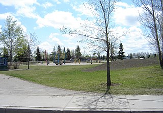
Meadowgreen is a neighbourhood located on the west side of the city in the Confederation Suburban Development Area in the city of Saskatoon, Saskatchewan, Canada. Meadowgreen is surrounded by an abundance of green space and walking trails without being a River side neighbourhood. The buffer zone along Circle Drive has a newly created walking trail. The southern buffer zone along 11th Street connects to the east with Fred Mendel Park of the Pleasant Hill neighbourhood and to the west with the off leash dog run located in the Confederation Suburban Centre neighbourhood. As well the newly re-located Meadowgreen Park and Peter Pond Park provide leisure activities such as basketball courts and playgrounds. Within the Confederation SDA of Saskatoon, the neighborhood of Meadowgreen comprises the area south of 22nd Street, north of the buffer zone between 11th Street and Appleby Drive, east of Circle Drive, and west of Avenue W South. Until the 1990s the portion of the community north of 18th Street was considered part of the Pleasant Hill community until the City of Saskatoon reorganized its community boundaries.

Nutana Suburban Development Area (SDA) is an area in Saskatoon, Saskatchewan (Canada). It is a part of the east side community of Saskatoon, and should not be confused with Nutana, one of the neighbourhoods within the Core Neighbourhoods SDA. It lies (generally) north of the outskirts of the City and the Rural Municipality of Corman Park No. 344, west of Lakewood SDA, south of the Core Neighbourhoods SDA SDA and University Heights SDA, and east of the South Saskatchewan River and Confederation SDA.

<span class="mw-page-title-main">Nutana Suburban Centre, Saskatoon</span> City of Saskatoon neighborhood in Saskatchewan, Canada

Nutana Suburban Centre is a mixed-development neighbourhood located in south-central Saskatoon, Saskatchewan, Canada. It is a classified as a "suburban centre" subdivision, composed of medium to high-density multiple-unit dwellings, commercial areas and civic facilities. As of 2009, the area is home to 2,962 residents. Housing in the neighbourhood consists of high-density apartment-style dwellings and row houses. The neighbourhood is considered a lower-income area, with an average family income of $34,474, an average dwelling value of $266,311 and a home ownership rate of 29.3%. The low average income but comparatively high dwelling value is due to the number of senior citizens residing in the neighbourhood. The age distribution of Nutana SC's population is skewed very highly toward residents age 65 and older.

<span class="mw-page-title-main">College Park, Saskatoon</span> Neighbourhood in Saskatoon, Saskatchewan, Canada

College Park is a primarily residential neighbourhood located in the east-central part of Saskatoon, Saskatchewan, Canada. The majority of its residents live in single-family detached dwellings, with a sizable minority of high-density, multiple-unit dwellings. As of 2011, the area is home to 5,470 residents. The neighbourhood is considered a middle-income area, with an average family income of $65,133, an average dwelling value of $232,228 and a home ownership rate of 58.9%.

<span class="mw-page-title-main">Grosvenor Park, Saskatoon</span> City of Saskatoon neighbourhood in Saskatchewan, Canada

Grosvenor Park is a mostly residential neighbourhood located in east-central Saskatoon, Saskatchewan, Canada. It is a suburban subdivision, composed of a near-even mix of low-density, single detached dwellings and apartment-style units. As of 2006, the area is home to 1,645 residents. The neighbourhood is considered an upper-income area, with an average family income of $67,544, an average dwelling value of $329,988 and a home ownership rate of 44.8%.

<span class="mw-page-title-main">Wildwood, Saskatoon</span> City of Saskatoon neighbourhood in Saskatchewan, Canada

Wildwood is a primarily residential neighbourhood located in the southeast part of Saskatoon, Saskatchewan, Canada. It includes part of the 8th Street business district. The majority of its residents live in a townhouse or apartment-style multiple unit dwellings, with a sizeable minority of low-density, single detached dwellings. As of 2016, the area is home to 7,645 residents. The neighbourhood has an average family income of $37,770, a homeownership rate of 67.0% and an average home sale price of $300,327.

<span class="mw-page-title-main">Briarwood, Saskatoon</span> Neighbourhood in Saskatoon, Saskatchewan, Canada

Briarwood is a residential neighbourhood located in the southeast part of Saskatoon, Saskatchewan, Canada. The majority of its residents live in low-density, single detached dwellings. As of 2009, the area is home to 4,473 residents. The neighbourhood is considered a very high-income area, with an average family income of $117,619, an average dwelling value of $449,158 and a home ownership rate of 97.0%.

<span class="mw-page-title-main">8th Street East (Saskatoon)</span> Road in Saskatoon, Saskatchewan

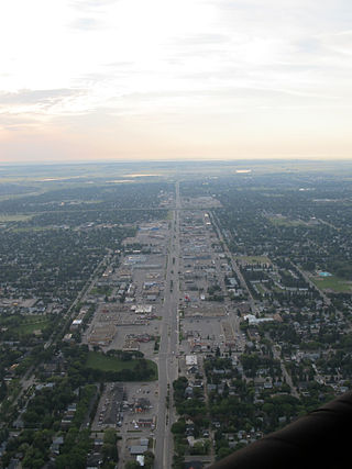
8th Street East is an arterial road serving the city of Saskatoon, Saskatchewan. It begins as a continuation of a minor residential street at Lorne Avenue in Saskatoon, and runs through the eastern part of city, eventually exiting the city limits as a country road.

<span class="mw-page-title-main">Lakeview, Saskatoon</span> City of Saskatoon neighbourhood in Saskatchewan, Canada

Lakeview is a primarily residential neighbourhood located in the southeast part of Saskatoon, Saskatchewan, Canada. The majority of its residents live in low-density, single detached dwellings, with a sizeable minority of semi-detached or apartment-style multiple unit dwellings. As of 2011, the area is home to 7,732 residents. The neighbourhood is considered a high income area, with an average family income of $120,042, an average dwelling value of $277,070 and a home ownership rate of 71.0%. It was the first community in Saskatoon to feature a man-made lake amenity.

<span class="mw-page-title-main">Adelaide/Churchill, Saskatoon</span> Neighbourhood in Saskatoon, Saskatchewan, Canada

Adelaide/Churchill is a mostly residential neighbourhood located in south-central Saskatoon, Saskatchewan, Canada. It is a suburban subdivision, consisting mostly of low-density, single detached dwellings. As of 2009, the area is home to 3,445 residents. The neighbourhood is considered a middle-income area, with an average family income of $78,438, an average dwelling value of $287,976 and a home ownership rate of 90.3%.

<span class="mw-page-title-main">Avalon, Saskatoon</span> Neighbourhood in Saskatoon, Saskatchewan, Canada

Avalon is a mostly residential neighbourhood located in south-central Saskatoon, Saskatchewan, Canada. It is a suburban subdivision, consisting mostly of low-density, single detached dwellings. As of 2007, the area is home to 3,214 residents. The neighbourhood is considered a middle-income area, with an average family income of $65,000, an average dwelling value of $168,444 and a home ownership rate of 77.3%.

<span class="mw-page-title-main">Forest Grove, Saskatoon</span> Neighbourhood in Saskatoon, Saskatchewan, Canada

Forest Grove is a primarily residential neighbourhood located in northeast Saskatoon, Saskatchewan, Canada. It is mostly made up of low-density single detached dwellings, with a sizeable minority of multiple-unit apartment dwellings. As of 2011, the area is home to 5,907 residents. The neighbourhood is considered a middle-income area, with an average family income of $70,487, an average dwelling value of $246,680 and a home ownership rate of 62.4%.

<span class="mw-page-title-main">Nutana Park, Saskatoon</span> Neighbourhood in Saskatoon, Saskatchewan, Canada

Nutana Park is a mostly residential neighbourhood located in south-central Saskatoon, Saskatchewan, Canada. It is a suburban subdivision, consisting mostly of low-density, single detached dwellings. As of 2021, the area is home to 2,959 residents. The neighbourhood is considered a middle-income area, with an average personal income of $42,630 and a home ownership rate of 83.3%. According to MLS data, the average sale price of a home as of 2020 was $346,929.

<span class="mw-page-title-main">The Willows, Saskatoon</span> City of Saskatoon neighbourhood in Saskatchewan, Canada

The Willows Residential Community and Golf Club, is a residential community in the Nutana Suburban Development Area in the city of Saskatoon, Saskatchewan. The Willows is south of Circle Drive which is concurrent with Saskatchewan Highway 16. Its northern boundary is the CN Rail line and the former Cartwright Street right-of-way ; to the east is Clarence Avenue and to the west is Lorne Avenue. The 36-hole Willows Golf & Country Club winds its way around the subdivision which when construction of homes began in 2004 became the city's first golf course community. Home construction began almost immediately after the land for the subdivision and the golf course was annexed from the rural municipality of Corman Park No. 344, Saskatchewan. The golf course, however, had been in operation for more than a decade before residential development began.

<span class="mw-page-title-main">Willowgrove, Saskatoon</span> Neighbourhood in Saskatoon, Saskatchewan, Canada

Willowgrove is a primarily residential neighbourhood located in the eastside of Saskatoon, Saskatchewan, Canada. It comprises a mix of mainly single-family detached houses and fewer multiple-unit dwellings. As of 2011, the area is home to 3,973 residents. The neighbourhood is considered a middle to high-income area, with an average family income of $96,002, an average dwelling value of $218,357 and a home ownership rate of 84.8%.

<span class="mw-page-title-main">Circle Drive</span> Road in Saskatoon, Saskatchewan

Circle Drive is a major road constructed as a ring road in Saskatoon, Saskatchewan, Canada. Its route constitutes both part of the Yellowhead Highway and Highway 11, signed as both along the entire length. It was first conceived in 1913 by the city commissioner and completed exactly 100 years later in 2013. Most of the route is a fully-controlled access freeway, however the segment between Airport Drive and Millar Avenue has at-grade intersections.

<span class="mw-page-title-main">C.N. Industrial, Saskatoon</span> Neighbourhood in Saskatoon, Saskatchewan, Canada

The CN Industrial Area is the industrial subdivision located in southern Saskatoon. It is also known as South Saskatoon, after the CN rail siding located in the area. It is a part of the Nutana Suburban Development Area. This industrial park was established with the Grand Trunk Pacific Railway crossing the South Saskatchewan River.

Kensington is a neighbourhood located in west Saskatoon, Saskatchewan, Canada that began construction in 2013. Around 2028, Kensington will reach completion and have an estimated population of 8,300. Kensington will feature Saskatoon's first application of the fused grid street network.

References

  1. "Stonebridge" (PDF). Neighbourhood Profiles. City of Saskatoon - City Planning Branch. 2010. Retrieved 2011-01-05.
  2. Willems, Lorraine (2003). "Historical Flashbacks - Rev. & Mrs. Walter Boldt". College of Prayer. Retrieved 2011-01-05.
  3. Populace Spring 2006. Vol. 8. City of Saskatoon - City Planning Branch. Spring 2006. p. 5.
  4. 1 2 Warren, Jeremy (2015-12-29). "A neighbourhood marks an anniversary: Stonebridge is 'basically finished'". The StarPhoenix . Retrieved 2015-12-29.
  5. "Future Growth & Development of Saskatoon" (PDF). City of Saskatoon - Community Services Department. December 2005. Archived from the original (PDF) on 2007-09-29. Retrieved 2007-10-28.
  6. Coolican, Lori (February 28, 2006). "Councillors clear way for Stonegate interchange". The StarPhoenix . CanWest MediaWorks Publications Inc. Retrieved 2011-01-07.
  7. "Overpass cost balloons $5.5M". The StarPhoenix . CanWest MediaWorks Publications Inc. January 5, 2007. Retrieved 2011-01-07.
  8. "Significant Dates". City of Saskatoon - City Archives. 2009. Archived from the original on 2011-09-30. Retrieved 2011-01-10.
  9. "Circle Drive and Preston Avenue Interchange Information Session on October 19". City of Saskatoon. Archived from the original on 2012-03-27. Retrieved 2010-11-04.
  10. "'Alm Crescent' street name gets bumpy ride". The StarPhoenix (reposted via Canada.com). CanWest MediaWorks Publications Inc. August 15, 2007. Retrieved 2013-01-04.
  11. "'Victor Road gets new name". The StarPhoenix (reposted via Canada.com). CanWest MediaWorks Publications Inc. April 26, 2016. Retrieved 2017-08-02.
  12. Current Members of Parliament , retrieved 2017-04-16
  13. Legislative Assembly of Saskatchewan - Members of the Legislative Assembly , retrieved 2017-04-16
  14. City Councillors - Saskatoon.ca, 2 February 2015, retrieved 2017-04-16
  15. 1 2 Active List of Saskatchewan Schools/Programs (PDF), retrieved 2018-02-10
  16. "Province announces plan to build 9 new schools using P3". CBC News. 2013-10-22. Retrieved 2013-10-22.
  17. "New Catholic schools get names". StarPhoenix . 2015-06-23. Archived from the original on 2015-07-05. Retrieved 2015-07-01.
  18. Giles, David (2016-10-12). "Saskatoon Board of Education decides on names for new elementary schools - Saskatoon". Global News. Retrieved 2017-07-13.
  19. "Joint-Use Schools Project - PreK-12 Education, Early Learning, and Schools". Government of Saskatchewan. Retrieved 2017-07-13.
  20. "Sod turned on long-term care facility". Global Television Network . CanWest. August 5, 2010. Retrieved 2002-11-20.
  21. "Stonebridge Community Association". City of Saskatoon - Community Development Branch. Retrieved 2011-01-05.
  22. "East Division". Saskatoon Police Service . Retrieved 2011-01-21.
  23. "Divisions - East". City of Saskatoon - Fire and Protective Services. Archived from the original on 2011-07-17. Retrieved 2011-01-21.
  24. "Routes & Schedules - Route 17" (PDF). City of Saskatoon - Transit Services. Retrieved 2011-01-21.