Grosvenor Park, Saskatoon

Last updated
Grosvenor Park
Grosvenor-Park-United-Church.jpg
Grosvenor Park United Church
Grosvenor-Park-map.png
Grosvenor Park location map
Coordinates: 52°7′5″N106°37′50″W / 52.11806°N 106.63056°W / 52.11806; -106.63056
CountryFlag of Canada (Pantone).svg  Canada
ProvinceFlag of Saskatchewan.svg  Saskatchewan
CitySaskatoon
Suburban Development Area Nutana
NeighbourhoodGrosvenor Park
Annexed1910-1919
Construction1946-1970
Government
  TypeMunicipal (Ward 6)
  Administrative body Saskatoon City Council
  Councillor Cynthia Block
Area
  Total0.65 km2 (0.25 sq mi)
Population
 (2006)
  Total1,697
   Average Income
$91,870
Time zone UTC-6 (UTC)
Website Varsity View Community Association

Grosvenor Park is a mostly residential neighbourhood located in east-central Saskatoon, Saskatchewan, Canada. It is a suburban subdivision, composed of a near-even mix of low-density, single detached dwellings and apartment-style units. As of 2006, the area is home to 1,645 residents. The neighbourhood is considered an upper-income area, with an average family income of $67,544, an average dwelling value of $329,988 and a home ownership rate of 44.8%. [1]

Contents

History

Saskatoon Islamic Centre (formerly Grosvenor Park School) Saskatoon-Islamic-Centre.jpg
Saskatoon Islamic Centre (formerly Grosvenor Park School)

The land for the Grosvenor Park neighbourhood was annexed by the city between 1910 and 1919. [2] According to a 1913 map of registered subdivisions, the neighbourhood was originally split in two sections called University View and Alexandra Park. [3] By the 1950s, the design of residential neighbourhoods departed from the previous grid system of roadways. A more modern system of curving residential streets, feeding into collector roads that connected to arterial roads was implemented, and the size of the development was based upon the drawing area of an elementary school. The philosophy was to create smaller, more aesthetically pleasing neighbourhoods with fewer intersections and more controlled traffic flow. Grosvenor Park was the first such neighbourhood designed with this idea in mind. [4] The majority of home construction occurred between 1946 and 1970 and was predominantly finished by 1980. [1]

The street names honour prominent early settlers of Nutana:

Grosvenor Park School opened in 1958 and was named after the subdivision as it was the first school in the area. [16] Due to declining enrolment, the school was closed and in 1993, the building was purchased by the Muslim Community of Saskatoon. Today it is the Saskatoon Islamic Centre. [17]

Government and politics

Grosvenor Park exists within the federal electoral district of Saskatoon—University. It is currently represented by Corey Tochor of the Conservative Party of Canada, who was first elected in 2019.

Provincially, Grosvenor Park lies within the constituency of Saskatoon University. It is currently represented by Eric Olauson of the Saskatchewan Party, first elected in 2016. [18]

In Saskatoon's non-partisan municipal politics, Grosvenor Park lies within ward 6. It is currently represented by Councillor Cynthia Block, first elected in 2016.

Institutions

Education

Saskatoon Misbah School
Address
Grosvenor Park, Saskatoon
222 Copland Crescent

, ,
S7K 3J8

Coordinates 52°07′06″N106°37′50″W / 52.118205°N 106.630629°W / 52.118205; -106.630629
Information
TypeElementary/Secondary
Religious affiliation(s) Islamic
Opened2000 (2000) [19]
School board Saskatoon Public Schools (Associate)
PrincipalMohamed Hajinoor
GradesPre-Kindergarten to Grade 9
Enrollment197 [20]  (2017)
Education systemPublic
LanguageEnglish
Website Saskatoon Misbah School

A former public elementary school, Grosvenor Park School, is now the Saskatoon Islamic Centre; they offer Quranic, Arabic and other Islamic studies on weekends during five months of the year. Public elementary school students who reside in the neighbourhood attend Brunskill School in neighboring Varsity View. In 2008, the Saskatoon Public School Division made the private Saskatoon Misbah School an associate school, which operates out of the Islamic Centre. [21]

Parks and recreation

Grosvenor Park Grosvenor-Park-2.jpg
Grosvenor Park

The Varsity View Community Association organizes events, delivers recreational and leisure programs, coordinates sports programs for children/youth and maintains the outdoor rink at Brunskill School. Its jurisdiction includes the neighbourhood of Grosvenor Park. [22]

Commercial

Commercial development is limited to the southern edge of the neighbourhood, where businesses lie within the 8th Street business district. Grosvenor Park Centre, a large strip mall complex with about 30 businesses, is located on the corner of 8th Street and Preston Avenue. [23] Opened in June 1960, it is Saskatoon's second-oldest shopping centre; the Churchill Shopping Centre in the Adelaide/Churchill neighbourhood is the oldest. [24] Another large strip mall complex is Cumberland Square, on the corner of 8th Street and Cumberland Avenue. In 2017 Cumberland Square underwent major redevelopment that included a new Save-On grocery store. In addition, there are 19 home-based businesses in the neighbourhood. [1]

Location

Grosvenor Park is located within the Nutana Suburban Development Area. It is bounded by 14th Street to the north, 8th Street to the south, Cumberland Avenue to the west, and Preston Avenue to the east. Roads are laid out in a mix of crescents and avenues. Main Street is a minor arterial street in the south part of the neighbourhood, separating the single detached housing area to the north from the apartment buildings to the south.

Related Research Articles

<span class="mw-page-title-main">Core Neighbourhoods SDA, Saskatoon</span> Place in Saskatchewan, Canada

The Core Neighbourhoods Suburban Development Area (SDA) is an area in Saskatoon, Saskatchewan, Canada. It is a part of the west and the east side community of Saskatoon, straddling the South Saskatchewan River. It lies (generally) south of the, east of Confederation SDA, to the west of Confederation SDA Lawson SDA University Heights SDA and north of Confederation SDA and Nutana SDA. This Suburban Development Area comprises early Saskatoon origins where the first towns of Nutana, West Saskatoon, and Riversdale came together to form the city of Saskatoon in 1906.

<span class="mw-page-title-main">Nutana, Saskatoon</span> City of Saskatoon neighborhood in Saskatchewan, Canada

Nutana is a primarily residential neighbourhood located near the centre of Saskatoon, Saskatchewan, Canada. It includes the business district of Broadway Avenue. It comprises a nearly even mixture of low-density, single detached dwellings and apartment-style multiple unit dwellings. As of 2009, the area is home to 6,261 residents. The neighbourhood is considered a middle to upper-income area, with an average family income of $67,657, an average dwelling value of $206,830 and a home ownership rate of 51.3%. First established in 1883, Nutana was the original settlement of what now makes up the city of Saskatoon.

Nutana Suburban Development Area (SDA) is an area in Saskatoon, Saskatchewan (Canada). It is a part of the east side community of Saskatoon, and should not be confused with Nutana, one of the neighbourhoods within the Core Neighbourhoods SDA. It lies (generally) north of the outskirts of the City and the Rural Municipality of Corman Park No. 344, west of Lakewood SDA, south of the Core Neighbourhoods SDA SDA and University Heights SDA, and east of the South Saskatchewan River and Confederation SDA.

<span class="mw-page-title-main">Nutana Suburban Centre, Saskatoon</span> City of Saskatoon neighborhood in Saskatchewan, Canada

Nutana Suburban Centre is a mixed-development neighbourhood located in south-central Saskatoon, Saskatchewan, Canada. It is a classified as a "suburban centre" subdivision, composed of medium to high-density multiple-unit dwellings, commercial areas and civic facilities. As of 2009, the area is home to 2,962 residents. Housing in the neighbourhood consists of high-density apartment-style dwellings and row houses. The neighbourhood is considered a lower-income area, with an average family income of $34,474, an average dwelling value of $266,311 and a home ownership rate of 29.3%. The low average income but comparatively high dwelling value is due to the number of senior citizens residing in the neighbourhood. The age distribution of Nutana SC's population is skewed very highly toward residents age 65 and older.

<span class="mw-page-title-main">Varsity View, Saskatoon</span> City of Saskatoon neighborhood in Saskatchewan, Canada

Varsity View is a mostly residential neighbourhood located near central Saskatoon, Saskatchewan, Canada. It is immediately south of the University of Saskatchewan campus. It is an older suburban subdivision, comprising a mixture of low-density, single detached dwellings, detached duplexes and apartment-style units. As of 2007, the area is home to 3,611 residents. The neighbourhood is considered a middle-income area, with an average family income of $50,587, an average dwelling value of $284,710 and a home ownership rate of 38.7%. Its proximity to the university gives this area its relatively high student population, almost 25% in 2005.

<span class="mw-page-title-main">Buena Vista, Saskatoon</span> City of Saskatoon neighbourhood in Saskatchewan, Canada

Buena Vista is a residential neighbourhood located near the centre of Saskatoon, Saskatchewan, Canada. It is an older suburban subdivision, including mostly low-density, single detached dwellings. As of 2011, the area is home to 3,271 residents. The neighbourhood is considered a middle-income area, with an average family income of $67,170, an average dwelling value of $251,560 and a home ownership rate of 77.7%.

<span class="mw-page-title-main">Central Business District, Saskatoon</span> Neighbourhood in Saskatoon, Saskatchewan, Canada

The Central Business District is one of seven development districts in Saskatoon, Saskatchewan, Canada. The central business district is Ward 6 of a Mayor-Council government represented by councillor Cynthia Block. Formerly called West Saskatoon, this area arose when the steam engines built their pumping stations on the lower west bank of the South Saskatchewan River. Retail enterprises sprang up around the newly created train station and rail yards. The city of Saskatoon's Central Business District has shopping malls and boutiques.

<span class="mw-page-title-main">Riversdale, Saskatoon</span> Saskatoon Neighborhood in Saskatchewan, Canada

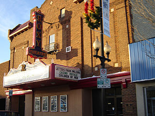
Riversdale is one of the oldest neighbourhoods in Saskatoon, Saskatchewan, Canada, located near the downtown area. It includes the business district of 20th Street. It consists mostly of low-density, single detached dwellings. As of 2021, the area was home to 2,534 residents.

<span class="mw-page-title-main">Mayfair, Saskatoon</span> Neighbourhood in Saskatoon, Saskatchewan, Canada

Mayfair is a neighbourhood in the city of Saskatoon, Saskatchewan, Canada. Mayfair started out as a community outside of the villages of Riversdale, Nutana and Saskatoon and appears as its own place name on a map of 1907. In 1909 there were 60 residences built in Mayfair, and in 1911, the City of Saskatoon had grown large enough to encompass Mayfair. Homeownership amongst the residents is at 68.2%.

<span class="mw-page-title-main">City Park, Saskatoon</span> Neighbourhood in Saskatoon, Saskatchewan, Canada

City Park is a mixed-use neighbourhood located near the center of Saskatoon, Saskatchewan, Canada. It comprises a mix of single-family detached homes, apartment buildings and other semi-detached dwellings. It also contains a number of commercial zones with businesses. As of 2009, the area was home to 4,405 residents. The neighbourhood is considered a middle-income area, with an average family income of $42,236, an average dwelling value of $245,254 and a home ownership rate of 28.6%.

<span class="mw-page-title-main">Haultain, Saskatoon</span> Neighbourhood in Saskatoon, Saskatchewan, Canada

Haultain is a mostly residential neighbourhood located in south-central Saskatoon, Saskatchewan, Canada. It is a suburban subdivision, consisting mostly of low-density, single detached dwellings. As of 2007, the area is home to 2,742 residents. The neighbourhood is considered a middle-income area, with an average family income of $47,890, an average dwelling value of $201,503 and a home ownership rate of 59.3%.

<span class="mw-page-title-main">Exhibition, Saskatoon</span> Neighbourhood in Saskatoon, Saskatchewan, Canada

The Exhibition subdivision of Saskatoon, Saskatchewan, Canada, is located on the banks of the South Saskatchewan River and was developed between the two major World Wars. To the west is the Diefenbaker Management Area which boasts the Diefenbaker park and Pioneer Cemetery. The park includes a medium-sized hill which is used for tobogganing and snowboarding, and the park itself is a frequently-used venue for picnics and public events and performances. The Exhibition community is also known as Thornton, after a (now-demolished) public elementary school that formerly served the area and early in its history also went by the name Bellevue.

<span class="mw-page-title-main">Adelaide/Churchill, Saskatoon</span> Neighbourhood in Saskatoon, Saskatchewan, Canada

Adelaide/Churchill is a mostly residential neighbourhood located in south-central Saskatoon, Saskatchewan, Canada. It is a suburban subdivision, consisting mostly of low-density, single detached dwellings. As of 2009, the area is home to 3,445 residents. The neighbourhood is considered a middle-income area, with an average family income of $78,438, an average dwelling value of $287,976 and a home ownership rate of 90.3%.

<span class="mw-page-title-main">History of Saskatoon</span>

The history of Saskatoon began with the first permanent non-indigenous settlement of Saskatoon, Saskatchewan, Canada, in 1883 when Toronto Methodists, wanting to escape the liquor trade in that city, decided to set up a "dry" community in the rapidly growing prairie region. As of 1882 this area was a part of the provisional district named Saskatchewan, North-West Territories (NWT). Their organization, the Temperance Colonization Society, first examined this area in 1882 and found that it would make an excellent location to found their community based on the ideals of the temperance movement; Saskatoon traditionally considers 1882 its founding year and thus marked its centennial in 1982. The settlers, led by John Neilson Lake, arrived on the site of what is now Saskatoon by traveling by railway from Ontario to Moose Jaw, Assiniboia, NWT, and then completing the final leg via horse-drawn cart. The plan for the Temperance Colony soon failed as the group was unable to obtain a large block of land within the community. Nonetheless, John Lake is commonly identified as the founder of Saskatoon; a public school, a park and two streets are named after him.

<span class="mw-page-title-main">Holliston, Saskatoon</span> City of Saskatoon neighbourhood in Saskatchewan, Canada

Holliston is a primarily residential neighbourhood located in the southeast part of Saskatoon, Saskatchewan, Canada. It includes part of the 8th Street business district. Just over half of its dwellings are single detached houses, with a sizeable minority of duplex or apartment-style multiple unit dwellings. As of 2007, the area is home to 3,412 residents. The neighbourhood is considered a middle-income area, with an average family income of $51,674, and a home ownership rate of 62.8%.

<span class="mw-page-title-main">Hudson Bay Park, Saskatoon</span> Neighbourhood in Saskatoon, Saskatchewan, Canada

Hudson Bay Park is geographically located in north west Saskatoon just south of Circle Drive along 33rd Street and Avenue P North. It is mainly characterized by single detached homes along with apartments that are less than five stories in height. Oliver Place and St. Joseph's Home are seniors residences located in this residential neighbourhood. This locale honours the pioneers of Saskatoon, as well as providing two very large park spaces which curve through the neighbourhood. The community was under construction mainly during the post war years between 1940 and 1960 when there was a housing shortage. The land for this neighbourhood was annexed during the City expansion around the time of 1910 to 1915. Following elementary school, students usually attend Mount Royal Collegiate in the neighboring area of Mount Royal or E.D. Feehan Catholic High School on Avenue M North a part of Westmount community. In 2006, the average family size was 2.1 residents. Statistics c2005 -

<span class="mw-page-title-main">Nutana Park, Saskatoon</span> Neighbourhood in Saskatoon, Saskatchewan, Canada

Nutana Park is a mostly residential neighbourhood located in south-central Saskatoon, Saskatchewan, Canada. It is a suburban subdivision, consisting mostly of low-density, single detached dwellings. As of 2007, the area is home to 2,748 residents. The neighbourhood is considered a middle-income area, with an average family income of $66,555, an average dwelling value of $257,789 and a home ownership rate of 85.1%. According to MLS data, the average sale price of a home as of 2013 was $356,116.

<span class="mw-page-title-main">Marr Residence</span> Historical property in Saskatoon, Saskatchewan

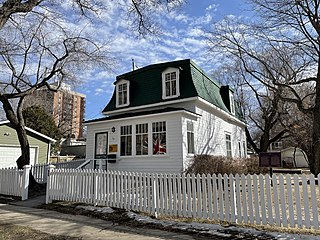
The Marr Residence is a National Historic Site located in the Nutana neighbourhood of Saskatoon, Saskatchewan, and was part of the original temperance colony that predated the city. Built in 1884 for stonemason Alexander "Sandy" Marr, it is the oldest building in Saskatoon on its original site. It was one of several houses requisitioned as a field hospital to treat wounded soldiers during the North-West Rebellion in 1885. When the hospital was closed in 1885 the home was returned to the Marr family. Although they left Saskatoon in 1889, the Marr family name remained associated with the house. The house remained a residential property until the 1970s.

References

  1. 1 2 3 "Grosvenor Park neighbourhood profile - 2007" (PDF). City of Saskatoon - City Planning Branch. 2007. Archived from the original (PDF) on 2012-03-12. Retrieved 2010-01-29.
  2. Community Services Department (Spring 2006). City Planning Branch (ed.). "Populace". 8 (1). City of Saskatoon: 5.{{cite journal}}: Cite journal requires |journal= (help)
  3. O'Brien, Jeff; Ruth W. Millar; William P. Delainey (2006). Roberta Coulter (ed.). Saskatoon: A History in Photographs. Coteau Books. p. 31. ISBN   1-55050-336-7.
  4. "A View From Above - Key to Landmarks". City of Saskatoon - Archives. Retrieved 2010-01-29.
  5. "History of Nutana". Archived from the original on 2011-07-21. Retrieved 2007-11-24.
  6. Bate, W.P. (June 8, 1927). "Saskatoon Gen Web Project - Narratives of Saskatoon 1882-1912". The Educational History of Saskatoon. University of Saskatchewan Bookstore. Retrieved 2007-11-24.
  7. "Copland, Thomas, Mary & Jessie" (PDF). City of Saskatoon - Parks Branch. Archived from the original (PDF) on 2012-02-27. Retrieved 2010-01-29.
  8. Brown, Archie (June 8, 1927). "Pioneer Settlers in and Around Saskatoon". Saskatoon Gen Web Project - Narratives of Saskatoon 1882-1912. University of Saskatchewan Bookstore. Retrieved 2007-11-24.
  9. DeCoursey, Elaine; Peggy Sarjeant (1994). "Site of the Garrison House - OnBroadway.ca". Saskatoon Heritage Society. Archived from the original on 2010-06-19. Retrieved 2007-11-25.
  10. "City of Saskatoon Archives - City Clerk's Office - City of Saskatoon Archives - Historical Resources". City of Saskatoon. Archived from the original on 2012-02-27. Retrieved 2010-01-29.
  11. "City History". City of Saskatoon - City Clerk's Office. Retrieved 2007-11-25.
  12. Lake, John (June 8, 1927). "The Temperance Colonization Society and the Foundation of Saskatoon". Saskatoon Gen Web Project - Narratives of Saskatoon 1882-1912. University of Saskatchewan Bookstore. Retrieved 2007-11-25.
  13. "Pioneer Settlers in and Around Saskatoon". Saskatoon Gen Web Project - Narratives of Saskatoon 1882-1912. University of Saskatchewan Bookstore. June 8, 1927. Retrieved 2007-11-25.
  14. Pederson, Jen (2009). Jeff O'Brien (ed.). "A Seat on Council" (PDF). City of Saskatoon Archives. Archived from the original (PDF) on 2012-03-12. Retrieved 2010-01-29.
  15. "History of Saskatoon". Saskatoon Gen Web Project - Narratives of Saskatoon 1882-1912. City of Saskatoon Archives. June 8, 1927. Retrieved 2007-11-25.
  16. Blashill, Lorraine (1982). Lorraine Blashill (ed.). From a Little Stone School... A Story of Saskatoon Public Schools. Modern Press Ltd. p. 141. Retrieved 2010-01-29.
  17. "Islamic Association of Saskatchewan (Saskatoon) - Community" . Retrieved 2007-11-23.
  18. Legislative Assembly of Saskatchewan - Members of the Legislative Assembly , retrieved 2017-04-16
  19. Historical Background , retrieved 2015-12-26
  20. Active List of Saskatchewan Schools/Programs (PDF), retrieved 2018-02-10
  21. Bernhardt, Darren (June 19, 2008). "Public trustees vote to give Islamic school associate status". The StarPhoenix . CanWest. Archived from the original on January 18, 2013. Retrieved 2012-11-02.
  22. "Varsity View Community Association". City of Saskatoon - Community Services. Retrieved 2010-01-29.
  23. "Grosvenor Park Centre" . Retrieved 2007-11-25.
  24. "Business Profile - Fall 2005" (PDF). Archived from the original (PDF) on 2007-12-02. Retrieved 2007-11-25.