Pleasant Hill is a neighbourhood of Saskatoon, Saskatchewan, Canada. The Governments are undertaking a major re-vitalization project of Pleasant Hill. $3.5 million is being invested in the business, and residential areas as well as in St. Mary's School. Together the Saskatoon Urban Renewal Project, the provincial government and the Western Economic Diversification project of the federal Government will result in neighbourhood overhauls. 29 lots zoned for business along 20th Street will be levelled and modern commercial upgrades put into place. Selected lots along Avenue N and Avenue O zoned as residential will be demolished to make way for affordable and decent homes. St. Mary's School will receive major renovations or replacement, possibly even a new community centre.[1]
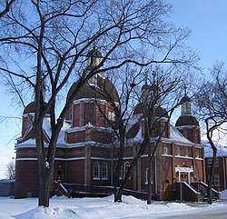
20th Street facing east towards downtown, St. Mary's Church location with steeple
Layout
Within the Core Neighbourhoods Suburban Development Area (West Side), the neighbourhood of Pleasant Hill is triangular in shape and is south of 23rd Street, North-west of the rail line which runs diagonally and east of Avenue W South. Streets are laid out east and west, avenues are laid out running north and south. The whole of the Pleasant Hill community is laid out in a grid pattern.
History
Dr. J.H.C. Willoughby Land Grant Patent showing he successfully proved up on his homestead.
The first name of the hill of this area was called Willoughby Hill.[2]
From 1884 to 1890, Dr. J. H. C. Wiloughby was Saskatoon's first post master and first physician on the east side of the River until after providing medical assistance to Middleton's troops during the Riel Rebellion (Revolution). From 1885 to 1900 he departed to Regina. John Henry C. returned with his wife (Miss Hilliard) and homesteaded at Willoughby Hill. His homestead was Section 30 Township 36 Range 5 West of the 3rd Meridian, and his home was located at the present location of St. Paul's Hospital. Being that he was a physician, his home was one of the first hospitals of the City of Saskatoon. In 1903 he helped to establish the first telephone in the area. He also became one of Saskatoon's first city councillors from 1907–1908.[3][4]
The boundaries of the Pleasant Hill community used to extend west of Avenue W to Circle Drive, but in the early 1990s the City of Saskatoon redrew many of its neighbourhood boundaries; as a result, the section west of Avenue W was renamed Meadowgreen.[5]
Demographics
Mother tongue 2006
In 2006 there were 4,415 people living in the Pleasant Hill community area. The majority of homes in the Pleasant Hill Community are Multi Unit Dwellings. This area was first settled at the turn of the 20th century, the houses were generally built before 1908. Pleasant Hill has been a Vibrant Communities Partner since 2001 and benefits from various community developments by Quint Development Corporation and Children's Hunger and Education Project.[6] In Pleasant Hill in 2006, the average household size was 2.2 and the homeownership was 25.5%. According to MLS data, the average sale price of a home as of 2013 was $186,367.[7]
In Saskatoon's non-partisan municipal politics, Pleasant Hill lies within ward 2. It is currently represented by Senos Timon. He was elected in 2024 and is the first Black person to sit on Saskatoon City Council.
Saskatoon Light and Power provides electrical utilities to all Saskatoon neighbourhoods which existed prior to 1958.[16] Water is treated and supplied by the City of Saskatoon Water and Wastewater Treatment Branch.[17] St. Paul's Hospital is located in Pleasant Hill, Royal University Hospital is located in the University of Saskatchewan Land Management area, and Saskatoon City Hospital is located in City Park. The Saskatoon Police Service Headquarters location is within the Central Business District located at 130 4th Avenue North.[18] The Central Division oversees the Central Business District, the Riversdale Business District, SIAST and nine other residential areas.[19] Pleasant Hill is served by the City of Saskatoon Saskatoon Fire & Protective Services, Fire Hall number 1 and head office is located at 125 Idylwyld Drive South, Riversdale.[20]
Parks and recreation
Grace Adam Metawewinihk Park
D.L. Hamilton Park – 1.63 acres (6,600m2)
Fred Mendel Park – 12.63 acres (51,100m2)
Pleasant Hill Rec. Unit – 2.94 acres (11,900m2)
St. George's Park – 0.93 acres (3,800m2)
Grace Adam Metawewinihk Park – 1.02 acres (4,100m2)
Pleasant Hill is serviced by the Saskatoon Transit bus routes #1, #2, #50 and #60. Route #5 also runs along Rusholme Road, a block north of the neighbourhood boundary.
Pleasant Hill Community Association provides leisure activities for various age groups and operates out of both Pleasant Hill School and St. Mary School.[22]
Saskatchewan Music Educators has introduced drum circles entitled Circles of Peace in various schools, of which the Pleasant Hill Community School is one.[23]
References
↑ Coolican, Lori. Saskatoon Star Phoenix (ed.). Gov'ts pitch in for Pleasant Hill renewal. Saskatoon Star Phoenix newspaper Saturday February 3, 2007. p.3.
↑ Celebrating a Century of Faith and Learning - A History of Saskatoon's Catholic Schools. Greater Saskatoon Catholic Schools. 2015. p.206. ISBN978-0-9947443-0-2.
This page is based on this Wikipedia article Text is available under the CC BY-SA 4.0 license; additional terms may apply. Images, videos and audio are available under their respective licenses.