Aspen Ridge, Saskatoon

Last updated
Aspen Ridge
Neighbourhood

Aspen Ridge Sign.jpg

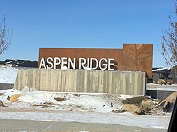
Aspen Ridge entrance sign
Coordinates: 52°10′46″N106°32′37″W / 52.17944°N 106.54361°W / 52.17944; -106.54361 Coordinates: 52°10′46″N106°32′37″W / 52.17944°N 106.54361°W / 52.17944; -106.54361
CountryFlag of Canada.svg  Canada
ProvinceFlag of Saskatchewan.svg  Saskatchewan
City Saskatoon
Suburban Development Area University Heights
Neighbourhood Aspen Ridge
Annexed 2010
Construction TBA
Government
  Type Municipal (Ward 10)
  Administrative body Saskatoon City Council
  Councillor Zach Jeffries
Area
  Total 2.57 km2 (0.99 sq mi)
Population
  Total 13,000 (est. upon buildout)
   Average Income $
Time zone UTC (UTC-6)

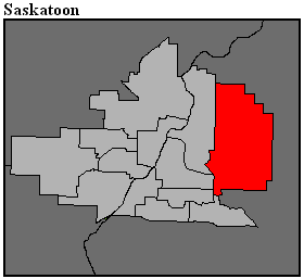
Aspen Ridge is a neighbourhood located in northeast Saskatoon, Saskatchewan, Canada, construction on which began in 2014. At full build-out, Aspen Ridge will eventually house an estimated 13,000 people. Unlike many of the city's suburban neighbourhoods, it will feature higher density housing on a grid network of roads. [1]

Saskatoon City in Saskatchewan, Canada

Saskatoon is the largest city in the Canadian province of Saskatchewan. It straddles a bend in the South Saskatchewan River in the central region of the province. It is located along the Trans-Canada Yellowhead Highway, and has served as the cultural and economic hub of central Saskatchewan since it was founded in 1882 as a Temperance colony.

Saskatchewan Province of Canada

Saskatchewan is a prairie and boreal province in western Canada, the only province without a natural border. It has an area of 651,900 square kilometres (251,700 sq mi), nearly 10 percent of which is fresh water, composed mostly of rivers, reservoirs, and the province's 100,000 lakes.

Canada Country in North America

Canada is a country in the northern part of North America. Its ten provinces and three territories extend from the Atlantic to the Pacific and northward into the Arctic Ocean, covering 9.98 million square kilometres, making it the world's second-largest country by total area. Canada's southern border with the United States is the world's longest bi-national land border. Its capital is Ottawa, and its three largest metropolitan areas are Toronto, Montreal, and Vancouver. As a whole, Canada is sparsely populated, the majority of its land area being dominated by forest and tundra. Consequently, its population is highly urbanized, with over 80 percent of its inhabitants concentrated in large and medium-sized cities, many near the southern border. Canada's climate varies widely across its vast area, ranging from arctic weather in the north, to hot summers in the southern regions, with four distinct seasons.

Contents

History

The land where Aspen Ridge is located was annexed on August 1, 2010. [2] The first concept drawings of Aspen Ridge (then unnamed) appeared in the University Heights Sector Plan in 2007. [3]

Government and politics

Aspen Ridge exists within the federal electoral district of Saskatoon—University. It is currently represented by Brad Trost of the Conservative Party of Canada. [4]

Saskatoon—University Federal electoral district

Saskatoon—University is a federal electoral district in Saskatchewan. It encompasses a portion of Saskatchewan previously included in the electoral districts of Saskatoon—Humboldt and Saskatoon—Wanuskewin.

Brad Trost Canadian politician

Bradley Ryan "Brad" Trost is a Conservative Member of Parliament in the House of Commons of Canada, representing the riding of Saskatoon—University. Before being elected, Trost worked as an exploration and mining geophysicist. Trost holds a B.Sc. in Geophysics and a B.A. in Economics, both from the University of Saskatchewan. He married in August 2012. Between August 2016 and May 2017, Trost campaigned to become Leader of the Conservative Party of Canada, placing fourth. Trost lost the renomination as the party candidate for his riding during the 43rd Federal election on March 10 to Corey Tochor, former speaker of the Saskatchewan Legislature.

Conservative Party of Canada political party in Canada founded in 2003

The Conservative Party of Canada, colloquially known as the Tories, is a federal political party in Canada. It was formed in 2003 from the multiple right-wing parties which had existed in Canada for over a century, historically grouped into two camps, "Red Tories" and "Blue Tories". The party sits at the centre-right to the right-wing of the Canadian political spectrum, with the Liberal Party of Canada positioned to the center-left. Like their federal Liberal rivals, the party is defined as a "big tent", welcoming a broad variety of members. The party's leader is Andrew Scheer, who serves as Leader of the Official Opposition.

Provincially, the area is within the constituency of Saskatoon Willowgrove. It is currently represented by Ken Cheveldayoff of the Saskatchewan Party, first elected in 2003. [5]

Saskatoon Willowgrove

Saskatoon Willowgrove is a provincial electoral district for the Legislative Assembly of Saskatchewan, Canada. It succeeded the former Saskatoon Silver Springs riding and was first contested in the 2016 election.

Ken Cheveldayoff is a Canadian provincial politician. He is the Saskatchewan Party member of the Legislative Assembly of Saskatchewan for the constituency of Saskatoon Willowgrove. In 2018 he was a candidate for the leadership of the Saskatchewan Party.

Saskatchewan Party

The Saskatchewan Party is a conservative, centre-right political party in the Canadian province of Saskatchewan. Since 2007, it has been the province's governing party, currently led by Premier Scott Moe. The party was established in 1997 by a coalition of former provincial Progressive Conservative and Liberal party members and supporters who sought to remove the Saskatchewan New Democratic Party (NDP) from power.

In Saskatoon's non-partisan municipal politics, Aspen Ridge lies within ward 10. It is currently represented by Councillor Zach Jeffries, first elected in 2012. [6]

Institutions

Education

No plans exist yet for schools in Aspen Ridge. St. Joseph High School and Centennial Collegiate are located in the University Heights Suburban Centre immediately to the south. The nearest elementary schools as of 2015 are located in nearby Silverspring and Willowgrove, though the city's public and separate school boards have yet to indicate where students residing in Aspen Ridge will be bused until such a time as schools are constructed in the community.

St. Joseph High School (Saskatoon) high school in Saskatoon, Canada

The St. Joseph High School is a high school in Saskatoon, Canada, a part of the University Heights Suburban Centre. St. Joseph High School is part of the Greater Saskatoon Catholic School division. Opened in 1995, it currently has approximately 1000 students.

Centennial Collegiate

Centennial Collegiate is a secondary school located on Nelson Road in Saskatoon, Saskatchewan, Canada. There are approximately 1,170 students enrolled at Centennial Collegiate as of 2017. Centennial also has a partnership with SaskTel Soccer Centre making it a shared-use facility.

University Heights Suburban Centre, Saskatoon Neighbourhood in Saskatoon, Saskatchewan, Canada

University Heights Suburban Centre is a mixed-development neighbourhood located in northeast Saskatoon, Saskatchewan, Canada. It is a classified as a "suburban centre" subdivision, composed of medium to high-density multiple-unit dwellings, commercial areas and civic facilities. As of 2009, the area is home to 1,479 residents. The neighbourhood is considered a middle-income area, with an average family income of $69,219, an average dwelling value of $237,698 and a home ownership rate of 85.7%. According to MLS data, the average sale price of a home as of 2013 was $304,903.

Parks and recreation

No plans exist yet for recreation facilities within the community, although the community plan shows the usual allotment of neighbourhood parks. A regional recreation facility, the SaskTel Soccer Centre, is located in the University Heights Suburban Centre to the south. The Forestry Farm Park and Saskatoon Zoo is also in the vicinity. A 24-metre wide Greenway has also been planned abutting the northwest border of Aspen Ridge, designed as a park, stormwater drainage channel, alternative transportation corridor and protective buffer to adjacent Northeast Swale natural area. [7]

Commercial

The neighbourhood concept plan identifies two commercial zones: a mixed-use commercial/residential area on the edge of the community in the southwest corner, and a purely commercial district in the southeast corner. Until such commercial development occurs, the nearest major retail area is several kilometres to the southwest in the University Heights Suburban Centre.

Location

Aspen Ridge is a roughly triangular shaped neighbourhood located within the University Heights Suburban Development Area. It is bounded to the south by the neighbourhood of Evergreen and the University of Saskatchewan Kearnan Farm, with the latter forming a green belt separation between Aspen Ridge and other communities to the south. To the north and east it is bounded by the proposed provincial perimeter highway, and to the north and west it is bounded by the Northeast Swale preserved lands [ citation needed ]. Its primary road access is via McOrmond Drive from the south and northwest which links to the North Commuter bridge, connecting to the northwest end of Saskatoon with Agra Road, a grid road, providing access to the perimeter highway to the east, though this road will be removed by further development[ citation needed ].

Related Research Articles

University Heights SDA, Saskatoon Place in Saskatchewan, Canada

University Heights Suburban Development Area (SDA) is an area in Saskatoon, Saskatchewan (Canada). It is a part of the east side community of Saskatoon. It lies (generally) south of the outskirts of the City and the Rural Municipality of Corman Park No. 344, east of the South Saskatchewan River, and Lawson SDA, north of the Lakewood SDA, and Nutana SDA.

Nutana Suburban Centre, Saskatoon City of Saskatoon neighborhood in Saskatchewan, Canada

Nutana Suburban Centre is a mixed-development neighbourhood located in south-central Saskatoon, Saskatchewan, Canada. It is a classified as a "suburban centre" subdivision, composed of medium to high-density multiple-unit dwellings, commercial areas and civic facilities. As of 2009, the area is home to 2,962 residents. Housing in the neighbourhood consists of high-density apartment-style dwellings and row houses. The neighbourhood is considered a lower-income area, with an average family income of $34,474, an average dwelling value of $266,311 and a home ownership rate of 29.3%. The low average income but comparatively high dwelling value is due to the number of senior citizens residing in the neighbourhood. The age distribution of Nutana SC's population is skewed very highly toward residents age 65 and older. According to MLS data, the average sale price of a home as of 2013 was $296,114.

Silverspring, Saskatoon Neighborhood in Saskatoon, Saskatchewan, Canada

Silverspring is a residential neighbourhood located in northeast Saskatoon, Saskatchewan, Canada. It is a suburban subdivision, composed mostly of low-density, single detached houses. As of 2007, the area is home to 4,936 residents. The neighbourhood is considered a high income area, with an average family income of $85,084, an average dwelling value of $322,670 and a home ownership rate of 97.8%. According to MLS data, the average sale price of a home as of 2013 was $407,171.

Arbor Creek, Saskatoon Neighbourhood in Saskatoon, Saskatchewan, Canada

Arbor Creek is a primarily residential neighbourhood located in northeast Saskatoon, Saskatchewan, Canada. It is mostly made up of low-density single detached dwellings. As of 2006, the area is home to 4,654 residents. The neighbourhood is considered a high-income area, with an average family income of $99,631, an average dwelling value of $327,262 and a home ownership rate of 92.5%. According to MLS data, the average sale price of a home as of 2013 was $416,596.

Lawson Heights, Saskatoon Neighbourhood in Saskatoon, Saskatchewan, Canada

Lawson Heights is a residential neighbourhood located in northern Saskatoon, Saskatchewan, which was developed beginning in the late 1970s.
College Park East, Saskatoon Neighbourhood in Saskatoon, Saskatchewan, Canada

College Park East is a primarily residential neighbourhood located in the east-central part of Saskatoon, Saskatchewan, Canada. The majority of its residents live in single-family detached dwellings, with a sizeable minority of high-density, multiple-unit dwellings. As of 2006, the area is home to 4,809 residents. The neighbourhood is considered a middle-income area, with an average family income of $67,946, an average dwelling value of $314,000 and a home ownership rate of 67.2%. According to MLS data, the average sale price of a home as of 2013 was $315,083.

Lawson Heights Suburban Centre, Saskatoon Neighbourhood in Saskatoon, Saskatchewan, Canada

Lawson Heights Suburban Centre is a neighbourhood that is maturing, and is located in north east Saskatoon. The neighbourhood features high density residential areas, major commercial suburban development area centre, transit mall, large green space parks which are slated for upgrade, and secondary institution. It is situated just east of the North West Industrial SDA and near the South Saskatchewan River Lawson Heights Suburban Centre combines a proximity to amenities offered by a comprehensive industrial development and the scenic river and river bank park system.

Lakewood Suburban Centre, Saskatoon Neighbourhood in Saskatoon, Saskatchewan, Canada

Lakewood Suburban Centre is a mixed-development neighbourhood located in southeast Saskatoon, Saskatchewan, Canada. It is a classified as a "suburban centre" subdivision, composed of mostly medium to high-density multiple-unit dwellings, commercial areas and civic facilities. As of 2011, the area is home to 1,850 residents. The neighbourhood is considered a middle-income area, with an average family income of $65,927, an average dwelling value of $227,522 and a home ownership rate of 76.8%. According to MLS data, the average sale price of a home as of 2013 was $252,618.

Briarwood, Saskatoon Neighbourhood in Saskatoon, Saskatchewan, Canada

Briarwood is a residential neighbourhood located in the southeast part of Saskatoon, Saskatchewan, Canada. The majority of its residents live in low-density, single detached dwellings. As of 2009, the area is home to 4,473 residents. The neighbourhood is considered a very high-income area, with an average family income of $117,619, an average dwelling value of $449,158 and a home ownership rate of 97.0%. According to MLS data, the average sale price of a home as of 2013 was $489,830.

Erindale, Saskatoon Neighbourhood in Saskatoon, Saskatchewan, Canada

Erindale is a primarily residential neighbourhood located in northeast Saskatoon, Saskatchewan, Canada. It is mostly made up of low-density single detached dwellings. As of 2011, the area is home to 4,338 residents. The neighbourhood is considered a high-income area, with an average family income of $123,336, an average dwelling value of $340,990 and a home ownership rate of 95.3%. According to MLS data, the average sale price of a home as of 2013 was $398,768.

Adelaide/Churchill, Saskatoon Neighbourhood in Saskatoon, Saskatchewan, Canada

Adelaide/Churchill is a mostly residential neighbourhood located in south-central Saskatoon, Saskatchewan, Canada. It is a suburban subdivision, consisting mostly of low-density, single detached dwellings. As of 2009, the area is home to 3,445 residents. The neighbourhood is considered a middle-income area, with an average family income of $78,438, an average dwelling value of $287,976 and a home ownership rate of 90.3%. According to MLS data, the average sale price of a home as of 2013 was $350,096.

Greystone Heights, Saskatoon City of Saskatoon neighbourhood in Saskatchewan, Canada

Greystone Heights is a mostly residential neighbourhood located in east-central Saskatoon, Saskatchewan, Canada. It is a suburban subdivision, consisting mostly of low-density, single detached dwellings and a sizeable minority of apartment-style multiple-unit dwellings. As of 2007, the area is home to 2,525 residents. The neighbourhood is considered a middle-income area, with an average family income of $58,811, an average dwelling value of $241,850 and a home ownership rate of 58.1%. According to MLS data, the average sale price of a home as of 2013 was $338,763.
Forest Grove, Saskatoon Neighbourhood in Saskatoon, Saskatchewan, Canada

Forest Grove is a primarily residential neighbourhood located in northeast Saskatoon, Saskatchewan, Canada. It is mostly made up of low-density single detached dwellings, with a sizeable minority of multiple-unit apartment dwellings. As of 2011, the area is home to 5,907 residents. The neighbourhood is considered a middle-income area, with an average family income of $70,487, an average dwelling value of $246,680 and a home ownership rate of 62.4%. According to MLS data, the average sale price of a home as of 2013 was $304,527.

Willowgrove, Saskatoon Neighbourhood in Saskatoon, Saskatchewan, Canada

Willowgrove is a primarily residential neighbourhood located in northeast Saskatoon, Saskatchewan, Canada. It comprises a mix of mainly single-family detached houses and fewer multiple-unit dwellings. As of 2011, the area is home to 3,973 residents. The neighbourhood is considered a middle to high-income area, with an average family income of $96,002, an average dwelling value of $218,357 and a home ownership rate of 84.8%.

Westview is a suburban community in the Confederation Suburban Development Area (SDA) of Saskatoon, Saskatchewan. Originally named "Tuxedo Park" by real estate developers in 1912, the area remained undeveloped until the 1960s. The east half of Westview is located on land annexed by the city in 1911, while the western half did not become part of Saskatoon until 1960.

Kensington is a neighbourhood located in west Saskatoon, Saskatchewan, Canada that began construction in 2013. Around 2028, Kensington will reach completion and have an estimated population of 8,300. Kensington will feature Saskatoon's first application of the fused grid street network.

Evergreen, Saskatoon Neighbourhood in Saskatoon, Saskatchewan, Canada

Evergreen is a residential neighbourhood under construction within the University Heights Suburban Development Area of Saskatoon, Saskatchewan. The residential area is constructed around the village centre and a larger district village. The subdivision was created in 2010. Evergreen is projected to have a density of 8.6 units per acre, becoming one of the densest neighbourhoods in Saskatoon when complete.

References

  1. Hamilton, Charles (2013-03-09). "New suburb to feature high-density design". The StarPhoenix . Postmedia Network . Retrieved 2013-10-07.
  2. "Boundary Alteration". City of Saskatoon - Planning and Development Branch. Archived from the original on 2014-12-08. Retrieved 2013-03-21.
  3. "University Heights Sector". City of Saskatoon - Planning and Development Branch. Archived from the original on 2013-03-01. Retrieved 2013-03-21.
  4. Current Members of Parliament , retrieved 2017-04-16
  5. Legislative Assembly of Saskatchewan - Members of the Legislative Assembly , retrieved 2017-04-16
  6. City Councillors - Saskatoon.ca , retrieved 2017-04-16
  7. Tank, Phil (2016-02-07). "New suburb to feature high-density design". The StarPhoenix . Postmedia Network . Retrieved 2018-02-26.