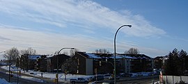
Meadowgreen is a neighbourhood located on the west side of the city in the Confederation Suburban Development Area in the city of Saskatoon, Saskatchewan, Canada. Meadowgreen is surrounded by an abundance of green space and walking trails without being a River side neighbourhood. The buffer zone along Circle Drive has a newly created walking trail. The southern buffer zone along 11th Street connects to the east with Fred Mendel Park of the Pleasant Hill neighbourhood and to the west with the off leash dog run located in the Confederation Suburban Centre neighbourhood. As well the newly re-located Meadowgreen Park and Peter Pond Park provide leisure activities such as basketball courts and playgrounds. Within the Confederation SDA of Saskatoon, the neighborhood of Meadowgreen comprises the area south of 22nd Street, north of the buffer zone between 11th Street and Appleby Drive, east of Circle Drive, and west of Avenue W South. Until the 1990s the portion of the community north of 18th Street was considered part of the Pleasant Hill community until the City of Saskatoon reorganized its community boundaries.

Confederation Suburban Development Area (SDA) is an area in Saskatoon, Saskatchewan (Canada). It is a part of the west side community of Saskatoon. It lies (generally) north of the outskirts of the City and the Rural Municipality of Corman Park No. 344, west of downtown Saskatoon, and the Core Neighbourhoods SDA, south of the North West Industrial SDA, and east of the new Blairmore SDA.

Lakewood Suburban Development Area (SDA) is an area in Saskatoon, Saskatchewan, Canada. It is a part of the east side community of Saskatoon. It lies (generally) north of the outskirts of the City and the Rural Municipality of Corman Park No. 344, west of outskirts of the City and the Rural Municipality of Corman Park No. 344, south of the University Heights SDA, and east of the Nutana SDA.

University Heights Suburban Development Area (SDA) is an area in Saskatoon, Saskatchewan (Canada). It is a part of the east side community of Saskatoon. It lies (generally) south of the outskirts of the City and the Rural Municipality of Corman Park No. 344, east of the South Saskatchewan River, and Lawson SDA, north of the Lakewood SDA, and Nutana SDA.

Nutana Suburban Centre is a mixed-development neighbourhood located in south-central Saskatoon, Saskatchewan, Canada. It is a classified as a "suburban centre" subdivision, composed of medium to high-density multiple-unit dwellings, commercial areas and civic facilities. As of 2009, the area is home to 2,962 residents. Housing in the neighbourhood consists of high-density apartment-style dwellings and row houses. The neighbourhood is considered a lower-income area, with an average family income of $34,474, an average dwelling value of $266,311 and a home ownership rate of 29.3%. The low average income but comparatively high dwelling value is due to the number of senior citizens residing in the neighbourhood. The age distribution of Nutana SC's population is skewed very highly toward residents age 65 and older.

Pleasant Hill is a neighbourhood of Saskatoon, Saskatchewan, Canada. The Governments are undertaking a major re-vitalization project of Pleasant Hill. $3.5 million is being invested in the business, and residential areas as well as in St. Mary's School. Together the Saskatoon Urban Renewal Project, the provincial government and the Western Economic Diversification project of the federal Government will result in neighbourhood overhauls. 29 lots zoned for business along 20th Street will be levelled and modern commercial upgrades put into place. Selected lots along Avenue N and Avenue O zoned as residential will be demolished to make way for affordable and decent homes. St. Mary's School will receive major renovations or replacement, possibly even a new community centre.

Riversdale is one of the oldest neighbourhoods in Saskatoon, Saskatchewan, Canada, located near the downtown area. It includes the business district of 20th Street. It consists mostly of low-density, single detached dwellings. As of 2021, the area was home to 2,534 residents.
Massey Place, is a geographically localised subdivision of the Confederation Suburban Development Area in the city of Saskatoon, Saskatchewan which is nestled around Archibald McDonald Park. Mcdonald Park is centrally located along the northern perimeter of 33rd Street East. The school yards of both Vincent Massey School and Bishop Klein School have their western boundaries along Archibald McDonald Park which has as its resources ball diamonds, soccer pitches, winter ice rinks, and playground facilities. Massey Place neighbourhood is close to amenities provided by both the commercial district of the Confederation Suburban Centre.
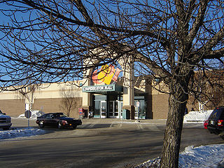
Confederation Mall is a 329,128 sq. ft. shopping mall located at 22nd Street and Circle Drive in Saskatoon, Saskatchewan, Canada. The mall was originally named Confederation Park Plaza when it opened in mid-1973, at which time its anchor tenants were Canada Safeway and Woolco.
Fairhaven is a neighbourhood in Saskatoon, Saskatchewan, Canada, located towards the west end of the city, south of 22nd Street and west of Circle Drive.

The Blairmore Suburban Centre is a community service/commercial/residential community currently under development in western Saskatoon, Saskatchewan. It is part of the city's Blairmore Suburban Development Area, a large region annexed from the Rural Municipality of Corman Park No. 344 in 2005. Ultimately, the SDA will consist of seven new neighbourhoods, plus the Blairmore Suburban Centre, which is the first component of the SDA to be developed.

Montgomery Place is a post-World War II community erected for veterans outside Saskatoon, Saskatchewan, Canada, that consists primarily of residential homes. It was amalgamated within the city of Saskatoon in 1956, and is now a National Historic Site. Montgomery Place has an average household size of 3.2 persons, and homeownership is at 93.7%. According to MLS data, the average sale price of a home as of 2013 was $403,840. It was named in honour of Field Marshal The 1st Viscount Montgomery of Alamein, the famous Ulster Scots commander in the British Army during the Second World War.

Dundonald is a neighbourhood located in the northwest corner of Saskatoon, Saskatchewan. The neighbourhood was built in the 1980s, and served as the last development of the northwest corner of the city, prior to the development of Hampton Village. Dundonald is surrounded by a large landscaped park, with a storm pond. In comparison, the neighbourhood of Dundonald with a 2001 census population of 5,285 is larger than the Saskatchewan city of Melville which had a population of 4,149 in 2006, and 4,453 in 2001 and Dundonald is also larger than the provincial city of Humboldt which was 4,998 in 2006, and 5,161 in 2001. In Saskatchewan rural towns must maintain a population above 5,000 to apply for city status.

Hudson Bay Park is geographically located in north west Saskatoon just south of Circle Drive along 33rd Street and Avenue P North. It is mainly characterized by single detached homes along with apartments that are less than five stories in height. Oliver Place and St. Joseph's Home are seniors residences located in this residential neighbourhood. This locale honours the pioneers of Saskatoon, as well as providing two very large park spaces which curve through the neighbourhood. The community was under construction mainly during the post war years between 1940 and 1960 when there was a housing shortage. The land for this neighbourhood was annexed during the City expansion around the time of 1910 to 1915. Following elementary school, students usually attend Mount Royal Collegiate in the neighboring area of Mount Royal or E.D. Feehan Catholic High School on Avenue M North a part of Westmount community. In 2006, the average family size was 2.1 residents. Statistics c2005 -

Parkridge is a residential community in western Saskatoon, Saskatchewan, located on land annexed by the city between 1975 and 1979. Development of the subdivision initially began in the early 1980s. The extreme west end of the neighbourhood remained undeveloped until the subsequent creation of the adjacent Blairmore Suburban Centre led to the final phase of Parkridge being built out in the early 2010s. Whereas the majority of residents are employed in the sales and service sector, the next highest employer is business, finance and administration. The two main age groups are those in their 40s and teenagers as of 2005. Until recently Parkridge was the farthest western neighbourhood of Saskatoon south of 22nd Street. However, new construction will soon see Neighbourhood 2 of the Blairmore SDA bear that distinction. In comparison, the neighbourhood of Parkridge with a 2001 census population of 4,505 is larger than the Saskatchewan city of Melville which had a population of 4,149 in 2006, and 4,453 in 2001 and Parkridge is a little smaller than the provincial city of Humboldt which was 4,998 in 2006, and 5,161 in 2001. In Saskatchewan rural towns must maintain a population above 5,000 to apply for city status. According to MLS data, the average sale price of a home as of 2013 was $327,072.
Westview is a suburban community in the Confederation Suburban Development Area (SDA) of Saskatoon, Saskatchewan. Originally named "Tuxedo Park" by real estate developers in 1912, the area remained undeveloped until the 1960s. The east half of Westview is located on land annexed by the city in 1911, while the western half did not become part of Saskatoon until 1960.

South West Industrial, also known as Holiday Park Industrial and labelled SEDCO Industrial on city maps of the 1980s and 1990s, is an industrial subdivision located in the Confederation SDA in southwest Saskatoon, Saskatchewan, Canada.
22nd Street is an arterial road in Saskatoon, Saskatchewan. It begins as 22nd Street East in the Central Business District. Going west it passes the Midtown Plaza and TCU Place. At the intersection with Idylwyld Drive, it becomes 22nd Street West. Through the inner city neighbourhoods of Caswell Hill, Riversdale, Westmount, and Pleasant Hill, it contains a mixture of commercial and residential development. It then connects with Circle Drive via an interchange. Next to the interchange is the Confederation Mall. Across from that is a Real Canadian Superstore. From there is passes by the neighbourhoods of Pacific Heights, Blairmore, and Kensington. The road then heads out of the city and continues on as Highway 14.