Related Research Articles

Greater Los Angeles is the most populous metropolitan area in the U.S. state of California, encompassing five counties in Southern California extending from Ventura County in the west to San Bernardino County and Riverside County in the east, with Los Angeles County in the center, and Orange County to the southeast. The Los Angeles–Anaheim–Riverside combined statistical area (CSA) covers 33,954 square miles (87,940 km2), making it the largest metropolitan region in the United States by land area. The contiguous urban area is 2,281 square miles (5,910 km2), whereas the remainder mostly consists of mountain and desert areas. With a population of 20.6 million in 2024, it is the second-largest metropolitan area in the country, behind New York, as well as one of the largest megacities in the world.

The Los Angeles River, historically known as Paayme Paxaayt'West River' by the Tongva and the Río Porciúncula'Porciúncula River' by the Spanish, is a major river in Los Angeles County, California. Its headwaters are in the Simi Hills and Santa Susana Mountains, and it flows nearly 51 miles (82 km) from Canoga Park through the San Fernando Valley, Downtown Los Angeles, and the Gateway Cities to its mouth in Long Beach, where it flows into San Pedro Bay. While the river was once free-flowing and frequently flooding, forming alluvial flood plains along its banks, it is currently notable for flowing through a concrete channel on a fixed course, which was built after a series of devastating floods in the early 20th century.

The Pacific Electric Railway Company, nicknamed the Red Cars, was a privately owned mass transit system in Southern California consisting of electrically powered streetcars, interurban cars, and buses and was the largest electric railway system in the world in the 1920s. Organized around the city centers of Los Angeles and San Bernardino, it connected cities in Los Angeles County, Orange County, San Bernardino County and Riverside County.

The San Fernando Valley, known locally as the Valley, is an urbanized valley in Los Angeles County, California. Situated northwards of the Los Angeles Basin, it comprises a large portion of Los Angeles, the incorporated cities of Burbank, Calabasas, Glendale, Hidden Hills and San Fernando, plus several unincorporated areas. The valley is the home of Warner Bros. Studios, Walt Disney Studios, and the Universal Studios Hollywood theme park.

Los Angeles has a complex multimodal transportation infrastructure, which serves as a regional, national and international hub for passenger and freight traffic. The system includes the United States' largest port complex; an extensive freight and passenger rail infrastructure, including light rail lines and rapid transit lines; numerous airports and bus lines; vehicle for hire companies; and an extensive freeway and road system. People in Los Angeles rely on cars as the dominant mode of transportation, but since 1990 the Los Angeles County Metropolitan Transportation Authority has built over one hundred miles (160 km) of light and heavy rail serving more and more parts of Los Angeles and the greater area of Los Angeles County; Los Angeles was the last major city in the United States to get a permanent rail system installed.

Little Armenia is a neighborhood in Central Los Angeles, California. It is named after the Armenians who escaped genocide and made their way to Los Angeles during the early part of the 20th century.

East Hollywood is a densely populated neighborhood of 78,000+ residents that is part of the Hollywood area of the central region of Los Angeles, California. It is notable for being the site of Los Angeles City College, Barnsdall Park, and a hospital district. There are seven public and five private schools, a Los Angeles Public Library branch, and three hospitals. Almost two-thirds of the people living there were born outside the United States, and 90% were renters. In 2000, the neighborhood had high percentages of never-married people and single parents.

The C Line is a 19.3-mile (31.1 km) light rail line running between Redondo Beach and Norwalk within Los Angeles County, California. It is one of six lines forming the Los Angeles Metro Rail system and opened on August 12, 1995. Along the route, the line serves the cities of Downey, El Segundo, Hawthorne, Norwalk and Lynwood, the Los Angeles community of Westchester, and several unincorporated communities in the South Los Angeles region including Athens, Del Aire, and Willowbrook. A free shuttle bus to Los Angeles International Airport (LAX) is available at the line's Aviation/LAX station.

Chavez Ravine is a shallow canyon in Los Angeles, California. It sits in a large promontory of hills north of downtown Los Angeles, next to Major League Baseball's Dodger Stadium. Chavez Ravine was named for a 19th-century Los Angeles councilman who had originally purchased the land in the Elysian Park area.

California's 29th congressional district is a congressional district in the U.S. state of California based in the north central San Fernando Valley. The district is represented by Democrat Tony Cárdenas.
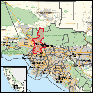
California's 30th congressional district is a congressional district in the U.S. state of California. The 30th district takes in all of Burbank and Glendale, the Linda Vista neighborhood of Pasadena, and the Los Angeles communities of Tujunga, Hollywood, West Hollywood, Edendale, Park La Brea, Hancock Park, and westside Echo Park. The district is currently represented by Democrat Adam Schiff.

Self-Help Graphics & Art, Inc. is a community arts center in East Los Angeles, California, United States. The building is a mix Beaux-Arts and vernacular architecture built in 1927, and was designed by Postle & Postle. Formed during the cultural renaissance that accompanied the Chicano Movement, or Self Help, as it is sometimes called, was one of the primary centers that incubated the nascent Chicano art movement, and remains important in the Chicano art movement, as well as in the greater Los Angeles community, today. SHG also hosts musical and other performances, and organizes Los Angeles's annual Day of the Dead festivities. Throughout its history, the organization has worked with well-known artists in the Los Angeles area such as Los Four and the East Los Streetscapers, but it has focused primarily on training and giving exposure to young and new artists, many of whom have gone on to national and international prominence.
TreePeople is an educational and training environmental advocacy organization based in Los Angeles, California. The TreePeople organization advocates and works to support sustainable urban ecosystems in the Greater Los Angeles area through education, volunteer community-based action, and advocacy.

Northeast Los Angeles is a 17.18 sq mi (44.5 km2) region of Los Angeles County, comprising seven neighborhoods within Los Angeles. The area is home to Occidental College located in Eagle Rock.
Measure R was a ballot measure during the November 2008 elections in Los Angeles County, California, that proposed a half-cent sales taxes increase on each dollar of taxable sales for thirty years in order to pay for transportation projects and improvements. The measure was approved by voters with 67.22% of the vote, just over the two-thirds majority required by the state of California to raise local taxes. The project was touted as a way to "improve the environment by getting more Angelenos out of their cars and into the region's growing subway, light rail, and bus services." It will result in the construction or expansion of a dozen rail lines in the county.

Freeway removal is a public policy of urban planning to demolish freeways and create mixed-use urban areas, parks, residential, commercial, or other land uses. Such highway removal is often part of a policy to promote smart growth, transit-oriented development, and pedestrian- and bicycle-friendly cities. In some cases freeways are re-imagined as boulevards, rebuilt as below-grade freeways underneath caps-and-stitches, or relocated through less densely-developed areas.

Vermont Vista is a neighborhood in Los Angeles, California, within the South Los Angeles area.

The Citadel Outlets are an outlet mall in the City of Commerce, California, along the Santa Ana Freeway southeast of Downtown Los Angeles, which features the Exotic Revival architecture of a tire factory, whose partial remnants the complex occupies, built in the style of the castle of Assyrian king Sargon II.

The Inglewood Transit Connector Project is a proposed 1.6-mile (2.6 km) fully elevated, automated people mover system in Inglewood, California, that will connect the Downtown Inglewood station on the K Line of the Los Angeles Metro Rail system to the major sports and entertainment venues in the city: Kia Forum, SoFi Stadium, Hollywood Park Casino, and the Intuit Dome. The project was planned to break ground in 2024 and begin operations in late 2027, ahead of the 2028 Summer Olympics that will use some of the venues. However, the Federal Transit Administration (FTA) recently reported that the transit connector will not open for revenue service until early 2030.
References
- ↑ Sharp, Steven (2012-08-22). "Hollywood Central Park Seeks $1.5 Million to Complete EIR". Urbanize LA. Retrieved 2017-12-09.
- ↑ "About Friends of The". Hollywood Central Park. Retrieved 2017-12-09.
- ↑ https://www.transportation.gov/briefing-room/biden-harris-administration-announces-first-ever-awards-program-reconnect-communities
- ↑ https://la.urbanize.city/post/la-scores-160m-feds-transportation-and-infrastructure-ahead-2028-olympics
- ↑ "hollywood central park - Google Search". Google.com. Retrieved 23 December 2017.