
Larne is a town on the east coast of County Antrim, Northern Ireland, with a population of 18,853 at the 2021 census. It is a major passenger and freight roll-on roll-off port. Larne is administered by Mid and East Antrim Borough Council. Together with parts of the neighbouring districts of Antrim and Newtownabbey and Causeway Coast and Glens, it forms the East Antrim constituency for elections to the Westminster Parliament and Northern Ireland Assembly. The civil parish is in the historic barony of Glenarm Upper.

Newtownabbey is a large settlement north of Belfast city centre in County Antrim, Northern Ireland. It is separated from the rest of the city by Cavehill and Fortwilliam golf course, but it still forms part of the Belfast metropolitan area. It surrounds Carnmoney Hill, and was formed from the merging of several small villages including Whiteabbey, Glengormley and Carnmoney. At the 2011 census, Metropolitan Newtownabbey Settlement had a population of 65,646, making it the third largest settlement in Northern Ireland. It is part of Antrim and Newtownabbey Borough Council.
Larne Borough Council was a Local Council in County Antrim in Northern Ireland. It merged with Ballymena Borough Council and Carrickfergus Borough Council in May 2015 under the reorganisation of local government in Northern Ireland to become Mid and East Antrim Borough Council.

Greenisland is a town in County Antrim, Northern Ireland. It lies 7 miles north-east of Belfast and 3 miles south-west of Carrickfergus. The town is on the coast of Belfast Lough and is named after a tiny islet to the west, the Green Island.

Whitehead is a large seaside village on the east coast of County Antrim, Northern Ireland, lying almost midway between the towns of Carrickfergus and Larne. It lies within the civil parish of Templecorran, the historic barony of Belfast Lower, and is part of Mid and East Antrim Borough Council. Before the Plantation of Ulster its name was recorded as both Whitehead and Kinbaine.

Olderfleet Castle is a four-storey towerhouse, the remains of which stand on Curran Point to the south of Larne Harbour in Larne, County Antrim, Northern Ireland. The place name of Olderfleet may be a corruption of Ulfrecksfiord, the Viking name for Larne Lough.

Ballygally or Ballygalley is a village and holiday resort in County Antrim, Northern Ireland which lies on the Antrim coast, approximately 3 miles north of Larne. It is also a townland of 769 acres and is situated in the civil parish of Carncastle and the historic barony of Glenarm Upper. It had a population of 821 in the 2011 Census. It is located within the Mid and East Antrim Borough Council area.
Carincastle or Cairncastle is a small village and civil parish in County Antrim, Northern Ireland near the town of Larne and inland from the village of Ballygally. It had a population of 66 people in the 2001 Census. It is part of the Mid and East Antrim Borough Council area.

Glynn is a small village and civil parish in the Mid and East Antrim Borough Council area of County Antrim, Northern Ireland. It lies a short distance south of Larne, on the shore of Larne Lough. As of the 2011 census, the Glynn ward had a population of 2,027 people.

Ballycraigy is a townland and housing estate in Antrim town, Northern Ireland. According to the census for Ballycraigy ward the estate has approximately 865 residents.
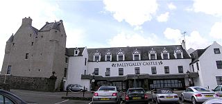
Ballygally Castle is in the village of Ballygally, County Antrim, Northern Ireland, located approximately 3 miles north of Larne. The castle overlooks the sea at the head of Ballygally Bay. Now run as a hotel, it is the only 17th century building still used as a residence in Northern Ireland, and is reputed to be one of the most haunted places in all of Ulster.

Carnlough is a village in County Antrim, Northern Ireland. It is situated in Mid and East Antrim district, as well the historic barony of Glenarm Lower, and the civil parishes of Ardclinis and Tickmacrevan. It had a population of 1,512 people at the 2011 Census.

Glenoe or Gleno is a hamlet in County Antrim, Northern Ireland. It is halfway between Larne and Carrickfergus. In the 2001 Census, it had a population of 87 people. Glenoe is in the Mid and East Antrim Borough Council area.
Mullaghboy is a small village and townland on Islandmagee in County Antrim, Northern Ireland. It is situated in the civil parish of Islandmagee and the historic barony of Belfast Lower. It is within the Larne Borough Council area. It had a population of 364 people in the 2011 Census..
Sir Thomas James Dixon, 2nd Baronet, PC (NI), was a Northern Ireland politician.
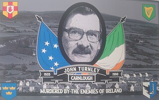
John Turnley was an Irish politician and activist. Originally from a unionist background, he was gradually drawn to Irish nationalism and became a republican activist. He was assassinated in 1980 by loyalists in Carnlough, County Antrim.

Antrim and Newtownabbey is a local government district in Northern Ireland. The district was created on 1 April 2015 by merging the Borough of Antrim with the Borough of Newtownabbey. The local authority is Antrim and Newtownabbey Borough Council.

Drains Bay is a small residential and commuter settlement about 3 kilometres (1.9 mi) north of Larne and south of Ballygalley on the coast of County Antrim, Northern Ireland.

Kilwaughter is a small village in County Antrim, Northern Ireland, near the town of Larne. It is in an electoral ward situated within the Mid and East Antrim Borough Council area. Kilwaughter is a rural village or Hamlet.
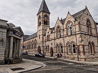
Larne Town Hall is a municipal structure in Upper Cross Street in Larne, County Antrim, Northern Ireland. The structure, which was the meeting place of Larne Borough Council, is a Grade B+ listed building.
 Garden
 Ice house
 Walkway
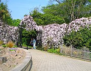 Gate
Gate Sundial
 View towards Larne


