Annalong Forest

Last updated

Annalong Forest
Annalong Wood and the Mourne Mountains - geograph.org.uk - 1138157.jpg
Annalong Wood with the Mourne Mountains in the background
Map
Relief Map of Northern Ireland.png
Red pog.svg
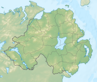
Location of Annalong Forest
Geography
LocationDown,Northern Ireland,United Kingdom
Coordinates 54°08′38″N5°56′24″W / 54.144°N 5.94°W / 54.144; -5.94 Coordinates: 54°08′38″N5°56′24″W / 54.144°N 5.94°W / 54.144; -5.94
Area303.42 hectares (749.8 acres)
Administration
Governing body Northern Ireland Water

Annalong Forest is located near the village of Annalong in County Down, Northern Ireland. It is made up of two sections: Annalong Wood and Silent Valley. The forest consists of various species of conifer. [1] It is part of the Mourne Area of Outstanding Natural Beauty. [2] There have been two major forest fires in the area since 2011. One, which started on 30 April 2011, required 10 fire engines to extinguish and caused the temporary closure of several roads. [3] [4] Another, on 24 April 2010, destroyed approximately 50 hectares of gorse and was believed to have been started deliberately. [5]

Related Research Articles

Newcastle, County Down Town in Northern Ireland

Newcastle is a small seaside resort town in County Down, Northern Ireland, which had a population of 7,672 at the 2011 Census. It lies by the Irish Sea at the foot of Slieve Donard, the highest of the Mourne Mountains. Newcastle is known for its sandy beach, forests and mountains. The town lies within the Newry, Mourne and Down District.

County Down County in Northern Ireland

County Down is one of the six counties of Northern Ireland, one of the nine counties of Ulster and one of the traditional thirty-two counties of Ireland. It covers an area of 961 sq mi (2,490 km2) and has a population of 531,665. It borders County Antrim to the north, the Irish Sea to the east, County Armagh to the west, and County Louth across Carlingford Lough to the southwest.

Kilkeel Human settlement in Northern Ireland

Kilkeel is a small town, civil parish and townland in County Down, Northern Ireland. It is the southernmost town in Northern Ireland. It lies within the historic barony of Mourne. Kilkeel town is the main fishing port on the Down coast, and its harbour is home to the largest fishing fleet in Northern Ireland. It had a population of 6,541 people at the 2011 Census. The town contains the ruins of a 14th-century church and fort, winding streets and terraced shops. It lies just south of the Mourne Mountains.

Newry and Mourne District Council Human settlement in Northern Ireland

Newry and Mourne District Council was a local council in Northern Ireland. It merged with Down District Council in May 2015 under local government reorganisation in Northern Ireland to become Newry, Mourne and Down District Council.

Down District Council District Council in Northern Ireland

Down District Council was a Local Council in County Down in Northern Ireland. It merged with Newry and Mourne District Council in April 2015 under local government reorganisation in Northern Ireland to become Newry, Mourne and Down District Council.

Mourne Mountains Mountain range in Northern Ireland

The Mourne Mountains, also called the Mournes or Mountains of Mourne, are a granite mountain range in County Down in the south-east of Northern Ireland. They include the highest mountains in Northern Ireland, the highest of which is Slieve Donard at 850 m (2,790 ft). The Mournes are designated an Area of Outstanding Natural Beauty and it has been proposed to make the area Northern Ireland's first national park. The area is partly owned by the National Trust and sees many visitors every year. The Mourne Wall crosses fifteen of the summits and was built to enclose the catchment basin of the Silent Valley and Ben Crom reservoirs.

Tollymore Forest Park

Tollymore Forest Park was the first state forest park in Northern Ireland, established on 2 June 1955. It is located at Bryansford, near the town of Newcastle in the Mourne and Slieve Croob Area of Outstanding Natural Beauty. It covers an area of 630 hectares at the foot of the Mourne Mountains and has views of the surrounding mountains and the sea at nearby Newcastle. The Shimna River flows through the park where it is crossed by 16 bridges, the earliest dating to 1726. The river is a spawning ground for salmon and trout and is an Area of Special Scientific Interest due to its geology, flora and fauna. The forest has four walking trails signposted by different coloured arrows, the longest being the "long haul trail" at 8 miles (13 km) long. It was listed in The Sunday Times top twenty British picnic sites for 2000. The Forest Park has been managed by the Forest Service since they purchased it from the Roden Estate in 1941.

Annalong Human settlement in Northern Ireland

Annalong is a seaside village in County Down, Northern Ireland at the foot of the Mourne Mountains. It is situated in the civil parish of Kilkeel and the historic barony of Mourne. It had a population of 1,805 people at the 2001 Census and lies within the Newry and Mourne District Council area. The village was once engaged in exporting dressed granite and is now a fishing and holiday resort. Annalong Primary School is in the village and Annalong Community Development Association was established in 1994.

Carlingford Lough

Carlingford Lough is a glacial fjord or sea inlet in northeastern Ireland, forming part of the border between Northern Ireland to the north and the Republic of Ireland to the south. On its northern shore is County Down, the Mourne Mountains, and the town of Warrenpoint; on its southern shore is County Louth, the Cooley Mountains and the village of Carlingford. The Newry River flows into the loch from the northwest.

Slieve Donard Highest mountain in Northern Ireland

Slieve Donard is the highest mountain in Northern Ireland and the wider province of Ulster, with a height of 850 metres (2,790 ft). The highest of the Mourne Mountains, it is near the town of Newcastle on the eastern coast of County Down, overlooking the Irish Sea. It is also the highest mountain in the northern half of Ireland, and 7th highest on the island.

Silent Valley Reservoir

The Silent Valley Reservoir is a reservoir located in the Mourne Mountains near Kilkeel, County Down in Northern Ireland. It supplies most of the water for County Down, surrounding counties and most of Belfast. It is owned and maintained by Northern Ireland Water Limited. The reservoir was built between 1923 and 1933 by a workforce of over 1,000 men, nine of whom died during construction.

Slieve Binnian Mountain in Northern Ireland

Slieve Binnian is one of the Mourne Mountains in County Down, Northern Ireland, 9 km north of Kilkeel. It is the third-highest mountain in Northern Ireland at 747 metres (2,451 ft). The summit is broad and flat with rocky tors at the north and south ends, with the Back Castles, impressive towers of granite, in between. To the south-west is Wee Binnian (460m). It lies east of Silent Valley Reservoir and west of the Annalong Valley. The Mourne Wall also crosses over Slieve Binnian.

Atticall Human settlement in Northern Ireland

Attical or Atticall is a small village and townland in the Mourne Mountains of County Down, Northern Ireland. It is situated in the civil parish of Kilkeel and the historic barony of Mourne. In the 2001 Census it had a population of 153 people. It lies within the Newry and Mourne District Council area.

Ballymartin is one of several places on the island of Ireland.

Binnian Tunnel

The Binnian Tunnel was constructed between 1947 and 1950/51 and is located under the Mourne Mountains in County Down, Northern Ireland. The main purpose of the tunnel is to divert water from the Annalong Valley to the Silent Valley Reservoir underneath Slieve Binnian, after which the tunnel was named.

Borough status is granted by royal charter to local government districts in England, Wales and Northern Ireland. The status is purely honorary, and does not give any additional powers to the council or inhabitants of the district. In Scotland, similarly chartered communities were known as royal burghs, although the status is no longer granted.

Slieve Gullion Mountain in County Armagh, Northern Ireland

Slieve Gullion is a mountain in the south of County Armagh, Northern Ireland. The mountain is the heart of the Ring of Gullion and is the highest point in the county, with an elevation of 573 metres (1,880 ft). At the summit is a small lake and two ancient burial cairns, one of which is the highest surviving passage grave in Ireland. Slieve Gullion appears in Irish mythology, where it is associated with the Cailleach and the heroes Fionn mac Cumhaill and Cú Chulainn. It dominates the countryside around it, offering views as far away as Antrim, Dublin Bay and Wicklow on a clear day. Slieve Gullion Forest Park is on its eastern slope.

Shimna River River in County Down, Northern Ireland

The Shimna River is a river in County Down, Northern Ireland. It rises on the slopes of Ott Mountain, in the Mourne Mountains, and enters the Irish Sea at Newcastle, on Dundrum Bay. It is acidic and nutrient-poor, as a result of which its most common flora are mosses and liverworts, including the rare Portuguese feather-moss and Holt's mouse-tail moss. Its principal fish are salmon and sea trout, and it is managed by the Shimna Angling Club. The river is an Area of Special Scientific Interest (ASSI).

Rostrevor Forest

Rostrevor Forest is located near the village of Rostrevor, County Down, Northern Ireland. It lies between the Mourne Mountains and Carlingford Lough, in the Mourne Area of Outstanding Natural Beauty. The first trees, primarily sitka spruce, douglas fir and pine, were planted in 1931. The Forest Service carries out felling in the forest and replants trees with wildlife conservation in mind. Animal species found in the forest include red and grey squirrels, foxes, badgers, jays and sparrow hawks.

The Mourne Conduit was a water main which ran 42 kilometres (26 mi) from the Silent Valley Reservoir to Carryduff, near Belfast and was built between 1893 and 1901 for the Belfast City and District Water Commissioners. This was supplemented by additional pipelines twice in the 20th Century. This system supplied water to Greater Belfast and North Down for more than 100 years. It is labelled as the Mourne Aqueduct in Ordnance Survey maps from the early 20th century.

References

  1. "Annalong Forest". NI Direct. Retrieved 17 December 2014.
  2. "Mourne AONB". DOE NI. Archived from the original on 17 December 2014. Retrieved 17 December 2014.
  3. "Mourne gorse fires 'deliberate'". UTV. 1 May 2011. Retrieved 17 December 2014.
  4. Fergus, Lindsay (2 May 2011). "Fires sweep Northern Ireland countryside". Belfast Telegraph. Retrieved 17 December 2014.
  5. "Major Mourne blaze at Annalong Wood tackled". BBC. 24 April 2010. Retrieved 17 December 2014.