
Anatolia, also known as Asia Minor, is a large peninsula or a region in Turkey, constituting most of its contemporary territory. Geographically, the Anatolian region is bounded by the Mediterranean Sea to the south, the Aegean Sea to the west, the Turkish Straits to the north-west, and the Black Sea to the north. The eastern and southeastern boundary is either the southeastern and eastern borders of Turkey, or an imprecise line from the Black Sea to Gulf of Iskenderun. Topographically, the Sea of Marmara connects the Black Sea with the Aegean Sea through the Bosporus strait and the Dardanelles strait, and separates Anatolia from Thrace in the Balkan peninsula of Southeastern Europe.

The Black Forest is a large forested mountain range in the state of Baden-Württemberg in southwest Germany, bounded by the Rhine Valley to the west and south and close to the borders with France and Switzerland. It is the source of the Danube and Neckar rivers.

Central America is a subregion of North America. Its political boundaries are defined as bordering Mexico to the north, Colombia to the south, the Caribbean Sea to the east, and the Pacific Ocean to the west. Central America is usually defined as consisting of seven countries: Belize, Costa Rica, El Salvador, Guatemala, Honduras, Nicaragua, and Panama. Within Central America is the Mesoamerican biodiversity hotspot, which extends from northern Guatemala to central Panama. Due to the presence of several active geologic faults and the Central America Volcanic Arc, there is a high amount of seismic activity in the region, such as volcanic eruptions and earthquakes, which has resulted in death, injury, and property damage.

Deforestation or forest clearance is the removal and destruction of a forest or stand of trees from land that is then converted to non-forest use. Deforestation can involve conversion of forest land to farms, ranches, or urban use. About 31% of Earth's land surface is covered by forests at present. This is one-third less than the forest cover before the expansion of agriculture, with half of that loss occurring in the last century. Between 15 million to 18 million hectares of forest, an area the size of Bangladesh, are destroyed every year. On average 2,400 trees are cut down each minute. Estimates vary widely as to the extent of deforestation in the tropics. In 2019, nearly a third of the overall tree cover loss, or 3.8 million hectares, occurred within humid tropical primary forests. These are areas of mature rainforest that are especially important for biodiversity and carbon storage.
A forest is an ecosystem characterized by a dense community of trees. Hundreds of definitions of forest are used throughout the world, incorporating factors such as tree density, tree height, land use, legal standing, and ecological function. The United Nations' Food and Agriculture Organization (FAO) defines a forest as, "Land spanning more than 0.5 hectares with trees higher than 5 meters and a canopy cover of more than 10 percent, or trees able to reach these thresholds in situ. It does not include land that is predominantly under agricultural or urban use." Using this definition, Global Forest Resources Assessment 2020 found that forests covered 4.06 billion hectares, or approximately 31 percent of the world's land area in 2020.

Taiga, also known as boreal forest or snow forest, is a biome characterized by coniferous forests consisting mostly of pines, spruces, and larches. The taiga or boreal forest is the world's largest land biome. In North America, it covers most of inland Canada, Alaska, and parts of the northern contiguous United States. In Eurasia, it covers most of Sweden, Finland, much of Russia from Karelia in the west to the Pacific Ocean, much of Norway and Estonia, some of the Scottish Highlands, some lowland/coastal areas of Iceland, and areas of northern Kazakhstan, northern Mongolia, and northern Japan.
The United States Forest Service (USFS) is an agency within the U.S. Department of Agriculture that administers the nation's 154 national forests and 20 national grasslands covering 193 million acres (780,000 km2) of land. The major divisions of the agency are the Chief's Office, National Forest System, State and Private Forestry, Business Operations, as well as Research and Development. The agency manages about 25% of federal lands and is the sole major national land management agency not part of the U.S. Department of the Interior.

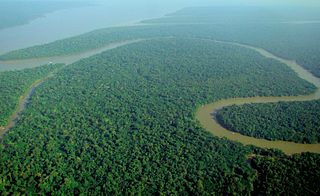
The Amazon rainforest, also called Amazon jungle or Amazonia, is a moist broadleaf tropical rainforest in the Amazon biome that covers most of the Amazon basin of South America. This basin encompasses 7,000,000 km2 (2,700,000 sq mi), of which 6,000,000 km2 (2,300,000 sq mi) are covered by the rainforest. This region includes territory belonging to nine nations and 3,344 formally acknowledged indigenous territories.

Forestry is the science and craft of creating, managing, planting, using, conserving and repairing forests and woodlands for associated resources for human and environmental benefits. Forestry is practiced in plantations and natural stands. The science of forestry has elements that belong to the biological, physical, social, political and managerial sciences. Forest management plays an essential role in the creation and modification of habitats and affects ecosystem services provisioning.

Nottingham Forest Football Club is a professional association football club based in West Bridgford, Nottingham, England. The club competes in the Premier League, the top tier of English football.

Portaferry is a small town in County Down, Northern Ireland, at the southern end of the Ards Peninsula, near the Narrows at the entrance to Strangford Lough. It is home to the Exploris aquarium and is well known for the annual Gala Week Float Parade. It hosts its own small Marina, the Portaferry Marina. The Portaferry – Strangford Ferry service operates daily at 30-minute intervals between the villages of Portaferry and Strangford, less than 1500 metres apart, conveying about 500,000 passengers per annum. It had a population of 2,514 people in the 2011 Census. The town is located within the Barony of Ards Upper.

Forest Steven Whitaker is an American actor, producer and director. He is the recipient of various accolades, including an Academy Award, a Golden Globe Award, a British Academy Film Award, and two Screen Actors Guild Awards.

An old-growth forest is a forest that has developed over a long period of time without disturbance. Due to this, old-growth forests exhibit unique ecological features. The Food and Agriculture Organization of the United Nations defines primary forests as naturally regenerated forests of native tree species where there are no clearly visible indications of human activity and the ecological processes are not significantly disturbed. One-third of the world's forests are primary forests. Old-growth features include diverse tree-related structures that provide diverse wildlife habitats that increases the biodiversity of the forested ecosystem. Virgin or first-growth forests are old-growth forests that have never been logged. The concept of diverse tree structure includes multi-layered canopies and canopy gaps, greatly varying tree heights and diameters, and diverse tree species and classes and sizes of woody debris.

Sundarbans is a mangrove area in the delta formed by the confluence of the Ganges, Brahmaputra and Meghna Rivers in the Bay of Bengal. Spread across parts of India and Bangladesh, this forest is the largest mangrove forest in the world. It spans the area from the Baleswar River in Bangladesh's division of Khulna to the Hooghly River in India's state of West Bengal. It comprises closed and open mangrove forests, land used for agricultural purpose, mudflats and barren land, and is intersected by multiple tidal streams and channels. Sundarbans is home to the world's largest area of mangrove forests. Four protected areas in the Sundarbans are enlisted as UNESCO World Heritage Sites, viz. Sundarbans West (Bangladesh), Sundarbans South (Bangladesh), Sundarbans East (Bangladesh) and Sundarbans National Park (India).

The Sidlaws are a range of hills in the counties of Perthshire and Angus in Scotland that extend for 30 miles (45 km) from Kinnoull Hill, near Perth, northeast to Forfar. A continuation of the Ochils, they separate Strathmore to the north from the Carse of Gowrie on the shore of the Tay.
Events during the year 1985 in Northern Ireland.
Castleward Opera was a Northern Ireland opera company which staged an annual opera festival at Castle Ward, a National Trust house near Strangford in County Down. It was founded in 1985 by Ian Urwin and Jack Smith, with performances taking place in a converted stable on the grounds of the castle. Following the cut to its core funding by the Arts Council of Northern Ireland, the festival saw its final opera performances in June 2009 and in September 2010 held two gala farewell concerts of highlights from the company's 25-year history. In January 2010, a new venture, supported by the Arts Council of Northern Ireland, was proposed—Opera Company NI—which the Arts Council said would "incorporate the best resources from Castleward Opera and Opera Fringe".

Montane ecosystems are found on the slopes of mountains. The alpine climate in these regions strongly affects the ecosystem because temperatures fall as elevation increases, causing the ecosystem to stratify. This stratification is a crucial factor in shaping plant community, biodiversity, metabolic processes and ecosystem dynamics for montane ecosystems. Dense montane forests are common at moderate elevations, due to moderate temperatures and high rainfall. At higher elevations, the climate is harsher, with lower temperatures and higher winds, preventing the growth of trees and causing the plant community to transition to montane grasslands and shrublands or alpine tundra. Due to the unique climate conditions of montane ecosystems, they contain increased numbers of endemic species. Montane ecosystems also exhibit variation in ecosystem services, which include carbon storage and water supply.
Ballyculter is a civil parish in County Down, Northern Ireland. It is situated in the historic barony of Lecale Lower.
