
Pyramid Lake is the geographic sink of the basin of the Truckee River, 40 mi (64 km) northeast of Reno, Nevada, United States.

County Cavan is a county in Ireland. It is in the province of Ulster and is part of the Border Region. It is named after the town of Cavan and is based on the historic Gaelic territory of East Breffny (Bréifne). Cavan County Council is the local authority for the county, which had a population of 76,176 at the 2016 census.

Hemlock Lake is one of the minor Finger Lakes. It is mostly located in Livingston County, New York, south of Rochester, with a portion overlapping into Ontario County. Hemlock is a translation of the Seneca name for the lake, O-neh-da Te-car-ne-o-di.

Rathdowney or Rathdowny is a town in southwest County Laois, Ireland. It lies some 32 km southwest of Portlaoise in the Irish Midlands, at the point where the R433 regional road from Abbeyleix to Templemore is crossed by the R435 from Borris-in-Ossory to Johnstown. The R433 provides access for Rathdowney to the Dublin-Cork M8 motorway, while the R435 links the town to the Dublin-Limerick M7. According to the 2011 census the population stands at 1,208.

The Apalachicola National Forest is the largest U.S. National Forest in the state of Florida. It encompasses 632,890 acres and is the only national forest located in the Florida Panhandle. The National Forest provides water and land-based outdoors activities such as off-road biking, hiking, swimming, boating, hunting, fishing, horse-back riding, and off-road ATV usage.

Superior National Forest, part of the United States National Forest system, is located in the Arrowhead Region of the state of Minnesota between the Canada–United States border and the north shore of Lake Superior. The area is part of the greater Boundary Waters region along the border of Minnesota and the Canadian province of Ontario, a historic and important thoroughfare in the fur trading and exploring days of New France and British North America.

Forest Hills is a neighborhood partially within the city limits of Tampa, Florida, United States, with the northern portion located in unincorporated Hillsborough County near Lake Magdalene. In 1926 a golf course and club house was built there. In 1949, "Babe" Zaharias bought the clubhouse and golf course, and may have lived in the clubhouse for a time. She moved to a house nearby in 1954. In 1956, she died of cancer in Galveston, Texas and the course closed.
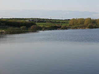
Llyn Alaw is a man-made reservoir on Anglesey, North Wales managed by Dŵr Cymru / Welsh Water. It is a shallow lake and was built in 1966. It is a Site of Special Scientific Interest and a destination for over-wintering birds.
Franklin Pierce Lake, also known as Jackman Reservoir, is a 483-acre (2.0 km2) reservoir located in Hillsborough County in southern New Hampshire, United States, in the towns of Hillsborough and Antrim. It is named for Franklin Pierce, the 14th president of the United States, who was born in Hillsborough. The lake impounds the North Branch of the Contoocook River and lies within the Merrimack River watershed.

Island Pond is a 532-acre (215 ha) water body located in Rockingham County in southern New Hampshire, in the towns of Derry, Hampstead and Atkinson. The pond is near the head of the Spicket River watershed, which feeds the Merrimack River in Lawrence, Massachusetts. The pond was formed from the merger of two smaller bodies of water in 1878, when a dam raised the water level by 8.5 feet.

Nubanusit Lake is a 718-acre (2.91 km2) lake located on the border between Cheshire and Hillsborough counties in southwestern New Hampshire, United States, in the towns of Nelson and Hancock. The outlet of the lake is Nubanusit Brook, a tributary of the Contoocook River in the Merrimack River drainage basin.

The Thousand Lakes Wilderness is located within the southern portion of the Cascade Range in northeastern California. The 16,335-acre (66 km2) wilderness was established in 1964 with the passage of the Wilderness Act and is administered by Lassen National Forest. The area lies within Shasta County, midway between the town of Burney and Lassen Volcanic National Park.

Olallie Butte is a steep-sided shield volcano in the Cascade Range of the northern part of the U.S. state of Oregon. It is the largest volcano and highest point in the 50-mile (80 km) distance between Mount Hood and Mount Jefferson. Located just outside the Olallie Scenic Area, it is surrounded by more than 200 lakes and ponds fed by runoff, precipitation, and underground seepage, which are popular spots for fishing, boating, and swimming. The butte forms a prominent feature in the Mount Jefferson region and is usually covered with snow during the winter and spring seasons.

Rathmichael is a suburb in the south-east of Dublin in the county of Dún Laoghaire–Rathdown. It is situated west of Shankill from which it is separated by the M50/M11 motorways. It is also a civil parish in the barony of Rathdown.
Raheen is a townland and village in County Wexford, Ireland. It lies 27 km from Wexford, 11 km from New Ross, and 23 km from Enniscorthy.

Indian Lake is a 12-mile (19 km) long, 4,255-acre (1,722 ha) lake with a southwest to northeast orientation in the towns of Indian Lake and Lake Pleasant in Hamilton County, in the Adirondack Park of New York State, in the United States. The hamlet of Indian Lake is located 2 miles (3.2 km) north of the north end of Indian Lake. New York State Route 30 runs along the west shore of the lake. Most of the shore is part of the Forest Preserve. Indian Lake is fed by the Jessup River, and drains through the Indian River into Lake Abanakee, and from there through the Indian River to the Hudson River.
Drumlough is a village/townland in County Down, Northern Ireland, southwest of Rathfriland, and is located in the civil parish of Drumgath.

Rathborney, sometimes Rathbourney, is a civil parish in the Barony of Burren in County Clare, Ireland.

Rath is a civil parish in the barony of Inchiquin in County Clare, Ireland.


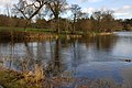 The lake, Hillsborough forest
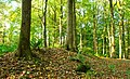 The earth bank shown is part of what remains of the rath
