
County Down is one of the six counties of Northern Ireland, one of the nine counties of Ulster and one of the traditional thirty-two counties of Ireland. It covers an area of 961 sq mi (2,490 km2) and has a population of 531,665. It borders County Antrim to the north, the Irish Sea to the east, County Armagh to the west, and County Louth across Carlingford Lough to the southwest.

Warrenpoint is a small port town and civil parish in County Down, Northern Ireland. It sits at the head of Carlingford Lough, south of Newry, and is separated from the Republic of Ireland by a narrow strait. The town is beside the village of Rostrevor and is overlooked by the Mournes and Cooley Mountains. Warrenpoint sprang up within the townland of Ringmackilroy, and is locally nicknamed "The Point".

Rostrevor is a village and townland in County Down, Northern Ireland. It lies at the foot of Slieve Martin on the coast of Carlingford Lough, near Warrenpoint. The Kilbroney River flows through the village and Rostrevor Forest is nearby. It is within Newry, Mourne and Down District.

Kilkeel is a small town, civil parish and townland in County Down, Northern Ireland. It is the southernmost town in Northern Ireland. It lies within the historic barony of Mourne. Kilkeel town is the main fishing port on the Down coast, and its harbour is home to the largest fishing fleet in Northern Ireland. It had a population of 6,541 people at the 2011 Census. The town contains the ruins of a 14th-century church and fort, winding streets and terraced shops. It lies just south of the Mourne Mountains.

The Mourne Mountains, also called the Mournes or Mountains of Mourne, are a granite mountain range in County Down in the south-east of Northern Ireland. They include the highest mountains in Northern Ireland, the highest of which is Slieve Donard at 850 m (2,790 ft). The Mournes are designated an Area of Outstanding Natural Beauty and it has been proposed to make the area Northern Ireland's first national park. The area is partly owned by the National Trust and sees many visitors every year. The Mourne Wall crosses fifteen of the summits and was built to enclose the catchment basin of the Silent Valley and Ben Crom reservoirs.
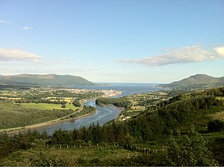
Carlingford Lough is a glacial fjord or sea inlet in northeastern Ireland, forming part of the border between Northern Ireland to the north and the Republic of Ireland to the south. On its northern shore is County Down, the Mourne Mountains, and the town of Warrenpoint; on its southern shore is County Louth, the Cooley Mountains and the village of Carlingford. The Newry River flows into the loch from the northwest.

Woodford is a village in the south-east of County Galway, Ireland. It is situated between the River Shannon and the Slieve Aughty mountains.

Portumna is a market town in the south-east of County Galway, Ireland, on the border with and linked by a bridge to County Tipperary. The town is located to the west of the point where the River Shannon enters Lough Derg. This historic crossing point over the River Shannon between counties Tipperary and Galway has a long history of bridges and ferry crossings. On the south-western edge of the town lie Portumna Castle and Portumna forest park.

Carlingford is a coastal town and civil parish in northern County Louth, Ireland. For the purposes of local government, the town is part of the Dundalk Municipal District. It is situated on the southern shore of Carlingford Lough with Slieve Foy mountain as a backdrop, sometimes known as Carlingford Mountain. It is the main town on the Cooley Peninsula. Located on the R176/R173 roads between Greenore and Omeath village, Carlingford is approximately 27 km north east from Dundalk, 90 km north of Dublin and 11 km south of the border with Northern Ireland. Carlingford won the Irish Tidy Towns Competition in 1988.

Slieve Foy or Slieve Foye is a mountain on the Cooley Peninsula in Louth, Ireland. It rises to 589 metres (1,932 ft), making it the highest of the Cooley Mountains and the highest in Louth. It overlooks Carlingford Lough and the village of Carlingford, and is sometimes called Carlingford Mountain.

Newry River and River Clanrye are names for one of the rivers of Ireland. The river passes through the city of Newry and empties into Carlingford Lough near Warrenpoint.
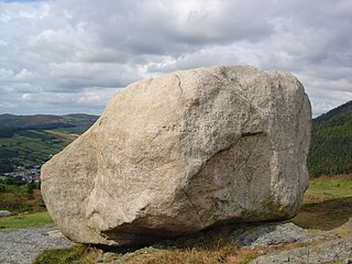
Cloughmore or Cloghmore, known locally as "The Big Stone", is a huge granite boulder perched on a mountainside almost 1,000 feet (300 m) above the village of Rostrevor, County Down, Northern Ireland. It sits on the slopes of Slieve Martin in Kilbroney Park, overlooking Rostrevor Forest, Carlingford Lough and the Cooley Peninsula. It is popular destination for visitors, and is part of a National Nature Reserve and Area of Special Scientific Interest.

Greencastle is a castle in County Down, Northern Ireland. While it dates mainly from the 13th century, it had substantial 15th- and 16th-century alterations. It was originally surrounded by outer rectangular walls with four corner towers. It is likely to have been built by Hugh de Lacy, along with Carlingford Castle on the opposite side of Carlingford Lough, to guard the narrow entry channel to the Lough, and the ferry crossing between the two.

Killowen, alternatively spelt Cill Abhainn is a small village in County Down, Northern Ireland. It is near Rostrevor and on the shore of Carlingford Lough. In the 2001 Census it had a population of 159 people. It lies within the Newry and Mourne District Council area.
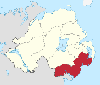
Newry, Mourne and Down is a local government district in Northern Ireland that was created on 1 April 2015 by merging Newry and Mourne District and Down District. It covers most of the southeastern part of Northern Ireland. The local authority is Newry, Mourne and Down District Council.
Saint Brónach was a 6th-century holy woman from Ireland, the reputed founder and patron saint of Cell Brónche, now Kilbroney, in County Down, Northern Ireland.

Lough Mourne is a freshwater lake in the northwest of Ireland. It is located in County Donegal, near the border with County Tyrone.

Kilbroney Park is a park near Rostrevor in Northern Ireland. Formerly a country estate, it was visited by William Makepeace Thackeray, Charles Dickens and Seamus Heaney and may have been the inspiration for Narnia in the writings of C. S. Lewis. It came into the ownership of the Bowes-Lyon family, and the future Queen Elizabeth II and Princess Margaret holidayed there as children. The park has been run by Newry, Mourne and Down District Council since 1977 and features a children's play area, tennis courts and a cafe. It has a large collection of rare and historic trees, including "Old Homer", a holm oak that was voted Northern Ireland's Tree of the Year in 2016. A glacial erratic in the park is connected with the legend of the giant Finn Mac Cool.

The Newry, Warrenpoint and Rostrevor Railway (NW&RR) was a former railway line linking Newry and the port of Warrenpoint on the Carlingford Lough inlet in Ireland, and the company operating it. The railway was absorbed into the Great Northern Railway of Ireland in 1886 and the line closed in 1965.


