The following is an incomplete list of Parks and Open Spaces in Northern Ireland.
The following is an incomplete list of Parks and Open Spaces in Northern Ireland.

County Armagh is one of the six counties of Northern Ireland and one of the traditional thirty-two counties of Ireland. It is located in the province of Ulster and adjoins the southern shore of Lough Neagh. It borders the Northern Irish counties of Tyrone to the west and Down to the east. The county borders Louth and Monaghan to the south and southwest, which are in the Republic of Ireland. It is named after its county town, Armagh, which derives from the Irish Ard Mhacha, meaning "Macha's height". Macha was a sovereignty goddess in Irish mythology and is said to have been buried on a wooded hill around which the town of Armagh grew. County Armagh is colloquially known as the "Orchard County" because of its many apple orchards.
Nature reserves in Northern Ireland, are designated and maintained by the Northern Ireland Environment Agency.

County Down is one of the six counties of Northern Ireland, one of the nine counties of Ulster and one of the traditional thirty-two counties of Ireland. It covers an area of 961 sq mi (2,490 km2) and has a population of 552,261. It borders County Antrim to the north, the Irish Sea to the east, County Armagh to the west, and County Louth across Carlingford Lough to the southwest.

Portadown is a town in County Armagh, Northern Ireland. The town sits on the River Bann in the north of the county, about 24 miles (39 km) southwest of Belfast. It is in the Armagh City, Banbridge and Craigavon Borough Council area and had a population of about 32,000 at the 2021 Census. For some purposes, Portadown is treated as part of the "Craigavon Urban Area", alongside Craigavon and Lurgan.

Rostrevor is a village and townland in County Down, Northern Ireland. It lies at the foot of Slieve Martin on the coast of Carlingford Lough, near Warrenpoint. The Kilbroney River flows through the village and Rostrevor Forest is nearby. 7.5 miles (12 km) south-east of Newry, the village is within the Newry, Mourne and Down local government district.
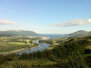
Carlingford Lough is a glacial fjord or sea inlet in northeastern Ireland, forming part of the border between Northern Ireland to the north and the Republic of Ireland to the south. On its northern shore is County Down, the Mourne Mountains, and the town of Warrenpoint; on its southern shore is County Louth, the Cooley Mountains and the village of Carlingford. The Newry River flows into the loch from the northwest.

The A2 is a major road in Northern Ireland, a considerable length of which is often referred to the Antrim Coast Road because much of it follows the scenic coastline of County Antrim; other parts of the road follow the coasts in Counties Down and Londonderry.
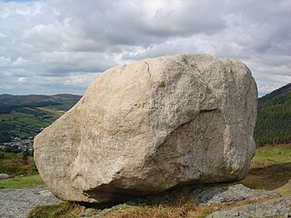
Cloughmore or Cloghmore, known locally as "The Big Stone", is a huge granite boulder perched on a mountainside almost 1,000 feet (300 m) above the village of Rostrevor, County Down, Northern Ireland. It sits on the slopes of Slieve Martin in Kilbroney Park, overlooking Rostrevor Forest, Carlingford Lough and the Cooley Peninsula. It is popular destination for visitors, and is part of a National Nature Reserve and Area of Special Scientific Interest.
Maghery is a small village and townland in County Armagh, Northern Ireland. It lies on the southwest shore of Lough Neagh, near Derrywarragh Island, in the northwest corner of the county. As it sits between the estuaries of the rivers Blackwater and Bann, Maghery was of strategic significance in the past.
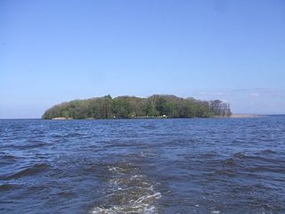
Coney Island is an island in Lough Neagh, Northern Ireland. It is about 1 km offshore from Maghery in County Armagh, is thickly wooded and of nearly 9 acres (36,000 m2) in area. It lies between the mouths of the River Blackwater and the River Bann in the south-west corner of Lough Neagh. Boat trips to the island are available at weekends from Maghery Country Park or Kinnego Marina. The island is owned by the National Trust and managed on their behalf by Armagh City, Banbridge and Craigavon Borough Council. Coney Island Flat is a rocky outcrop adjacent to the island. Although Samuel Lewis called Coney Island the only island in County Armagh, Armagh's section of Lough Neagh also includes Croaghan Island, as well as the marginal cases of Padian and Derrywarragh Island.

Oneilland is the name of a former barony in County Armagh, present-day Northern Ireland. It covers the northern area of the county bordering the south-eastern shoreline of Lough Neagh. At some stage the barony was divided into Oneilland East and Oneilland West.
Oxford Island is a National Nature Reserve and public recreation site on the southern shores of Lough Neagh at Lurgan, County Armagh. The site covers 282 acres and is owned and maintained by Armagh City, Banbridge and Craigavon Borough Council. Much of the area is designated as a National Nature Reserve due to its wide variety of natural habitats. The purpose of all work on the island is to maintain biodiversity and to provide a recreation area for everyone.
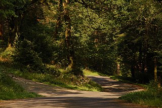
Rostrevor Forest is located near the village of Rostrevor, County Down, Northern Ireland. It lies between the Mourne Mountains and Carlingford Lough, in the Mourne Area of Outstanding Natural Beauty. The first trees, primarily sitka spruce, douglas fir and pine, were planted in 1931. The Forest Service carries out felling in the forest and replants trees with wildlife conservation in mind. Animal species found in the forest include red and grey squirrels, foxes, badgers, jays and sparrow hawks.

Kilbroney Park is a park near Rostrevor in Northern Ireland. Formerly a country estate, it was visited by William Makepeace Thackeray, Charles Dickens and Seamus Heaney and may have been the inspiration for Narnia in the writings of C. S. Lewis. It came into the ownership of the Bowes-Lyon family, and the future Queen Elizabeth II and Princess Margaret holidayed there as children. The park has been run by Newry, Mourne and Down District Council since 1977 and features a children's play area, tennis courts and a cafe. It has a large collection of rare and historic trees, including "Old Homer", a holm oak that was voted Northern Ireland's Tree of the Year in 2016. A glacial erratic in the park is connected with the legend of the giant Finn Mac Cool.