
County Armagh is one of the six counties of Northern Ireland and one of the traditional thirty-two counties of Ireland. It is located in the province of Ulster and adjoins the southern shore of Lough Neagh. It borders the Northern Irish counties of Tyrone to the west and Down to the east. The county borders Louth and Monaghan to the south and southwest, which are in the Republic of Ireland. It is named after its county town, Armagh, which derives from the Irish Ard Mhacha, meaning "Macha's height". Macha was a sovereignty goddess in Irish mythology and is said to have been buried on a wooded hill around which the town of Armagh grew. County Armagh is colloquially known as the "Orchard County" because of its many apple orchards.

County Down is one of the six counties of Northern Ireland, one of the nine counties of Ulster and one of the traditional thirty-two counties of Ireland. It covers an area of 961 sq mi (2,490 km2) and has a population of 552,261. It borders County Antrim to the north, the Irish Sea to the east, County Armagh to the west, and County Louth across Carlingford Lough to the southwest.
Lurgan is a town in County Armagh, Northern Ireland, near the southern shore of Lough Neagh and roughly 18 miles (29 km) southwest of Belfast. The town is linked to Belfast by both the M1 motorway and the Belfast–Dublin railway line. Lurgan had a population of about 28,634 at the 2021 UK census, and falls within the Armagh, Banbridge and Craigavon district. For certain purposes, Lurgan is treated as part of the "Craigavon Urban Area", along with neighbouring Craigavon and Portadown.

Portadown is a town in County Armagh, Northern Ireland. The town sits on the River Bann in the north of the county, about 24 mi (39 km) southwest of Belfast. It is in the Armagh City, Banbridge and Craigavon Borough Council area and had a population of about 32,000 at the 2021 Census. For some purposes, Portadown is treated as part of the "Craigavon Urban Area", alongside Craigavon and Lurgan.

Lough Neagh is a freshwater lake in Northern Ireland and is the largest lake on the island of Ireland and in the United Kingdom. It has a surface area of 151 square miles and is about 19 miles (31 km) long and 9 miles (14 km) wide. According to Northern Ireland Water, it supplies 40.7% of Northern Ireland's drinking water. Its main inflows are the Upper River Bann and Blackwater, and its main outflow is the Lower Bann. There are several small islands, including Ram's Island, Coney Island and Derrywarragh Island. The lake bed is owned by the 12th Earl of Shaftesbury and the lake is managed by Lough Neagh Partnership. Its name comes from Irish Loch nEachach, meaning "Eachaidh's lake".

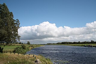
The River Bann is the longest river in Northern Ireland, its length, Upper and Lower Bann combined, being 129 km (80 mi). However, the total length of the River Bann, including its path through the 30 km (19 mi) long Lough Neagh is 159 km (99 mi). Another length of the River Bann given is 90 mi. The river winds its way from the southeast corner of Ulster to the northwest coast, pausing in the middle to widen into Lough Neagh. The River Bann catchment has an area of 5,775 km2. The River Bann has a mean discharge rate of 92 m3/s. According to C. Michael Hogan, the Bann River Valley is a settlement area for some of the first human arrivals in Ireland after the most recent glacial retreat.
Craigavon Borough Council was a local council in counties Armagh, Down and Antrim, in Northern Ireland. It merged with Armagh City and District Council and Banbridge District Council in May 2015 under local government reorganisation in Northern Ireland to become Armagh, Banbridge and Craigavon District Council.

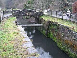
The Newry Canal is an abandoned canal in Northern Ireland. Opened in 1742, it was built to link the Tyrone coalfields to the Irish Sea. The navigable route ran from Lough Neagh via the Upper Bann river to Portadown, then approximately 20 miles from Portadown via the canal proper to Newry, terminating in the Albert Basin.
Derrymacash is a small village and townland in County Armagh, Northern Ireland. It is about four miles west of Lurgan, between the M1 motorway and Lough Neagh. It had a population of 629 in the 2001 Census.
Derryadd is a hamlet and townland in County Armagh, Northern Ireland. It is within the Armagh City, Banbridge and Craigavon Borough Council area, on the southern shores of Lough Neagh. In the 2001 Census it had a population of 201 people.
Maghery is a small village and townland in County Armagh, Northern Ireland. It lies on the southwest shore of Lough Neagh, near Derrywarragh Island, in the northwest corner of the county. As it sits between the estuaries of the rivers Blackwater and Bann, Maghery was of strategic significance in the past.
The Birches is a small village in northern County Armagh, Northern Ireland. It is 6 miles northwest of Portadown, close to junction 12 on the M1 Motorway and to the southern shore of Lough Neagh. In the 2001 Census it had a population of 150. It is within the Armagh City, Banbridge and Craigavon council area.

Derrymore is a small village and townland in County Armagh, Northern Ireland. In the 2001 Census it had a population of 243 people. It lies on the shores of Lough Neagh, within the Armagh City, Banbridge and Craigavon Borough Council area.

Derrywarragh Island is a boulder clay island on Lough Neagh, Northern Ireland. It is linked by a bridge to Maghery, County Armagh. The island is approximately 13 kilometres (8 mi) northwest of Portadown. Most of the island is wet grassland. There are also areas of wet woodland, marshes and swamps. The island is also regularly the home of wintering and breeding birds.
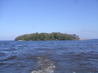
Coney Island is an island in Lough Neagh, Northern Ireland. It is about 1 km offshore from Maghery in County Armagh, is thickly wooded and of nearly 9 acres (36,000 m2) in area. It lies between the mouths of the River Blackwater and the River Bann in the south-west corner of Lough Neagh. Boat trips to the island are available at weekends from Maghery Country Park or Kinnego Marina. The island is owned by the National Trust and managed on their behalf by Armagh City, Banbridge and Craigavon Borough Council. Coney Island Flat is a rocky outcrop adjacent to the island. Although Samuel Lewis called Coney Island the only island in County Armagh, Armagh's section of Lough Neagh also includes Croaghan Island, as well as the marginal cases of Padian and Derrywarragh Island.
Bannfoot is a small village in the townland of Derryinver, County Armagh, Northern Ireland. It sits where the Upper Bann flows into Lough Neagh.

Armagh City, Banbridge and Craigavon is a local government district in Northern Ireland. The district was created as Armagh, Banbridge and Craigavon on 1 April 2015 by merging the City and District of Armagh, Banbridge District and most of the Borough of Craigavon. The word "City" was added to the name on 24 February 2016, to reflect Armagh's city status. The local authority is Armagh City, Banbridge and Craigavon Borough Council.

Maghery Country Park is a park in the village of Maghery, County Armagh, Northern Ireland, on the shores of Lough Neagh. It covers 30 acres (120,000 m2) and includes five km of woodland walks and picnic areas and is used for birdwatching, fishing, and walking. Coney Island lies one km off shore and boat trips are available from the park at weekends. It is an important local amenity and tourist attraction and is managed by Armagh City, Banbridge and Craigavon Borough Council.
The Lagan Canal was a 44-kilometre (27 mi) canal built to connect Belfast to Lough Neagh. The first section, which is a river navigation, was opened in 1763, and linked Belfast to Lisburn. The second section from Lisburn to Lough Neagh includes a small amount of river navigation, but was largely built as a canal. At its peak it was one of the most successful of the Irish canals, but ultimately it was unable to compete with road and rail transport, and the two sections were closed in 1954 and 1958. The central section from Sprucefield to Moira was destroyed by the construction of the M1 motorway in the 1960s. Responsibility for most of its remains passed first to the Department of Agriculture and then to the Department of Culture, Arts and Leisure, although the section between Aghalee Bridge and Lough Neagh, including the final ten locks, passed into private ownership. There is an active campaign to re-open the canal, including reinstatement of the central section.