Newtownards is a town in County Down, Northern Ireland. It lies at the most northern tip of Strangford Lough, 10 miles (16 km) east of Belfast, on the Ards Peninsula. It is in the civil parish of Newtownards and the historic baronies of Ards Lower and Castlereagh Lower. Newtownards is in the Ards and North Down Borough. The population was 29,677 in the 2021 Census.

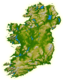
County Down is one of the six counties of Northern Ireland, one of the nine counties of Ulster and one of the traditional thirty-two counties of Ireland. It covers an area of 961 sq mi (2,490 km2) and has a population of 552,261. It borders County Antrim to the north, the Irish Sea to the east, County Armagh to the west, and County Louth across Carlingford Lough to the southwest.
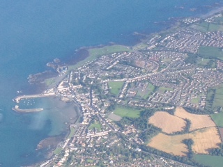
Bangor is a city and seaside resort in County Down, Northern Ireland, on the southern side of Belfast Lough. It is within the Belfast metropolitan area and is 13 miles (22 km) east of Belfast city centre, to which it is linked by the A2 road and the Belfast–Bangor railway line. The population was 64,596 at the 2021 Census. Bangor was granted city status in 2022, becoming Northern Ireland's sixth city.
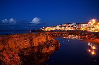
Donaghadee is a small town in County Down, Northern Ireland. It lies on the northeast coast of the Ards Peninsula, about 18 miles (29 km) east of Belfast and about six miles (10 km) south east of Bangor. It is in the civil parish of Donaghadee and the historic barony of Ards Lower. It had a population of 6,869 people in the 2011 Census.
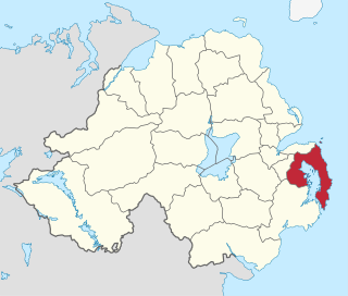
Ards was a local government district in Northern Ireland with the status of borough. It was one of twenty-six districts formed on 1 October 1973, and had its headquarters in Newtownards. It was merged with neighbouring North Down on 1 May 2015 to form the new Borough of Ards and North Down. Other towns in the defunct Borough included Portaferry, Comber, and Donaghadee, and the population of the area was 78,078 according to the 2011 census.

Dundonald is a large settlement and civil parish in County Down, Northern Ireland, United Kingdom. It lies east of Belfast and is often considered a suburb of the city. It is home to the Ulster Hospital, Dundonald International Ice Bowl, Dundonald Omnipark, has a Park and Ride facility for the Glider, access to the Comber Greenway and several housing developments. John de Courcey established a keep including a motte-and-bailey in the 12th century. This is known as Moat Park and can be accessed from Church Green, Comber Road and the Upper Newtownards Road.
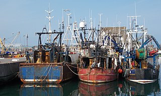
Portavogie is a village, townland and fishing port in County Down, Northern Ireland. It lies within the Ards and North Down Borough and is the easternmost settlement in Ireland. It had a population of 2,122 people in the 2011 Census.

Ballywalter is a village or townland and civil parish in County Down, Northern Ireland. It is on the east coast of the Ards Peninsula between Donaghadee and Ballyhalbert. Ballywalter was formerly known as Whitkirk as far back as the 12th century. It had a population of 2,027 people in the 2011 census.
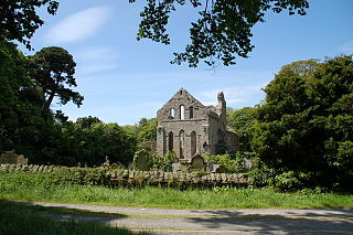
Greyabbey or Grey Abbey is a small village, townland and civil parish located on the eastern shores of Strangford Lough, on the Ards Peninsula in County Down, Northern Ireland.

Kirkistown Castle is a castle situated near Cloghy, County Down, Northern Ireland. The tower house and bawn is a state care historic monument in the townland of Kirkistown, in Ards and North Down Borough.

Clandeboye or Clannaboy was a kingdom of Gaelic Ireland, comprising what is now south County Antrim, north County Down, and the barony of Loughinsholin. The entity was relatively late in appearance and is associated partly with the Gaelic resurgence of the High Middle Ages. The O'Neill Clandeboy who reigned in the territory descended from Hugh Boy O'Neill, a king of Tyrone. His descendants took advantage of the demise of the Earldom of Ulster during the latter 14th century and seized vast portions of territory. Clandeboye's main seats of power were Shane's Castle and Castle Reagh.

Ballyblack is a rural area in the Ards Peninsula of County Down, Northern Ireland, approximately 4 miles southeast of the town of Newtownards. Located in the barony of Ards Lower, Ballyblack townland spans the civil parish of Greyabbey and civil parish of Newtownards. According to PlacenamesNI.org, the name Ballyblack originates from "Baile Bhleaic" meaning Black's townland.
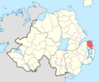
Ards Lower, alternatively known as North Ards, is a barony in County Down, Northern Ireland. It lies on the northern half of the Ards Peninsula in the north-east of the county, with the Irish Sea to its east and Strangford Lough to its south-west. It is bordered by two other baronies: Ards Upper to the south; and Castlereagh Lower to the west.

Ards is the name of several different historical territorial divisions all located on the Ards Peninsula in modern-day County Down, Northern Ireland.
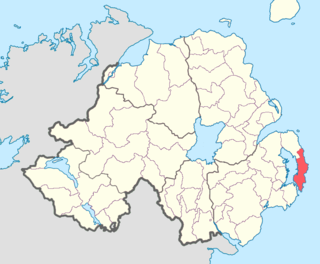
Ards Upper is a barony in County Down, Northern Ireland. It lies on the southern half of the Ards Peninsula in the east of the county, with the Irish Sea to its east and Strangford Lough to its west. It is bordered by two other baronies: Ards Lower to the north; and Lecale Lower just across the mouth of Strangford Lough to the south.

Lecale is a peninsula in the east of County Down, Northern Ireland. It lies between Strangford Lough and Dundrum Bay. In the Middle Ages it was a district or túath in the Gaelic Irish kingdom of Ulaid, then became a county in the Anglo-Norman Earldom of Ulster. Later it became a barony, which was split into Lecale Lower and Lecale Upper by 1851. Its largest settlement is the town of Downpatrick. Other settlements include Ardglass, Killough and Strangford. The peninsula has a high concentration of tower houses. Much of it is part of the 'Strangford and Lecale' Area of Outstanding Natural Beauty.
Bangor is a civil and ecclesiastical parish in County Down, Northern Ireland. It is located in the north of the Ards Peninsula, consisting of 30 townlands, twenty-two and a half of which lie in the barony of Ards Lower, with seven and a half lying within that of Castlereagh Lower. Its ancient monastery was of ecclesiastical importance.

Castlereagh Lower is a historic barony in County Down, Northern Ireland. It was created by 1841 with the division of Castlereagh into two. The barony roughly matches the former Gaelic territory of Uí Blathmaic, anglicized Blathewic. It is bordered by three other baronies: Ards Lower to the east; Dufferin to the south; and Castlereagh Upper to the west and south-west. Castlereagh Lower is also bounded by Belfast Lough to the north and Strangford Lough to the south-east.