
County Down is one of the six counties of Northern Ireland, one of the nine counties of Ulster and one of the traditional thirty-two counties of Ireland. It covers an area of 961 sq mi (2,490 km2) and has a population of 531,665. It borders County Antrim to the north, the Irish Sea to the east, County Armagh to the west, and County Louth across Carlingford Lough to the southwest.

Lough Neagh is a freshwater lake in Northern Ireland and is the largest lake on the island of Ireland and in the United Kingdom. It has a surface area of 151 square miles and supplies 40% of Northern Ireland's water. Its main inflows come from the Upper River Bann and River Blackwater, and its main outflow is the Lower River Bann. Its name comes from Irish Loch nEachach[ˌl̪ˠɔx ˈn̠ʲahəx], meaning "Eachaidh's lake". The lough is owned by the Earl of Shaftesbury and managed by Lough Neagh Partnership Ltd.

Lough Erne is the name of two connected lakes in County Fermanagh, Northern Ireland. It is the second-biggest lake system in Northern Ireland and Ulster, and the fourth biggest in Ireland. The lakes are widened sections of the River Erne, which flows north and then curves west into the Atlantic. The smaller southern lake is called the Upper Lough as it is higher up the river. The bigger northern lake is called the Lower Lough or Broad Lough. The town of Enniskillen lies on the short stretch of river between the lakes. The lake has more than 150 islands, along with many coves and inlets. The River Erne is 80 miles (129 km) long and drains an area of about 1,680 square miles (4,350 km2).

Mountshannon is a village in east County Clare, Ireland. It is part of the Catholic parish Mountshannon-Whitegate. The village is on the western shore of Lough Derg, north of Killaloe. Mountshannon won the Irish Tidy Towns Competition in 1981.

Lough Ree, translated to English as King's Lake or King Lake, is a lake in the midlands of Ireland, the second of the three major lakes on the River Shannon. Lough Ree is the second largest lake on the Shannon after Lough Derg. The other two major lakes are Lough Allen to the north, and Lough Derg to the south. There are also several minor lakes along the length of the river. The lake serves as a border between the counties of Longford and Westmeath on the eastern side and County Roscommon in the province of Connacht on the western side. The lake is popular for fishing and boating. The lake supports a small commercial eel fishery and is locally famous for its eels on wheels truck. The town of Athlone is situated at the southern end of the lake, and has a harbour for boats going out on the lake. The small town of Lanesboro is at the northern end of the lake.

Lough Gill is a freshwater lough (lake) mainly situated in County Sligo, but partly in County Leitrim, in Ireland. Lough Gill provides the setting for William Butler Yeats' poem "The Lake Isle of Innisfree".
Ed Reavy (1897–1988) was an Irish-American musician and composer of numerous traditional Irish dance tunes. Born in the townland of Barnagrove, Knappagh, County Cavan, he emigrated to Philadelphia in 1912 where he settled in the Irish-American enclave of Corktown. Except for two visits back to Ireland, he remained in the Philadelphia area for the remainder of his life.

Boa Island is an island near the north shore of Lower Lough Erne in County Fermanagh, Northern Ireland. It is 25 km (16 mi) from Enniskillen town.

Lough MacNean is a large freshwater lake on the border between Northern Ireland and the Republic of Ireland.

Portmore Lough is a small lake in southwest County Antrim, Northern Ireland that drains water into nearby Lough Neagh. It is roughly circular and covers an area of 286 hectares. The Lough and its shoreland is designated a Ramsar site, a Special Protection Area (SPA) and an Area of Special Scientific Interest (ASSI). The lough is now part of a Royal Society for the Protection of Birds nature reserve.

Kilcoo is a small village and civil parish in County Down, Northern Ireland. It lies between Rathfriland and Castlewellan and is within the Newry, Mourne and Down District Council area. Kilcoo had a population 1415 people in the 2001 Census.
Kilcoo Owen Roes is a Gaelic Athletic Association club from Kilcoo, County Down, Northern Ireland.

Lough Beg is a small freshwater lake north of Lough Neagh in Northern Ireland. The lake is located on the border between County Londonderry and County Antrim. The Lower Bann flows into it from Lough Neagh at the southern end and continues on its route to the sea from the northern end. Church Island which is on the lake was the site of a pre-Viking monastery and during the summer it is normally reachable by foot. Due to the area's many rare plants and it being a stopping point for migrating birds the area was protected as the Lough Beg National Nature Reserve. It is one of the main Irish breeding areas for the scarce Garganey.
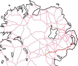
The A25 is the name given to the sections of the main route connecting Strangford with Castleblayney that lie in Northern Ireland. It is a road of regional importance, serving much of south Armagh and south Down. The road commences in the village of Strangford, on the shores of Strangford Lough, from which the Portaferry - Strangford Ferry service transports vehicles to Portaferry on the Ards peninsula. The entirety of the route is 61.2 miles, of which 54.5 miles are located north of the border, forming the A25 - the remaining 6.7 miles form the R182 in the Republic of Ireland.

Rosclogher is a barony in County Leitrim, Ireland.
Leitrim is a barony in Ireland that lies partly in County Galway and partly in County Clare. It is located in the south-eastern corner of County Galway and the north-eastern corner of County Clare. Prior to 1898, the entire barony was contained in County Galway. The Local Government (Ireland) Act 1898 split the barony: part of the barony was transferred to County Clare. Leitrim is bounded, clockwise from the southwest, by the Clare baronies of Tulla Upper and Tulla Lower; the Galway baronies of Loughrea to the west, Kilconnell to the north, and Longford to the east; and by Lough Derg to the south and southeast. It measures 20 miles (32 km) from north to south and 9.5 miles (15.3 km) from east to west.
This page is based on this
Wikipedia article Text is available under the
CC BY-SA 4.0 license; additional terms may apply.
Images, videos and audio are available under their respective licenses.


