Donegore is the name of a hill, a townland, a small cluster of residences, and a civil parish in the historic barony of Antrim Upper, County Antrim, Northern Ireland. Donegore lies approximately 5 miles (8 km) east of Antrim town. 154 acres of the townland lies in the civil parish of Grange of Nilteen.
Sixmilecross is a townland and small village in County Tyrone, Northern Ireland.

Ballywalter is a village or townland and civil parish in County Down, Northern Ireland. It is on the east coast of the Ards Peninsula between Donaghadee and Ballyhalbert. Ballywalter was formerly known as Whitkirk as far back as the 12th century. It had a population of 2,027 people in the 2011 census.

Drumbeg is a small village, townland and civil parish on the south bank of the River Lagan in County Down, Northern Ireland. The village is covered by the Lisburn City Council area and forms part of the suburban fringe of Belfast.

Killinchy is a townland and small village in County Down, Northern Ireland. It is two miles inland from the western shores of Strangford Lough in the Borough of Ards and North Down. It is situated in the townland of the same name, the civil parish of Killinchy and the historic barony of Dufferin. It had a population of 539 people in the 2011 Census.
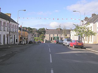
Richhill is a large village and townland in County Armagh, Northern Ireland. It lies between Armagh and Portadown. It had a population of 2,821 people in the 2011 Census.
Moneyslane is a small village and townland in County Down, Northern Ireland, on the main route from Castlewellan to Banbridge. In the 2001 Census, Moneyslane had a population of 147.

Ballylesson is a small village and townland in County Down, Northern Ireland. In the 2001 Census it had a population of 108 people. The village lies within the Lagan Valley Regional Park and the Lisburn City Council area.

Drumbo is a small village, townland and civil parish in County Down, Northern Ireland. It is about 6 miles (10 km) south of Belfast city centre, 3 miles (5 km) east of Lisburn and 3 miles (5 km) west of Carryduff. It is in the historic barony of Castlereagh Upper.

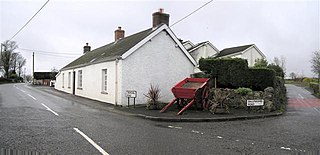
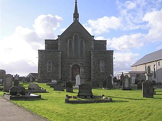
Drumlough is a village and townland in County Down, Northern Ireland, south of Hillsborough and east of Dromore. In the 2001 Census it had a population of 96 people. It is situated in the Lisburn City Council area. Locally significant buildings include Drumlough Presbyterian Church and manse, Rose Cottage, and an Orange Hall built in 1907.

Hillhall is a townland and non-nucleated village in County Down, Northern Ireland, near Lisburn. In the 2001 Census it had a population of about one hundred people. It lies in the Lagan Valley Regional Park and the Lisburn City Council area. Hillhall Presbyterian Church is a listed building.

Mullaghglass is a small village and townland north of Newry in County Armagh, Northern Ireland. It was named after the nearby townland of Mullaghglass, although the village itself is within the townland of Latt. In the 2001 Census it had a population of 135. It is within the Newry and Mourne District Council area.
Ballyeaston, formerly spelt Ballyistin, is a small village and townland in County Antrim, Northern Ireland. It is 2–3 km north of Ballyclare, on the road to Larne. It lies on the southern hill slopes overlooking Six Mile Water. In the 2001 Census it had a population of 90 people. It is within the Antrim & Newtownabbey Borough Council area.
First Kilrea Presbyterian Church is a church building of the Coleraine and Limavady presbytery of Presbyterian Church in Ireland. It is located in the village of Kilrea, County Londonderry, Northern Ireland.

Ringhaddy is a townland on the shores of Strangford Lough, County Down, Northern Ireland, 5 km south of Whiterock. It is in the civil parish of Killinchy and the historic barony of Dufferin.

Ballyblack is a rural area in the Ards Peninsula of County Down, Northern Ireland, approximately 4 miles southeast of the town of Newtownards. Located in the barony of Ards Lower, Ballyblack townland spans the civil parish of Greyabbey and civil parish of Newtownards. According to PlacenamesNI.org, the name Ballyblack originates from "Baile Bhleaic" meaning Black's townland.

Cullyleenan is a townland in the Parish of Tomregan, Barony of Tullyhaw, County Cavan, Ireland.

Magheracross is a townland and civil parish in County Fermanagh, Northern Ireland. It extends in area from just north of Enniskillen to the border with County Tyrone. There is also a small enclave in County Tyrone.
Castlereagh is a townland and former hamlet in the civil parish of Knockbreda, barony of Castlereagh Lower, in County Down, Northern Ireland. It is southeast of Belfast and now at the fringe of the city's suburbs. The townland has an area of 415 acres (168 ha).
Legacurry is a townland of 226 acres in County Antrim, Northern Ireland. It is situated in the civil parish of Kilraghts and the historic barony of Dunluce Upper.

