Cregagh (fromIrish an Chreagaigh'the rocky place') is an area in the southeast of Belfast, Northern Ireland. It is the name of a townland and has been adopted as the name of an electoral ward of Belfast City council. The townland dates back to medieval times, when it was part of the territory held by the O'Neills of Clannaboy.[1] The area is centred on the Cregagh Road. The Woodstock/Cregagh Road is a continuous arterial route in the city, with the Woodstock making up the lower half of the route and the Cregagh the upper half. It runs from the Albertbridge Road, close to the Short Strand, to the A55 Outer Ring road.
Ravenhill Avenue with the Woodstock Road to the right and the Cregagh Road to the left
The Woodstock Road forms the beginning of the continuous road that includes Cregagh and which runs from close to the River Lagan to the outskirts of Belfast. The road begins at the end of Woodstock Link, which itself starts at a junction which turns off from the Albertbridge Road facing Mountpottinger Road. The Mount, a prominent conference facility built in 1997, is located close to this junction on the Woodstock Link.[2] Following the junction with the Beersbridge Road the Woodstock Road is mainly lined with shops and other places of business. The area, also known as Willowfield, is also home to a number of churches, including the Church of Ireland place of worship Willowfield Parish Church,[3] Saint Anthony's Roman Catholic Church.[4] and the Cregagh Gospel Hall. Other amenities include a public library[5] and a Police Service of Northern Ireland station.[6] The Willowfield area formerly lent its name to the Belfast Willowfield constituency of the old Parliament of Northern Ireland.
The Woodstock Road continues as far as Ravenhill Avenue where it becomes the Cregagh Road. The Woodstock Road was formerly known as the lower Cregagh Road and in the nineteenth century it was mainly made up of farmland. Until the 1920s parts of the Cregagh Road, which is now entirely urbanised, were agricultural.[9]
Lower Cregagh Road
At its lower stage, the Cregagh Road, like the Woodstock Road, is lined with several shops. This area also has a number of churches, the most prominent of which are Cregagh Methodist Church and Cregagh Presbyterian Church.
Just off the Cregagh Road, on Gibson Park Avenue, are two locally well-known sporting venues, Cregagh Cricket Club and Malone Rugby Club.[10] Cregagh Cricket Club celebrated its centenary in 2006.[11] The cricket ground is also used by Northern Amateur Football League club Orangefield Old Boys and is part of Cregagh Sports Club, effectively a merger of the cricket and association football clubs, with both sharing the same Gibson Park Avenue facilities.[12] This alliance was concluded in the early 1980s, with the two clubs being previously unconnected.[13]Ravenhill Stadium, the home of Ulster Rugby, lies a short distance away, about halfway between the Cregagh Road and the Ravenhill Road to the east.
The Cregagh Estate is located off the Cregagh Road, starting after the roundabout junction with Ladas Drive and Mount Merrion Avenue. The junction is immediately after Bell's Bridge which crosses the Loop River, one of Belfast's myriad minor rivers.[14] The estate was built as a public housing project in 1946–1947 and was designed by government architect T. F. O. Rippingham.[15] Tenants have subsequently been offered the opportunity to purchase their homes. The estate is characterised by its uncommon flat roofs and staggered house fronts. The streets in the Cregagh Estate are named after the rivers and streams of the island of Ireland (e.g. Callan Way, Kilbroney Bend).
Although predominantly Protestant from its inception, Cregagh had a significant Catholic minority for a number of years and at the start of the Troubles, Catholics even joined in local vigilante patrols under the auspices of the Cregagh Tenants Association. This co-operation ended in 1972 with the arrival of the Ulster Defence Association (UDA) and before long most of the Catholic residents had left the area for west Belfast.[16] Around this time housing allocation in the area came under UDA control and the local "Tartan gangs" were taken over as the junior UDA.[16] Subsequently, however the UDA declined in the area, and east Belfast in general, and the Ulster Volunteer Force became more important, with UVF murals being painted on Cregagh's walls.[17] By 2018 however the only murals on Cregagh estate are one commemorating Victoria Cross winners Eric Norman Frankland Bell, Geoffrey Cather, William McFadzean and Robert Quigg and another showing local boy George Best.
Upper Cregagh Road
Beyond the Cregagh estate the road is made up of mainly private housing and continues as far as Upper Knockbreda Road. Cregagh Library[18] and the former home of Castlereagh Borough Council are found on this part of the road. The latter building has been extensively refurbished and is now the Museum of Orange Heritage. The neighbouring Montgomery Road is the location for the former Robinson Centre leisure facility[19] and the Castlereagh campus of Belfast Metropolitan College. The area was sometimes nicknamed the "Bible belt".[20] Immediately beyond the end of the Cregagh Road, on the opposite side of the Upper Knockbreda Road, is a forested area known as Cregagh Glen.[21] The Upper Knockbreda Road, otherwise known as the A55 Outer Ring, was completed in 1967 to link Cregagh with the Knock area on the outskirts of east Belfast.[22]
Some of the streets in Cregagh are named after Second World War generals (e.g. Montgomery, Alanbrooke) while a significant number are named after First World War battlefields (e.g. Picardy, Hamel). This connection with the wars reflects the numbers of people from the area who died in those wars. This was also a reason why the location was chosen for a large number of ex-servicemen's homes, with 150 of the so-called "homes fit for heroes" promised by David Lloyd George built around this area in the late 1920s.[23] However this area, which was known locally as "the Colony", remained the only significant public housing scheme for ex-soldiers to be undertaken in Belfast in the aftermath of the First World War.[24]
A memorial to the dead of the First World War, consisting of a Celtic Cross, was unveiled in 1929 before being rededicated in 1932 by Edward, Prince of Wales. Castlereagh council expanded the memorial a number of times during the 1990s, adding a stone for the Ulster Special Constabulary, another stone for the Ulster Defence Regiment and a back plaque commemorating members of both of these groups and the Royal Ulster Constabulary as well as civilians killed during the Troubles and local residents who died during the Second World War.[25]
Notable people
The late footballer George Best grew up in the Cregagh Estate (No. 16 Burren Way), and as a boy played football on the open playing fields at the centre of the estate. These playing fields, Cregagh Green, are now protected for community recreation in perpetuity[26] as a Fields in Trust Active Space. Best's funeral originated from Burren Way where his father continued to live until his death in April 2008.[27] George Best is commemorated by a mural in the Cregagh estate and formerly by another on the Woodstock Road.[28]
Singer-songwriter David McWilliams, who achieved mainstream success with his song "Days of Pearly Spencer", was born in the Cregagh estate although he moved to Ballymena at an early age.[29]
The Cregagh area also lends its name to one of the Lisnasharragh DEA's six wards. With the upper Cregagh Road forming the ward's eastern edge, it encompasses the Cregagh Estate and streets as far south as Upper Knockbreda Road, and as far west as Knockbreda Park and Mount Merrion Avenue. As part of the DEA, Cregagh has been represented by Councillors Michael Long and Eric Hanvey (Alliance Party of Northern Ireland) (APNI), Brian Smyth (Green Party), Davy Douglas and Bradley Ferguson (DUP), and Séamus De Faoite (Social Democratic and Labour Party) since May 2023.[32]
The ward lies within the Belfast East constituencies. Following the 2022 Assembly election, Naomi Long and Peter McReynolds (APNI), Joanne Bunting and David Brooks (DUP), and Andy Allen (Ulster Unionist Party) (UUP) have represented the area as Members of the Legislative Assembly (MLAs). Gavin Robinson (DUP) has represented the constituency in the House of Commons since 2015. East Belfast has historically been strongly Unionist, with Nationalist parties consistently performing poorly at elections, and Cregagh reflects this trend. However, the constituency does have a strong centrist presence, appearing to be something of a stronghold for the Alliance Party. It is between this party and the DUP, which has proven to be the dominant political rivalry in the area.
Castlereagh was a local government district with the status of borough in Northern Ireland. It merged with Lisburn City Council in May 2015 under local government reorganisation in Northern Ireland to become Lisburn and Castlereagh City Council, with a small amount being transferred to Belfast City Council.
Iris Robinson is a former Democratic Unionist Party (DUP) politician in Northern Ireland. She is married to Peter Robinson, who was First Minister of Northern Ireland from 2008 to 2016.
Peter David Robinson is a retired Northern Irish politician who served as First Minister of Northern Ireland from 2008 until 2016 and Leader of the Democratic Unionist Party (DUP) from 2008 until 2015. Until his retirement in 2016, Robinson was involved in Northern Irish politics for over 40 years, being a founding member of the DUP along with Ian Paisley.
Robert Thomas William McCrea, Baron McCrea of Magherafelt and Cookstown is a Democratic Unionist Party (DUP) politician, Christian singer and retired Free Presbyterian minister from Northern Ireland. As a politician, he represented South Antrim and Mid Ulster as their Member of Parliament (MP), representing Mid Ulster from 1983 to 1997; then South Antrim between 2000 and 2001, and then again from 2005 to 2015.
James Hugh Allister is a Northern Irish politician and barrister who has served as Member of Parliament (MP) for North Antrim since the 2024 general election. He founded the Traditional Unionist Voice (TUV) in 2007 and has led the party since its formation. Prior to his election to Westminster, Allister was a member of the Legislative Assembly (MLA) for North Antrim, having been first elected in the 2011 Assembly election.
Belfast South was a parliamentary constituency in the United Kingdom House of Commons.
Strangford is a parliamentary constituency in the United Kingdom House of Commons.
North Down is a parliamentary constituency in the United Kingdom House of Commons. The current MP is Alex Easton, elected at the 2024 United Kingdom general election.
The Shankill Road is one of the main roads leading through West Belfast, in Northern Ireland. It runs through the working-class, predominantly loyalist, area known as the Shankill.
Ulster Resistance (UR), or the Ulster Resistance Movement (URM), is an Ulster loyalist paramilitary movement established by the Democratic Unionist Party (DUP) in Northern Ireland in November 1986 in opposition to the Anglo-Irish Agreement.
The Donegall Road is a residential area and road traffic thoroughfare that runs from Shaftesbury Square on what was once called the "Golden Mile" to the Falls Road in west Belfast. The road is bisected by the Westlink – M1 motorway. The largest section of the road, east of the Broadway junction with the Westlink, has a community which self-identifies as predominantly Protestant while the community on the other side of the Westlink – M1 motorway self-identifies as predominantly Catholic.
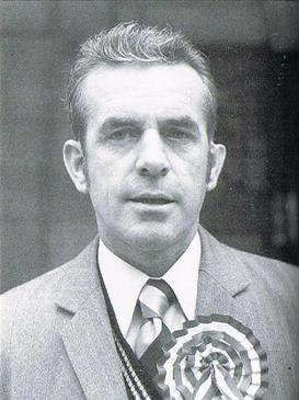
Kenneth Gibson was a Northern Irish politician who was the Chairman of the Volunteer Political Party (VPP), which he had helped to form in 1974. He also served as a spokesman and Chief of Staff of the loyalist paramilitary organisation, the Ulster Volunteer Force (UVF).
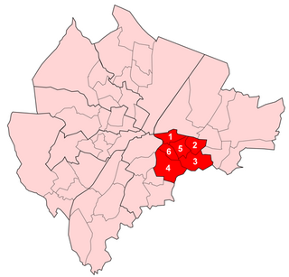
Pottinger was one of the nine district electoral areas (DEA) in Belfast, Northern Ireland from 1985 to 2014. Located in the east of the city, the district elected six members to Belfast City Council and contained the wards of Ballymacarrett, Bloomfield, Orangefield, Ravenhill, The Mount, and Woodstock.
William Elliot was a former Northern Irish loyalist who served as brigadier of the Ulster Defence Association's (UDA) East Belfast Brigade in the 1980s.
Braniel or The Braniel is a large housing estate and townland in southeast Belfast, Northern Ireland. It is in the barony of Castlereagh Upper and parish of Knockbreda in County Down. Two small developments, Roddens and Glenview, are located in the area, and are often referred to the Braniel. It is a predominantly unionist area.
The Shore Road is a major arterial route and area of housing and commerce that runs through north Belfast and Newtownabbey in Northern Ireland. It forms part of the A2 road, a traffic route which links Belfast to the County Antrim coast.
The Antrim Road is a major arterial route and area of housing and commerce that runs from inner city north Belfast to Dunadry, passing through Newtownabbey and Templepatrick. It forms part of the A6 road, a traffic route which links Belfast to Derry. It passes through the New Lodge, Newington and Glengormley areas of Northern Ireland amongst others.
Lisnasharragh is one of the ten district electoral areas (DEA) in Belfast, Northern Ireland. The district elects six members to Belfast City Council and contains the wards of Cregagh; Hillfoot; Merok; Orangefield; Ravenhill and Rosetta. Lisnasharragh forms part of the Belfast South and Belfast East constituencies for the Northern Ireland Assembly and UK Parliament.
Knockbreda is a civil parish in County Down, Northern Ireland. It is situated mainly in the historic barony of Castlereagh Upper, with 4 townlands in the barony of Castlereagh Lower.
Castlereagh Central was one of the district electoral areas in Castlereagh, Northern Ireland which existed from 1985 to 2014. It was one of three Castlereagh DEAs until 1993, and one of four until 2014. The district elected seven members to Castlereagh Borough Council from 1985 to 1993, and six members from 1993 to 2014. It formed part of the Strangford constituency until 1997, the Strangford and Belfast East constituencies from 1997 to 2010 and the Belfast East and Belfast South constituencies for the Northern Ireland Assembly and UK Parliament.
References
↑ Keith Haines, East Belfast: Paintings and Stories from Harbour to Hills, Dundurn Press Ltd., 2001, pp. 3–7
↑ Richard S. Grayson, Belfast Boys: How Unionists and Nationalists Fought and Died Together in the First World War, Continuum International Publishing Group, 2009, p. 151
↑ Gregory John Ashworth, Brian J. Graham, Senses of place: senses of time, Ashgate Publishing, 2005, p. 126
This page is based on this Wikipedia article Text is available under the CC BY-SA 4.0 license; additional terms may apply. Images, videos and audio are available under their respective licenses.