
Royal Hillsborough, more commonly known simply as Hillsborough, is a village and civil parish in County Down, Northern Ireland, 19 km (12 mi) from the city of Belfast. It is within the Lisburn and Castlereagh District Council area. The village is noted for its Georgian architecture. It is home to Hillsborough Castle, the British royal family's official residence in Northern Ireland, and residence of the British Secretary of State for Northern Ireland.

Banbridge was a local government district in Northern Ireland. The district was one of 26 council areas formed on 1 October 1973, following the implementation of the Local Government Act 1972. The headquarters of the council were in the town of Banbridge. In April 2015, most of the Banbridge district was included in the merged Armagh, Banbridge and Craigavon district. Some smaller areas in the east of the district became merged with the Newry, Mourne and Down District

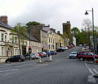
Dromore is a small market town and civil parish in County Down, Northern Ireland. It lies within the local government district of Armagh City, Banbridge and Craigavon. It is 19 miles (31 km) southwest of Belfast, on the A1 Belfast–Dublin road. The 2011 census recorded a population of 6,395.

Dundonald is a large settlement and civil parish in County Down, Northern Ireland, United Kingdom. It lies east of Belfast and is often considered a suburb of the city. It is home to the Ulster Hospital, Dundonald International Ice Bowl, Dundonald Omnipark, has a Park and Ride facility for the Glider, access to the Comber Greenway and several housing developments. John de Courcey established a keep including a motte-and-bailey in the 12th century. This is known as Moat Park and can be accessed from Church Green, Comber Road and the Upper Newtownards Road.

Kinallen is a small village and townland in County Down, Northern Ireland. It is four miles from Dromore and two miles from Dromara.

Rathfriland is a market town in County Down, Northern Ireland. It is 8 miles (13 km) north-east of Newry town centre.

Donaghcloney or Donacloney is a village, townland and civil parish in County Down, Northern Ireland. It lies on the River Lagan between Lurgan and Dromore. In the 2011 census it had a population of 1701. It is colloquially referred to as "The 'Cloney" by locals.

Laurencetown or Lawrencetown is a small village in County Down, Northern Ireland. It sits on the River Bann, along the main road between the towns of Banbridge and Portadown. It is within the parish of Tullylish and covers the townlands of Knocknagore and Drumnascamph. In the 2011 census it had a population of 956 people. In Irish, it is known as Baile Labhráis.
Richhill is a large village and townland in County Armagh, Northern Ireland. It lies between Armagh and Portadown. It had a population of 2,738 people in the 2021 Census.

Lenaderg is a small village and townland of 335 acres (136 ha) in County Down, Northern Ireland. It sits on the banks of the River Bann, about two miles from Banbridge and a half mile from the village of Lawrencetown. It is situated in the civil parish of Tullylish and the historic barony of Iveagh Lower, Upper Half. As of the 2001 census, it had a population of 261 people. Lenaderg is within the District of Banbridge.

Tullylish is a small village, townland and civil parish in County Down, Northern Ireland. It sits on the River Bann, along the main road between the towns of Banbridge and Portadown. In the 2001 census it had a population of 105 people. It lies within the civil parish of Tullylish and Banbridge District.
Waringsford is a small village in County Down, Northern Ireland, 6 km south east of Dromore. It is situated within Banbridge District. In the 2001 Census it had a population of 129 people. The village, despite the lack of services, has seen substantial property development in the last five years, helped by its rural setting, relative tranquility and close proximity to the A1.

Lisnadill is a hamlet, townland and civil parish in County Armagh, Northern Ireland. In the 2001 Census it had a population of 54 people. It lies about 3 miles south of Armagh and is within the Armagh City, Banbridge and Craigavon Borough Council area.
Mountnorris is a small village and townland in County Armagh, Northern Ireland. The village also extends into the townland of Tullyherron. It lies about six miles south of Markethill. It is within the Armagh, Banbridge and Craigavon local government area. It had a population of 155 people in the 2011 Census. Ulsterbus offers 1 stop in mountnorris. (2001 Census: 165 people
Corbet is a small village and townland in County Down, Northern Ireland, 5 km east of Banbridge. It is situated in the civil parish of Magherally and the historic barony of Iveagh Lower, Lower Half. It lies within the Banbridge District. It had a population of 107 people in the 2011 Census.
Leitrim, is a small village in County Down, Northern Ireland, approximately 3 miles from Castlewellan, near Dromara, in the parish of Drumgooland. It is set between the Dromara Hills and the Mourne Mountains. It is claimed to be home to the MacCartan clan of Kinelarty.
Broomhedge is a small village in County Antrim, Northern Ireland, near Lisburn, approximately 12 miles (19 km) southwest of Belfast. It lies within the Lisburn and Castlereagh City Council area, and the Maghaberry electoral ward.

Banbridge is a town in County Down, Northern Ireland. It lies on the River Bann and the A1 road and is named after a bridge built over the River Bann in 1712. It is situated in the civil parish of Seapatrick and the historic barony of Iveagh Upper, Upper Half. The town began as a coaching stop on the road from Belfast to Dublin and thrived from Irish linen manufacturing. The town was home to the headquarters of the former Banbridge District Council. Following a reform of local government in Northern Ireland in 2015, Banbridge became part of Armagh City, Banbridge and Craigavon Borough Council. It had a population of 17,400 in the 2021 census.

Katesbridge railway station was a railway station serving the small hamlet of Katesbridge in County Down, Northern Ireland. It was located on the Great Northern Railway (Ireland) which ran from Banbridge to Castlewellan.


