
Gilford is a village in County Down, Northern Ireland. The village sits on the River Bann between the towns of Banbridge, Tandragee and Portadown. It covers the townlands of Loughans, Ballymacanallen and Drumaran. It had a population of 1,933 people in the 2011 census. Gilford is within the Armagh, Banbridge and Craigavon district.

Rathfriland is a market town in County Down, Northern Ireland. It is 8 miles (13 km) north-east of Newry town centre.

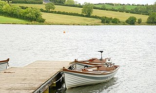
Laurencetown or Lawrencetown is a small village in County Down, Northern Ireland. It sits on the River Bann, along the main road between the towns of Banbridge and Portadown. It is within the parish of Tullylish and covers the townlands of Knocknagore and Drumnascamph. In the 2011 census it had a population of 956 people. In Irish, it is known as Baile Labhráis.

Lenaderg is a small village and townland of 335 acres (136 ha) in County Down, Northern Ireland. It sits on the banks of the River Bann, about two miles from Banbridge and a half mile from the village of Lawrencetown. It is situated in the civil parish of Tullylish and the historic barony of Iveagh Lower, Upper Half. As of the 2001 census, it had a population of 261 people. Lenaderg is within the District of Banbridge.
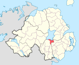
Corbet is a small village and townland in County Down, Northern Ireland, 5 km east of Banbridge. It is situated in the civil parish of Magherally and the historic barony of Iveagh Lower, Lower Half. It lies within the Banbridge District. It had a population of 107 people in the 2011 Census.

Banbridge is a town in County Down, Northern Ireland. It lies on the River Bann and the A1 road and is named after a bridge built over the River Bann in 1712. It is situated in the civil parish of Seapatrick and the historic barony of Iveagh Upper, Upper Half. The town began as a coaching stop on the road from Belfast to Dublin and thrived from Irish linen manufacturing. The town was home to the headquarters of the former Banbridge District Council. Following a reform of local government in Northern Ireland in 2015, Banbridge became part of Armagh City, Banbridge and Craigavon Borough Council. It had a population of 17,400 in the 2021 census.
Annaclone is a village and civil parish between Rathfriland and Banbridge in south County Down, Northern Ireland, about 7 km south-east of Banbridge. The village is situated in the townlands of Ardbrin and Tullintanvally and both it and the civil parish are located in the historic barony of Iveagh Upper, Upper Half. It had a population of 150 people in the 2011 Census.

Oneilland West is a barony in County Armagh, Northern Ireland. It is also called Clancann, after the Mac Cana clan. It lies in the north of the county on the south-western shore of Lough Neagh and the border of County Tyrone. Oneilland West is bordered by five other baronies: Armagh to the west; Dungannon Middle to the north-west; Oneilland East to the north-east; Orior Lower to the south-east; and Kinelarty to the south.
Oneilland East is a barony in the north-east of County Armagh, Northern Ireland. It is also called Clanbrasil. It lies in the north-east corner of the county, on the south-eastern shore of Lough Neagh and the boundary with County Down. Oneilland East is bordered by three other baronies: Oneilland West to the west; Iveagh Lower to the east; and Orior Lower to the south.
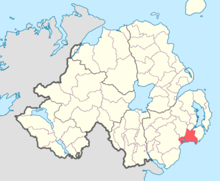
Lecale Upper is a barony in County Down, Northern Ireland. To its south lies the Irish Sea, and it is bordered by three other baronies; Lecale Lower and Kinelarty to the north; and Iveagh Upper, Lower Half to the west.

Kinelarty is a former Irish district and barony in County Down, Northern Ireland. It lies east of the centre of the county, and is bordered by five other baronies: Iveagh Upper, Lower Half to the west; Lecale Upper to the south and south-east; Lecale Lower to the east; Castlereagh Upper to the north; and Iveagh Lower, Upper Half to the north-west.

Iveagh Upper, Lower Half is the name of a barony in County Down, Northern Ireland. It was created by 1851 with the division of the barony of Iveagh Upper into two. It lies in the centre of the county, and is bordered by six other baronies: Iveagh Upper, Upper Half and Lordship of Newry to the west; Mourne to the south; Kinelarty and Lecale Upper to the east; and Iveagh Lower, Upper Half to the north.

Iveagh Upper, Upper Half is the name of a barony in County Down, Northern Ireland. It was created by 1851 with the division of the barony of Iveagh Upper into two. It lies to the west and south of the county, split in half by the Lordship of Newry. It is bordered by six other baronies: Mourne to the south; Iveagh Upper, Lower Half to the east; Iveagh Lower, Lower Half and Iveagh Lower, Upper Half to the north; and Orior Lower and Orior Upper to the west.

Iveagh Lower, Upper Half is the name of a barony in County Down, Northern Ireland. It was created by 1851 with the division of the barony of Iveagh Lower into two. It is bordered by five other baronies: Iveagh Upper, Lower Half to the south; Iveagh Upper, Upper Half to the south-west; Iveagh Lower, Lower Half to the west and north; Castlereagh Upper to the north-east; and Kinelarty to the west.

Iveagh Lower, Lower Half is the name of a barony in County Down, Northern Ireland. It was created by 1851 with the division of the barony of Iveagh Lower into two. It is bordered by six other baronies: Massereene Upper to the north; Castlereagh Upper to the east; Iveagh Lower, Upper Half and Iveagh Upper, Upper Half to the south; Oneilland East and Orior Lower to the west.
Seapatrick is a civil parish in County Down, Northern Ireland. It lies partly across the three historic baronies of Iveagh Upper, Upper Half, Iveagh Lower, Lower Half and Iveagh Lower, Upper Half.
Ballynanny (Annaclone) (from Irish Bealach an Eanaigh, meaning 'routeway of the marsh') is a townland of 538 acres in County Down, Northern Ireland. It is situated in the civil parish of Annaclone and the historic barony of Iveagh Upper, Upper Half.

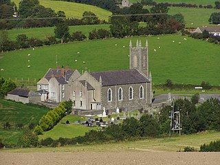
Magherally is a civil parish and townland in County Down, Northern Ireland. It is largely situated in the historic barony of Iveagh Lower, Lower Half, with one townland (Tullyhinan) in the barony of Iveagh Lower, Upper Half. The townland of Magherally contains the parish church.
Annaghanoon is a rural townland in County Down, Northern Ireland. It has an area of 626.03 acres (2.53 km2). It is situated in the civil parish of Donaghcloney and the historic barony of Iveagh Lower, Upper Half, located 1 mile west of Donaghcloney. It lies within the Armagh City, Banbridge and Craigavon Borough Council.


