Related Research Articles

Newtownards is a town in County Down, Northern Ireland. It lies at the most northern tip of Strangford Lough, 10 miles (16 km) east of Belfast, on the Ards Peninsula. It is in the civil parish of Newtownards and the historic baronies of Ards Lower and Castlereagh Lower. Newtownards is in the Ards and North Down Borough. The population was 29,677 in the 2021 Census.
The vast majority of placenamesin Ireland are anglicisations of Irish language names; that is, adaptations of the Irish names to English phonology and spelling. However, some names come directly from the English language, and a handful come from Old Norse and Scots. The study of placenames in Ireland unveils features of the country's history and geography and the development of the Irish language. The name of Ireland itself comes from the Irish name Éire, added to the Germanic word land. In mythology, Éire was an Irish goddess of the land and of sovereignty.

Larne is a town on the east coast of County Antrim, Northern Ireland, with a population of 18,853 at the 2021 census. It is a major passenger and freight roll-on roll-off port. Larne is administered by Mid and East Antrim Borough Council. Together with parts of the neighbouring districts of Antrim and Newtownabbey and Causeway Coast and Glens, it forms the East Antrim constituency for elections to the Westminster Parliament and Northern Ireland Assembly. The civil parish is in the historic barony of Glenarm Upper.
Donaghadee is a small town in County Down, Northern Ireland. It lies on the northeast coast of the Ards Peninsula, about 18 miles (29 km) east of Belfast and about six miles (10 km) south east of Bangor. It is in the civil parish of Donaghadee and the historic barony of Ards Lower. It had a population of 6,869 people in the 2011 Census.
Carryduff is a small town and townland in County Down, Northern Ireland, about 10 kilometres (6.2 mi) south of Belfast city centre. It had a population of 7,173 people in the 2021 Census. Most of the settlement lies within the townland of Carryduff, although part of it extends into the neighbouring townlands of Killynure and Mealough.
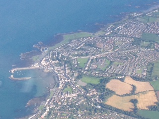
The Ards Peninsula is a peninsula in County Down, Northern Ireland, on the north-east coast of Ireland. It separates Strangford Lough from the North Channel of the Irish Sea. Towns and villages on the peninsula include Donaghadee, Millisle, Portavogie and Portaferry. The large towns of Newtownards and Bangor are at the mainland edge of the peninsula. Burr Point is the easternmost point on the island of Ireland.

Dromore is a small market town and civil parish in County Down, Northern Ireland. It lies within the local government district of Armagh City, Banbridge and Craigavon. It is 19 miles (31 km) southwest of Belfast, on the A1 Belfast–Dublin road. The 2011 Census recorded a population of 6,395.

Millisle or Mill Isle is a village on the Ards Peninsula in County Down, Northern Ireland. It is about 3 miles (4.8 km) south of Donaghadee. It is situated in the townlands of Ballymacruise and Ballycopeland, the civil parish of Donaghadee and the historic barony of Ards Lower. It had a population of 2,318 people in the 2011 Census.

The R236 road runs in County Donegal in Ulster, and links Stranorlar, via Convoy and Raphoe, to St Johnston and Carrigans, becoming the A40 into Derry in Northern Ireland.

Groomsport is a suburb of Bangor in County Down, Northern Ireland. It is on the south shore of Belfast Lough and on the north coast of the Ards Peninsula. Groomsport has a population of 3,005 people according to the 2011 Census. It is part of the Ards and North Down Borough.

Ardagh is a townland in the fertile district known as the Laggan in East Donegal, part of County Donegal, Ireland. It is very near St Johnston. It became part of the large Abercorn Estate and was settled by mainly Lowland Scots settlers during the Plantation of Ulster.

Ballywalter is a village or townland and civil parish in County Down, Northern Ireland. It is on the east coast of the Ards Peninsula between Donaghadee and Ballyhalbert. Ballywalter was formerly known as Whitkirk as far back as the 12th century. It had a population of 2,027 people in the 2011 census.
Greyabbey or Grey Abbey is a small village, townland and civil parish located on the eastern shores of Strangford Lough, on the Ards Peninsula in County Down, Northern Ireland.

St Johnston, officially Saint Johnstown, is a village, townland, and an electoral division in County Donegal, Ireland. It is in the Laggan district of East Donegal on the left bank of the River Foyle. It is in the civil parish of Taughboyne and barony of Raphoe North, on the R236 (Lifford–Newtowncunningham) road where it overlaps the R265 (Carrigans–Raphoe) road. The village is about 12 kilometres (7.5 mi) south of Derry.
Joseph Johnston was an Irish academic, farmer, writer and politician.
Bangor is a civil and ecclesiastical parish in County Down, Northern Ireland. It is located in the north of the Ards Peninsula, consisting of 30 townlands, twenty-two and a half of which lie in the barony of Ards Lower, with seven and a half lying within that of Castlereagh Lower. Its ancient monastery was of ecclesiastical importance.
In the history of land use in Ireland, a townpark or town park was a smallholding near a town and farmed by someone resident in the town. Typically, a major landowner provided a contiguous area near the town which was subdivided into multiple townparks, each rented on a short-term lease, for a higher rent than that paid by a full-time resident farmer.

The Finn River, also known as the River Finn, is a small river that flows through parts of County Fermanagh and parts of County Monaghan in the south of Ulster, the northern province in Ireland. In certain places, the river forms part of the boundary between County Fermanagh, which is part of Northern Ireland, and County Monaghan, which is part of the Republic of Ireland. Two very short stretches of the river, just north of Redhills and at Castle Saunderson, near Belturbet, also form part of the boundary between County Fermanagh and County Cavan. This means that some stretches of the river form part of the border between Northern Ireland and the Republic of Ireland, these short stretches also forming part of the external border of the European Union.
References
- 1 2 "Ballyhay". Place Names NI. Retrieved 21 February 2013.
- ↑ M'Gimpsey Johnston, John. "Another Ulster-Scots Writer: John M'Gimpsey Johnston". Ullans: The Magazine for Ulster-Scots. Ulster-Scots Academy.
