
Ballyroan is a suburb in Rathfarnham, County Dublin in Ireland. It lies at the foot of the Dublin mountains, alongside Ballyboden, Butterfield, Knocklyon, Old Orchard, and Scholarstown. The townland of Ballyroan crosses civil parish and barony boundaries with roughly 114 acres of the historical townland in the civil parish of Tallaght in the barony of Uppercross, and nearly 10 acres in the civil parish of Rathfarnham in the barony of Rathdown. The modern suburb of Ballyroan has extended somewhat beyond the traditional townland boundaries.
Ballywalter is a village, townland and civil parish in County Down, Northern Ireland. It is on the east coast of the Ards Peninsula between Donaghadee and Ballyhalbert. Ballywalter was formerly known as Whitkirk as far back as the 12th century. It had a population of 2,027 people in the 2011 census.

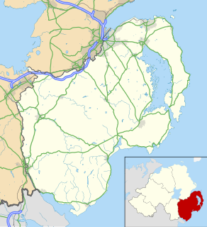
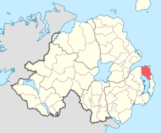
Carrowdore is a small village on the Ards Peninsula in County Down, Northern Ireland. It is situated in the townland of Ballyrawer, the civil parish of Donaghadee and the historic barony of Ards Lower. It lies within the Ards and North Down Borough. It had a population of 960 people in the 2011 Census.

Drumbeg is a small village, townland and civil parish on the south bank of the River Lagan in County Down, Northern Ireland. The village is covered by the Lisburn City Council area and forms part of the suburban fringe of Belfast.

Lambeg is a small village and civil parish in County Antrim, Northern Ireland. Located between Belfast and Lisburn, it was once a small rural village, but is now within the Greater Belfast conurbation. Lambeg is also an electoral ward of Lisburn Council. In the 2001 Census it had a population of 60 people. The civil parish of Lambeg covers areas of County Down as well as County Antrim.

Tullylish is a small village, townland and civil parish in County Down, Northern Ireland. It sits on the River Bann, along the main road between the towns of Banbridge and Portadown. In the 2001 Census it had a population of 105 people. It lies within the civil parish of Tullylish and Banbridge District.

Benraw is a townland of 860 acres in County Down, Northern Ireland, two miles north of Leitrim, County Down and six miles from Castlewellan. It is situated in the civil parish of Drumgooland and the historic barony of Iveagh Upper, Lower Half. It is set in the middle of the Dromara Hills and Slieve Croob. It has an average population of 50 people. It contains two roads: the Whitehill Road and the Benraw Road. It is in the middle of the townlands Leitrim, Legananny and Derryneill. It is a very mountainous area and the two main mountains in Benraw are Benraw Mountain and The Whitehill. Benraw is also close to Legananny Dolmen.
Doon is the name of three townlands in County Cavan, Ireland, with one situated in the civil parishes of Drumreilly, Mullagh, and Tomregan. All three derive their name from the Irish term Dún, meaning "fort".
Ards Lower, alternatively known as North Ards, is a barony in County Down, Northern Ireland. It lies on the northern half of the Ards Peninsula in the north-east of the county, with the Irish Sea to its east and Strangford Lough to its south-west. It is bordered by two other baronies: Ards Upper to the south; and Castlereagh Lower to the west.
Bangor is a civil and ecclesiastical parish in County Down, Northern Ireland. It is located in the north of the Ards Peninsula, consisting of 30 townlands, twenty-two and a half of which lie in the barony of Ards Lower, with seven and a half lying within that of Castlereagh Lower. Its ancient monastery was of ecclesiastical importance.
Killinchy is a civil parish in County Down, Northern Ireland. It is mainly situated in the historic barony of Dufferin, with two smaller portions in the baronies of Castlereagh Upper and Castlereagh Lower.
Comber is a civil parish in County Down, Northern Ireland. It is mainly situated in the historic barony of Castlereagh Lower, with a small portion in the barony of Castlereagh Upper.

Tullynakill is a civil parish and townland in County Down, Northern Ireland. It is situated in the historic barony of Castlereagh Lower.

Corraclassy is a townland in the civil parish of Templeport, County Cavan, Ireland. It lies in the Roman Catholic parish of Corlough and barony of Tullyhaw.

Eaglehill is a townland in the civil parish of Templeport, County Cavan, Ireland. It lies in the Roman Catholic parish of Corlough and barony of Tullyhaw. The local pronunciation of the Gaelic name is Tullylugskiveranerla.
Tullytrasna is a townland in the civil parish of Templeport, County Cavan, Ireland. It lies in the Roman Catholic parish of Corlough and barony of Tullyhaw.

Tullynamoltra is a townland in the civil parish of Templeport, County Cavan, Ireland. It lies in the Roman Catholic parish of Corlough and barony of Tullyhaw. The local pronunciation is Tullynamoiltra.
Tullandreen is a townland in the civil parish of Templeport, County Cavan, Ireland. It lies in the Roman Catholic parish of Corlough and barony of Tullyhaw. The local pronunciation is Tulleanderreen.


