
Devenish or Devinish is an island in Lower Lough Erne, County Fermanagh, Northern Ireland. Aligned roughly north–south, it is about one and a quarter miles long and two-thirds of a mile wide. The main place to catch a ferry to the island is at Trory Point, just outside Enniskillen. Devenish Island is owned by the Kilravock Christian Trust.
Loughinisland is a small village and civil parish in County Down, Northern Ireland. It is between Downpatrick and Ballynahinch, about 21 miles south of Belfast.

Ballynoe is a small settlement and townland south of Downpatrick in County Down, Northern Ireland. It is situated in the civil parish of Bright and historic barony of Lecale Upper.

Donaghmore is a village, townland and civil parish in County Tyrone, Northern Ireland, about five kilometres (3 mi) northwest of Dungannon. In the 2011 Census it had a population of 1,122 people. The village is beside the River Torrent, formerly known as the Torrent Flow.
Dromara is a small village, townland and civil parish in County Down, Northern Ireland. It lies 10 kilometres (6.2 mi) to the southwest of Ballynahinch on the northern slopes of Slieve Croob, with the River Lagan flowing through it. It is situated in Dromara and the historic barony of Iveagh Lower, Lower Half. In the 2001 Census it had a population of 597 people.

Cowd Castle is a castle situated in Ardglass, County Down, Northern Ireland. It is on the other side of the road from Margaret's Castle, at the entrance to Ardglass Golf Club. It is a small two-storey tower which may date from the late 15th century or early 16th century. The doorway is in the west wall. A straight mural stairway led to the upper level.

Sketrick Castle is a castle situated on Sketrick Island near Whiterock, County Down, Northern Ireland. The castle is estimated to date back to the 12th century. Sketrick Castle tower-house and the passage to spring are State Care Historic Monuments in the townland of Sketrick Island, in the Ards and North Down Borough, at grid ref: J5245 6252.

White Island is an island in Lower Lough Erne, County Fermanagh, Northern Ireland. It is situated in Castle Archdale Bay off the east shore of Lower Lough Erne. The ruins of an ancient church are found near the shore, built on the site of an earlier monastic settlement. It still has an intact arched Romanesque doorway. The Church and carved figures are State Care Historic Monuments sited in the townland of White Island, in Fermanagh and Omagh District Council area, at grid ref: H1753 6000. The rath, earthwork, and area surrounding the state care monument are Scheduled Historic Monuments, at grid ref: H1753 6000. The island is accessed by ferry from the marina in Castle Archdale Country Park, near Irvinestown. Location: Open Street Map Reference

Carnteel ) is a hamlet, townland and civil parish, about 2 miles northeast of Aughnacloy in County Tyrone, Northern Ireland. It is situated in the historic barony of Dungannon Lower.

Grey Abbey is a ruined Cistercian priory in the village of Greyabbey, County Down, Northern Ireland, currently maintained by the Northern Ireland Environment Agency. It is a monument in state care in the townland of Rosemount, beside the Rosemount estate, on the eastern edge of the village of Greyabbey in the Ards and North Down local government district, at grid ref: J5829 6810.
Ballynahatty is a townland in County Down, Northern Ireland. It lies on the southern edge of Belfast. It contains the Giants Ring, a henge monument, consisting of a circular enclosure, 200m in diameter, surrounded with a 4m high earthwork bank with five entrances, and a small neolithic passage grave slightly off-centre. The Giant's Ring is a State Care Historic Monument at grid ref: J3272 6770.
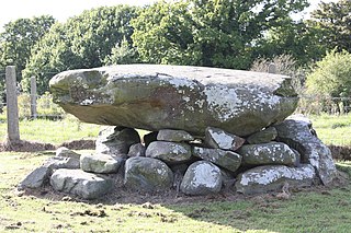
Annadorn Dolmen is a dolmen sited at the Buck's Head near Loughinisland, in the townland of Annadorn. Nearby you can find the old Annadorn school and post office in County Down, Northern Ireland. It is on the north-east shore of Loughinisland Lake, on a hillock overlooking Loughinisland Churches, a group of three ruined churches. The site is a State Care Historic Monument at grid ref: J4289 4591. Co-ordinates: Latitude: 54° 20' 29.97" N Longitude: 5° 48' 8.72" W

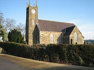
The Loughinisland Churches are the remains of three ruined churches in Loughinisland, County Down, Northern Ireland, dating from the 13th to the 17th centuries. They are situated in Tievenadarragh townland, in a large graveyard on an island in Loughinisland Lake, now reached by a causeway. The churches are state-care historic monuments at grid ref: J4234 4537.
Solar is a townland of 42 acres in County Antrim, Northern Ireland. It is situated in the civil parish of Carncastle and the historic barony of Glenarm Upper.
Ballydown is a townland of 529 acres in County Down, Northern Ireland. It is situated in the civil parish of Seapatrick and the historic barony of Iveagh Upper, Lower Half.

Tullynakill is a civil parish and townland in County Down, Northern Ireland. It is situated in the historic barony of Castlereagh Lower.

Kinelarty is a former Irish district and barony in County Down, Northern Ireland. It lies east of the centre of the county, and is bordered by five other baronies: Iveagh Upper, Lower Half to the west; Lecale Upper to the south and south-east; Lecale Lower to the east; Castlereagh Upper to the north; and Iveagh Lower, Upper Half to the north-west.

Ardtole is a townland of 431 acres in County Down, Northern Ireland, near Ardglass. It is situated in the civil parish of Ardglass and the historic barony of Lecale Lower. The southern part of Ardtole townland is known as English Ardtole and the northern part is known as Irish Ardtole.

Killaney is a civil parish in County Down, Northern Ireland. It is situated in the historic barony of Castlereagh Upper. It is also a townland of 298 acres. Killaney lies east of Lough Henney, next to an area of bog to the south-west of Saintfield.
Legacurry is a townland of 100 acres in County Down, Northern Ireland. It is situated in the civil parish of Drumbo and the historic barony of Castlereagh Upper.


