Related Research Articles

In the United Kingdom, a scheduled monument is a nationally important archaeological site or historic building, given protection against unauthorised change.

County Down is one of the six counties of Northern Ireland, one of the nine counties of Ulster and one of the traditional thirty-two counties of Ireland. It covers an area of 961 sq mi (2,490 km2) and has a population of 531,665. It borders County Antrim to the north, the Irish Sea to the east, County Armagh to the west, and County Louth across Carlingford Lough to the southwest.

A listed building, or listed structure, is one that has been placed on one of the four statutory lists maintained by Historic England in England, Historic Environment Scotland in Scotland, Cadw in Wales and the Northern Ireland Environment Agency in Northern Ireland.
Ards was a local government district in Northern Ireland with the status of borough. It was one of twenty-six districts formed on 1 October 1973, and had its headquarters in Newtownards. It was merged with neighbouring North Down on 1 May 2015 to form the new Borough of Ards and North Down. Other towns in the defunct Borough included Portaferry, Comber, and Donaghadee, and the population of the area was 78,078 according to the 2011 census.
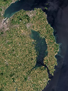
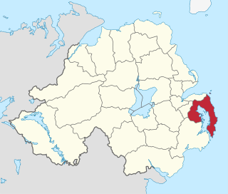
The Ards Peninsula is a peninsula in County Down, Northern Ireland, on the north-east coast of Ireland. It separates Strangford Lough from the North Channel of the Irish Sea. Towns and villages on the peninsula include Donaghadee, Millisle, Portavogie and Portaferry. The large towns of Newtownards and Bangor are at the mainland edge of the peninsula. Burr Point is the easternmost point on the island of Ireland.

Lochbuie is a settlement on the Isle of Mull in Scotland about 22 kilometres (14 mi) west of Craignure.

Cabrillo National Monument is at the southern tip of the Point Loma Peninsula in San Diego, California, United States. It commemorates the landing of Juan Rodríguez Cabrillo at San Diego Bay on September 28, 1542. This event marked the first time a European expedition had set foot on what later became the West Coast of the United States. The site was designated as California Historical Landmark #56 in 1932. As with all historical units of the National Park Service, Cabrillo was listed on the National Register of Historic Places on October 15, 1966.
Skipness Castle stands on the east side of the Kintyre peninsula in Scotland, near the village of Skipness. Together with the nearby Kilbrannan Chapel it is a scheduled ancient monument.

The Clach a' Charridh or Shandwick Stone is a Class II Pictish stone located near Shandwick on the Tarbat peninsula in Easter Ross, Scotland. It is a scheduled monument.

Grey Abbey is a ruined Cistercian priory in the village of Greyabbey, County Down, Northern Ireland, currently maintained by the Northern Ireland Environment Agency. It is a monument in state care in the townland of Rosemount, beside the Rosemount estate, on the eastern edge of the village of Greyabbey in the Ards and North Down local government district, at grid ref: J5829 6810.

There are 37 scheduled monuments in Greater Manchester, a metropolitan county in North West England. In the United Kingdom, a scheduled monument is a "nationally important" archaeological site or historic building that has been given protection against unauthorised change by being placed on a list by the Secretary of State for Digital Culture, Media and Sport; Historic England recommends sites for scheduling to the Secretary of State. Scheduled monuments are defined in the Ancient Monuments and Archaeological Areas Act 1979 and the National Heritage Act 1983. There are nearly 20,000 entries on the schedule, which is maintained by Historic England as part of the National Heritage List for England; more than one site can be included in a single entry. While a scheduled monument can also be recognised as a listed building, Historic England's aim is to set the most appropriate form of protection in place for the building or site. Applications to deschedule a site are administered Historic England, who will carry out an assessment and make a recommendation to the Secretary of State.

ARD alpha is a German free-to-air television channel run by regional public-service broadcaster Bayerischer Rundfunk. Its programming consists of shows made by Bayerischer Rundfunk, as well as from ARD and Austrian broadcaster ORF. The channel was originally called BR-alpha but was rebranded as ARD-alpha on 29 June 2014.
An annual Heritage at Risk Register is published by Historic England. The survey is used by national and local government, a wide range of individuals and heritage groups to establish the extent of risk and to help assess priorities for action and funding decisions. This heritage-at-risk data is one of the UK government's official statistics.
The White House is a ruined 17th century dwelling house at Ballyspurge, near Cloghy, County Down, Northern Ireland on the Ards Peninsula. It is situated about one mile (1.2 km) south-east of Cloghy, overlooking Slanes Bay. It is a State Care Historic Monument at grid ref: J6248 5506.

Ards and North Down is a local government district in Northern Ireland. It was created on 1 April 2015 by merging the Borough of Ards and the Borough of North Down. The local authority is Ards and North Down Borough Council.

Rubha an Dùnain or Rubh' an Dùnain is an uninhabited peninsula to the south of the Cuillin hills on the Isle of Skye in Scotland. It contains unique archaeological sites which in 2017 were designated as a Historic Monument of national importance by Historic Environment Scotland.

Bath and North East Somerset is a unitary authority created on 1 April 1996, following the abolition of the County of Avon, which had existed since 1974. Part of the ceremonial county of Somerset, Bath and North East Somerset occupies an area of 220 square miles (570 km2), two-thirds of which is green belt. It stretches from the outskirts of Bristol, south into the Mendip Hills and east to the southern Cotswold Hills and Wiltshire border. The city of Bath is the principal settlement in the district, but BANES also covers Keynsham, Midsomer Norton, Radstock and the Chew Valley. The area has a population of 170,000, about half of whom live in Bath, making it 12 times more densely populated than the rest of the area.

There are over 670 scheduled monuments in the ceremonial county of Somerset in South West England. The county consists of a non-metropolitan county, administered by Somerset County Council, which is divided into five districts, and two unitary authorities. The districts of Somerset are West Somerset, South Somerset, Taunton Deane, Mendip and Sedgemoor. The two administratively independent unitary authorities, which were established on 1 April 1996 following the breakup of the county of Avon, are North Somerset and Bath and North East Somerset. These unitary authorities include areas that were once part of Somerset before the creation of Avon in 1974.
Elections to Ards Borough Council were held on 5 May 2011 on the same day as the other Northern Irish local government elections. The election used four district electoral areas to elect a total of 23 councillors.
References
- ↑ "Ards Peninsula". The Stone Circle. Retrieved 14 July 2009.
- ↑ "Ballyfounder" (PDF). Scheduled Historic Monuments. Archived from the original (PDF) on 19 April 2009. Retrieved 14 July 2009.