Lecale

Last updated • 5 min readFrom Wikipedia, The Free Encyclopedia

Lecale
Leath Cathail(Irish)
Lecale.png
Location of the former barony of Lecale, County Down, in present-day Northern Ireland. It was based on the Irish district of Leath Cathail
Sovereign state United Kingdom
Country Northern Ireland
County Down

Lecale (leh-KAHL, from Irish Leath Cathail 'Cathal's half') [1] is a peninsula in the east of County Down, Northern Ireland. It lies between Strangford Lough and Dundrum Bay. In the Middle Ages it was a district or túath in the Gaelic Irish kingdom of Ulaid, then became a county in the Anglo-Norman Earldom of Ulster. Later it became a barony, which was split into Lecale Lower and Lecale Upper by 1851. [2] Its largest settlement is the town of Downpatrick. Other settlements include Ardglass, Killough and Strangford. The peninsula has a high concentration of tower houses. Much of it is part of the 'Strangford and Lecale' Area of Outstanding Natural Beauty.

Contents

History

Historic map of Lecale by Alice Stopford Green (1912). Historic map of Lecale - Alice Stopford Green, 1912.jpg
Historic map of Lecale by Alice Stopford Green (1912).
Baronies of Down.jpg
Map of Lecale within the surrounding baronies of County Down (1900).

Leath Cathail

Leath Cathail is said to consist of the present-day baronies of Lecale Lower and Lecale Upper, [4] and was a subdivision of the ancient kingdom of Ulaid. It gets its name from Cathal, a prince of Ulaid about 700 A.D. who was a descendant of Fiachna, a son of Deaman, a king of Ulaid. [4] [5] [6] Hence, Leath Cathail literally means "Cathal's half of Dál Fiatach". [4]

More anciently Leath Cathail was known as Magh Inis, meaning the "island plain", with the name "Isle Lecale" still used in the area. [4] [5] These names reflect that until the first sea barriers and drainage systems were constructed about 200 years ago, that Lecale was almost entirely encircled by Dundrum Bay, Strangford Lough, and the Irish Sea. [5]

The Cenél nÓengusa are noted as being kings of Leath Cathail, with the Ua Flathraoi cited as lords by the 12th century. [4] According to the Annals of the Four Masters , on the day of the Festival of Paul and Peter (29 June) in 1147, the Ulaid gave battle to the Cenél nEógain of Tír Eoghain who had pursued them to the shores of Dún Droma (Dundrum Bay), Leath Cathail. The Ulaid suffered a heavy defeat, including the death of Árchú Ua Flathraoi, "lord of Leath-Chathail", with the victorious Cenél nEógain plundering Lecale and taking off with Ulidian hostages. [7]

Dundrum

This Dún Droma ("fort of the ridge"), is now known as Dundrum, [8] and is called Dún Droma Dairinne , the "fort of Dairinne's ridge", in a poem by Gilbride MacNamee, a bard of the Cenél nEóġain. [7] This poem, written to lament the death of Bryan O'Neill, and the defeat of the Irish at the battle of Downpatrick in 1260, boasts of their victories over their enemies and makes mentions the victory over the Ulidians, however in reference to the battle of Downpatrick, the bard would lament "Alas! We have paid for it". [7]

Dundrum Castle, which now occupies the original dún or earthen fort, is said to have been built for the Knights Templar by John de Courcy, and they are said to have held it until 1313 when their order was suppressed. It was afterward granted to the prior of Down. [7]

Saints Patrick, Brigid and Colmcille

Saint Patrick landed at the Slaney estuary on his return to Ireland. A large granite statue of him looking into the rest of Ireland at Raholp today overlooks the site. He died at the Abbey of Saul where he began his mission and was administered his dying communion by Bishop Tassach of Raholp. His remains were carried to Downpatrick, then known as Dun Dhá Leath Glais, which lies within Lecale Upper.

Brigid of Kildare's relics were brought to Downpatrick for safekeeping from Danish plunderers in 835 and Saint Columba was brought here from Iona in 877. [9] The frequent burning of Downpatrick caused them to be buried in the abbey yard and the site was forgotten about until 1185. [10] Upon rediscovery John de Courcy had them reinstated in a tomb within the abbey on 9 June 1186 by Cardinal Vivian.

The abbey was desecrated by the Lord Deputy of Ireland, Leonard Grey in 1538. [ why? ] He was executed three years later for his callous actions.[ citation needed ] It appears that the relics of the saints remained intact until 1790 when the building was being remodelled as Down Cathedral. Accounts have given record that the tomb was vandalised and the relics were scattered over the abbey yard prompting the Downpatrick people to hurriedly bury them at their present site. The town cross was reportedly placed on the grave but it was carried off and vandalised. The Belfast Naturalists' Field Club erected the large granite slab over the grave in 1900 to protect the grave as it had become customary for those leaving Ireland to take soil from the grave with them. [11]

Medieval and modern Lecale

The Earls of Kildare formerly held control of the customs of Strangford and Ardglass, both in Lecale Lower, of which it is noted that: [8]

"The port offered excellent sea communications and the fertile area of Lecale was prosperous, so de Courcey incorporated the whole as part of the Pale and rewarded his followers with grants of land. Later, Henry VIII granted the revenue of the port, amounting to £5,000, to Gerald Fitzgerald, Earl of Kildare. The association of the Kildare family with Ardglass continued for three centuries"

Lecale is also recorded under the name of "Ladcathel" as one of the five counties of the Earldom of Ulster in 1226, the other four being Antrim, Carrickfergus, 'del Art' (Ards) and 'Blathewyc' (Newtownards). By 1333, Antrim and Carrickfergus were still counties, Twescard had been added, 'del Art' seems to have become a part of Blathewyc and Lecale had been replaced by Down. [12] It was also the name of a former barony in Ireland, which by 1851 had been split into Lecale Lower and Lecale Upper. [2]

The Russells of Downpatrick have been established in Lecale since the 12th century having been recorded in the area since Osberto Russell accompanied John de Courcy in 1177 into Ulster. [13] Thomas Russell, one of the leaders of the United Irishmen who led the rising of 1803, was imprisoned in Downpatrick gaol and on 21 October 1803 was hanged at the gate of the gaol. "The Man From God Knows Where" is a ballad written by Florence Wilson in commemoration of him. [8]

Geography

Until 1745, when the first sea barriers were constructed by Edward Southwell, the sea encircled almost the whole of the area. This action saw the creation of the River Quoile and 500 acres (200 ha) of land around Downpatrick. Strangford Lough bounds the northern edge and the Irish Sea the east and Dundrum inner bay forms the western edge, with St. John's point forming its southern tip.

In 1967, a 3,108 ha (7,680 acres) area of the Lecale Peninsula, lying between the Mourne Mountains and Strangford Lough, was designated as the Lecale Coast Area of Outstanding Natural Beauty. [14]

See also

Related Research Articles

<span class="mw-page-title-main">Downpatrick</span> Town in Northern Ireland

Downpatrick is a town in County Down, Northern Ireland. It is on the Lecale peninsula, about 21 mi (34 km) south of Belfast. In the Middle Ages, it was the capital of the Dál Fiatach, the main ruling dynasty of Ulaid. Its cathedral is said to be the burial place of Saint Patrick. Today, it is the county town of Down and the joint headquarters of Newry, Mourne and Down District Council. Downpatrick had a population of 11,545 according to the 2021 Census.

<span class="mw-page-title-main">County Down</span> County in Northern Ireland

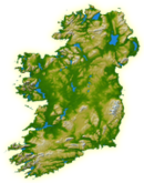
County Down is one of the six counties of Northern Ireland, one of the nine counties of Ulster and one of the traditional thirty-two counties of Ireland. It covers an area of 961 sq mi (2,490 km2) and has a population of 552,261. It borders County Antrim to the north, the Irish Sea to the east, County Armagh to the west, and County Louth across Carlingford Lough to the southwest.

<span class="mw-page-title-main">Dundrum, County Down</span> Village in County Down, Northern Ireland

Dundrum is a village and townland in County Down, Northern Ireland. It is beside Dundrum Bay, about 4 miles outside Newcastle on the A2 road. The village is best known for its ruined Norman castle. It had a population of 1,555 people at the 2011 Census.

<span class="mw-page-title-main">Ardglass</span> Fishing village in County Down, Northern Ireland

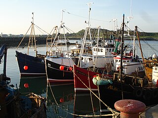
Ardglass is a coastal fishing village, townland and civil parish in County Down, Northern Ireland, in the historic barony of Lecale Lower. It is still a relatively important fishing harbour. It is situated on the B1 Ardglass to Downpatrick road, about 6 miles to the south east of Downpatrick, in the Lecale peninsula on the Irish Sea. It had a population of 1,668 in the 2001 Census, and is located within the Newry, Mourne and Down area.

<span class="mw-page-title-main">Ulaid</span> Ancient Irish kingdom

Ulaid or Ulaidh was a Gaelic over-kingdom in north-eastern Ireland during the Middle Ages made up of a confederation of dynastic groups. Alternative names include Ulidia, which is the Latin form of Ulaid, and in Cóiced, Irish for "the Fifth". The king of Ulaid was called the rí Ulad or rí in Chóicid.

<span class="mw-page-title-main">John de Courcy</span> Anglo-Norman knight

Sir John de Courcy (1150–1219) was an Anglo-Norman knight who arrived in Ireland in 1176. From then until his expulsion in 1204, he conquered a considerable territory, endowed religious establishments, built abbeys for both the Benedictines and the Cistercians and built strongholds at Dundrum Castle in County Down and Carrickfergus Castle in County Antrim.

<span class="mw-page-title-main">Down Cathedral</span>

Down Cathedral, the Cathedral Church of the Holy and Undivided Trinity, is a Church of Ireland cathedral located in the town of Downpatrick in Northern Ireland. It stands on Cathedral Hill overlooking the town. It is one of two cathedrals in the Diocese of Down and Dromore. The cathedral is the centre point of Downpatrick, a relatively new name for the settlement, having only come into usage in the seventeenth century.

<span class="mw-page-title-main">River Quoile</span> River in County Down, Northern Ireland

<span class="mw-page-title-main">Dál nAraidi</span> Middle Ages Cruthin kingdom in Ireland

Dál nAraidi or Dál Araide, sometimes latinised as Dalaradia or anglicised as Dalaray, was a Cruthin kingdom, or possibly a confederation of Cruthin tribes, in north-eastern Ireland during the Middle Ages. It was part of the over-kingdom of Ulaid, and its kings often contended with the Dál Fiatach for the over-kingship of the province. At its greatest extent, the borders of Dál nAraidi roughly matched those of County Antrim, and they seemed to occupy the same area as the earlier Robogdii of Ptolemy's Geography, a region shared with Dál Riata. Their capital was Ráth Mór outside Antrim, and their eponymous ancestor is claimed as being Fiachu Araide.

<span class="mw-page-title-main">Dál Fiatach</span> Gaelic dynastic-grouping and territory

Dál Fiatach was a Gaelic dynastic-grouping and the name of their territory in the north-east of Ireland, which lasted throughout the Middle Ages until their demise in the 13th century at the hands of Normans. It was part of the over-kingdom of Ulaid, and they were its main ruling dynasty for most of Ulaid's history. Their territory lay in eastern County Down. Their capital was Dún Lethglaise (Downpatrick) and from the 9th century their main religious site was Bangor Abbey.

<span class="mw-page-title-main">Earldom of Ulster</span>

The Earldom of Ulster was an Anglo-Norman lordship in north-eastern Ireland during the Middle Ages, ruled by the Earls of Ulster and part of the Lordship of Ireland. The Norman knight John de Courcy invaded the Gaelic Irish kingdom of Ulaid in 1177 and conquered most of its territory over the following few years. In 1181 he was made earl palatine of Ulster by Henry II of England. The earldom was the most important Anglo-Norman lordship in the north of Ireland. It covered most of what are now the Ulster counties of Antrim and Down, and briefly extended west to Lough Foyle. Its capital was Carrickfergus Castle.

Eochaid mac Fiachnai was a Dal Fiatach king of Ulaid, which is now Ulster, Ireland. He was the son of Fiachnae mac Áedo Róin, a previous king. He ruled from 790 to 810.

<span class="mw-page-title-main">Dufferin (barony)</span> Place in Northern Ireland, United Kingdom

Dufferin is a historic barony in County Down, Northern Ireland. It is on the southern half of the west shore of Strangford Lough, and is bordered by three other baronies: Castlereagh Lower to the north; Castlereagh Upper to the west; and Lecale Lower to the south.

<span class="mw-page-title-main">Ards (territory)</span> Place in Ulster, Ireland

Ards is the name of several different historical territorial divisions all located on the Ards Peninsula in modern-day County Down, Northern Ireland.

<span class="mw-page-title-main">Lecale Lower</span> Place in Northern Ireland, United Kingdom

Lecale Lower is a barony in County Down, Northern Ireland. It lies to the east of the county with Strangford Lough to its north and the Irish Sea to its right. It is bordered by five other baronies: Lecale Upper to the south; Ards Upper to the north-east just across the mouth of Strangford Lough; Dufferin to the north; Castlereagh Upper to the north-west; and Kinelarty to the west.

<span class="mw-page-title-main">Lecale Upper</span> Place in Northern Ireland, United Kingdom

Lecale Upper is a barony in County Down, Northern Ireland. To its south lies the Irish Sea, and it is bordered by three other baronies; Lecale Lower and Kinelarty to the north; and Iveagh Upper, Lower Half to the west.

<span class="mw-page-title-main">Kinelarty</span> Place in Northern Ireland, United Kingdom

Kinelarty is a former Irish district and barony in County Down, Northern Ireland. It lies east of the centre of the county, and is bordered by five other baronies: Iveagh Upper, Lower Half to the west; Lecale Upper to the south and south-east; Lecale Lower to the east; Castlereagh Upper to the north; and Iveagh Lower, Upper Half to the north-west.

Blathewyc or Blathewic is the name of several historical territorial divisions in what is now County Down, Northern Ireland. It is the anglicised name of an ancient Irish túath, ruled by the Uí Blathmaic, later becoming a barony, bailiwick, and county in the Anglo-Norman Earldom of Ulster.

Dál mBuinne, alias Dál mBuain, meaning the "portion of Buinne", was a medieval Irish Cruthin petty-kingdom that was part of Dál nAraidi of Magh Line in the over-kingdom of Ulaid. Their eponymous ancestor was Buinn, son of the legendary Ulaid king Fergus mac Róich. It consisted in whole or part of a trícha cét. Dál mBuinne is Anglicised as Dalmunia and Dalboyn, the latter of which became the name of a medieval deanery.

References

  1. Lecale Lower. Place Names NI. Retrieved: 2023-09-18.
  2. 1 2 "Database of Irish Historical Statistics - Literacy Notes" (PDF). esds.ac.uk. Retrieved 19 April 2018.
  3. Stopford Green, Alice (1912). The Old Irish World. Dublin: M. H. Gill and Son. p. 130. Retrieved 21 November 2012.
  4. 1 2 3 4 5 Ireland's History in Maps - Ancient Ulaidh, Ulidia, the Kingdom of Ulster
  5. 1 2 3 "Lecale Historical Society, Downpatrick, County Down". www.lecalehistory.co.uk. Retrieved 19 April 2018.
  6. Lowry, DE (1925–26). Norsemen and Danes of Strangford Lough (reprinted from Proceedings of Belfast Natural History and Philosophical Society). p. 26.
  7. 1 2 3 4 eBooka - James O'Laverty. An historical account of the Diocese of Down and Connor, ancient and modern.
  8. 1 2 3 Ulster Place Names Archived 22 May 2011 at the Wayback Machine - Down Council Area, page 51.
  9. MacGeoghegan, [James] 1802-1763 [from old catalog; O'Kelly, Patrick (19 April 2018). "The history of Ireland, ancient and modern". Dublin, J. Duffy. Retrieved 19 April 2018 via Internet Archive.
  10. James O'Laverty (19 April 1878). "An Historical Account of the Diocese of Down and Connor, Ancient and Modern" . Retrieved 19 April 2018 via Internet Archive.
  11. Crolly, George (1851). Life of the Most Rev. Doctor Crolly. Dublin: James Duffy. pp. vi-vii
  12. Bardon, Jonathan, A History of Ulster, page 45. The Black Syaff Press, 2005, citing Orpen in RSAI Jn, part 1, vol 43 (March 1913), p. 31. ISBN   0-85640-764-X
  13. Bell, Robert; The book of Ulster surnames, page 60. The Black Staff Press, 2003. ISBN   0-85640-602-3
  14. "Lecale Coast AONB". ehsni.gov.uk. Retrieved 19 April 2018.

54°18′N5°39′W / 54.30°N 5.65°W / 54.30; -5.65