
Ulaid or Ulaidh was a Gaelic over-kingdom in north-eastern Ireland during the Middle Ages made up of a confederation of dynastic groups. Alternative names include Ulidia, which is the Latin form of Ulaid, and in Cóiced, Irish for 'the Fifth'. The king of Ulaid was called the rí Ulad or rí in Chóicid.

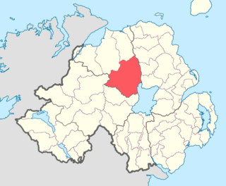
Dál nAraidi or Dál Araide, sometimes latinised as Dalaradia or anglicised as Dalaray, was a Cruthin kingdom, or possibly a confederation of Cruthin tribes, in north-eastern Ireland during the Middle Ages. It was part of the over-kingdom of Ulaid, and its kings often contended with the Dál Fiatach for the over-kingship of the province. At its greatest extent, the borders of Dál nAraidi roughly matched those of County Antrim, and they seemed to occupy the same area as the earlier Robogdii of Ptolemy's Geography, a region shared with Dál Riata. Their capital was Ráth Mór outside Antrim, and their eponymous ancestor is claimed as being Fiachu Araide.
Mac Maoláin Gaelic-Irish surname.

Coleraine is a barony in County Londonderry, Northern Ireland. It connects to the north-Londonderry coastline, and is bordered by five other baronies: Keenaght to the west; Loughinsholin to the south; North East Liberties of Coleraine, Dunluce Upper, and the Kilconway to the east. Before its creation it was once a territory known as "Firnacreeve".
Loughinsholin is a barony in County Londonderry, Northern Ireland. Its southeast borders the northwest shore of Lough Neagh, and itself is bordered by seven other baronies: Dungannon Upper to the south; Strabane Upper to the west; Keenaght and Coleraine to the north; Kilconway, Toome Upper, and Toome Lower to the east. It was formed largely on the extent of the northern part of the medieval Irish túath of Uí Tuirtri.
Tirkeeran is a barony in County Londonderry, Northern Ireland. It connects to the north-Londonderry coastline, and is bordered by four other baronies: Keenaght to the east; Strabane Lower to the south-east; North West Liberties of Londonderry to the west; and Strabane Upper to the south.

Tirkennedy is a barony in County Fermanagh, Northern Ireland. To its west lies Lower Lough Erne and south Upper Lough Erne, and it is bordered by seven other baronies: Clanawley and Magheraboy to the west; Lurg and Omagh East to the north; Clogher to the east; Magherastephana and Knockninny to the south.

Magheraboy is a barony in County Fermanagh, Northern Ireland. To its east lies Lower Lough Erne, and it is bordered by three other baronies in Northern Ireland: Lurg to the north; Tirkennedy to the east; and Clanawley to the south It also borders two baronies in the Republic of Ireland: Tirhugh to the north; and Rosclogher to the south. The westernmost point of Magheraboy is also the westernmost point of Northern Ireland..

Lurg is a barony situated in the north of County Fermanagh, Northern Ireland. To its south lies Lower Lough Erne, and it is bordered by four other baronies in Northern Ireland: Magheraboy to the south; Tirkennedy to the south-east; Omagh West to the north; and Omagh East to the east. It also borders to the west the barony of Tirhugh in the Republic of Ireland.
Clogher is a barony in County Tyrone, Northern Ireland. It is bordered by four other baronies in Northern Ireland: Omagh East to the north; Dungannon Lower to the east; Magherastephana to the south; and Tirkennedy to the south-west. It also borders two baronies in the Republic of Ireland: Trough and Monaghan both to the south-east.

Dungannon Lower is a historic barony in County Tyrone, Northern Ireland. It was created in 1851 with the splitting of the barony of Dungannon. It is bordered by four other baronies in Northern Ireland: Dungannon Middle to the north; Tiranny to the south-east; Clogher to the west; and Omagh East to the north-west. It is also bordered in the south-west by the barony of Trough in the Republic of Ireland.

Armagh is a barony in County Armagh, Northern Ireland. It lies in the west of the county, bordering County Tyrone with its north-western boundary, and bordering the Republic of Ireland with its southern boundary. It is bordered by five other baronies in Northern Ireland: Tiranny to the west, Dungannon Middle to the north-west, Oneilland West to the north-east, Fews Lower to the east, and Fews Upper to the south-east. It also borders to the south the barony of Cremorne in the Republic of Ireland.

Oneilland is the name of a former barony in County Armagh, present-day Northern Ireland. It covers the northern area of the county bordering the south-eastern shoreline of Lough Neagh. At some stage the barony was divided into Oneilland East and Oneilland West.

Oneilland West is a barony in County Armagh, Northern Ireland. It is also called Clancann, after the Mac Cana clan. It lies in the north of the county on the south-western shore of Lough Neagh and the border of County Tyrone. Oneilland West is bordered by five other baronies: Armagh to the west; Dungannon Middle to the north-west; Oneilland East to the north-east; Orior Lower to the south-east; and Kinelarty to the south.
Oneilland East is a barony in the north-east of County Armagh, Northern Ireland. It is also called Clanbrasil. It lies in the north-east corner of the county, on the south-eastern shore of Lough Neagh and the boundary with County Down. Oneilland East is bordered by three other baronies: Oneilland West to the west; Iveagh Lower to the east; and Orior Lower to the south.

Orior Upper is a barony in County Armagh, Northern Ireland. It lies in the south-east of the county and borders the Republic of Ireland with its southern boundary. It is bordered by five other baronies in Northern Ireland: Fews Upper and an enclave of Fews Lower to the west; Orior Lower to the north; Iveagh Upper, Upper Half to its west, which is divided in two by the Lordship of Newry. It also borders two baronies in the Republic of Ireland: Dundalk Lower and Dundalk Upper to the south.

Mourne is a barony in County Down, Northern Ireland. It lies in the south-east of the county, with the Irish Sea to its east. It is bordered by two other baronies: Iveagh Upper, Lower Half and Iveagh Upper, Upper Half to the north and west. Called at one time Bairrche its present name of Mourne comes from the Múrna, a people who hail from a territory of the same name in modern County Monaghan.

Kinelarty is a former Irish district and barony in County Down, Northern Ireland. It lies east of the centre of the county, and is bordered by five other baronies: Iveagh Upper, Lower Half to the west; Lecale Upper to the south and south-east; Lecale Lower to the east; Castlereagh Upper to the north; and Iveagh Lower, Upper Half to the north-west.

Iveagh is the name of several historical territorial divisions in what is now County Down, Northern Ireland. Originally it was a Gaelic Irish territory, ruled by the Uí Echach Cobo and part of the overkingdom of Ulaid. From the 12th century the Magennises were chiefs of Iveagh. They were based at Rathfriland and were inaugurated at Knock Iveagh. Following the Nine Years' War, the rulers of Iveagh submitted to the English Crown and the territory was divided between them. Iveagh became a barony, which was later split into Iveagh Lower and Iveagh Upper. The territory of Iveagh was also the basis of the Roman Catholic Diocese of Dromore.

