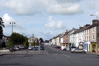
Templemore is a town in County Tipperary, Ireland. It is a civil parish in the historical barony of Eliogarty. It is part of the parish of Templemore, Clonmore and Killea in the Roman Catholic Archdiocese of Cashel and Emly.

Aughagower or Aghagower is a small village in rural County Mayo in western Ireland. It is 6 km south-east of Westport. Aughagower has around forty houses, a pub and a shop, with a clear view of Croagh Patrick from Reek View. It is also at the centre of Aghagower civil parish which covers an area of 86.1 square miles. The village is known for its links to Saint Patrick and Tóchar Phádraig, the pilgrimage route from Ballintubber Abbey to Croagh Patrick.

Cullyhanna is a small village and townland in County Armagh, Northern Ireland. The village extends further over the townlands of Tullynavall and Freeduff. It had a population of 306 in the 2001 Census. It is within the Newry and Mourne District Council area.

Keady is a village and civil parish in County Armagh, Northern Ireland. It is south of Armagh and near the border with the Republic of Ireland. It is situated mainly in the historic barony of Armagh with six townlands in the barony of Tiranny. It had a population of 3,051 people in the 2011 Census.

Aghagallon (from Irish Achadh Gallan , meaning 'field of the standing stones' is a small village and civil parish in County Antrim, Northern Ireland. It is about three miles northeast of Lurgan, County Armagh, and had a population of 824 in the 2001 census.

Blackwatertown is a small village in County Armagh, Northern Ireland. It sits on the River Blackwater, in the townland of Lisbofin, at the border with County Tyrone. The village is around 8 kilometres (5 mi) north of Armagh city, and the villages of Benburb and Moy are nearby. Blackwatertown had a population of 376 in the 2011 Census. The River Blackwater enters Lough Neagh west of Derrywarragh Island and is navigable from Maghery to Blackwatertown.
Borrisoleigh is a small town in County Tipperary, Ireland. At the 2016 census, it had a population of 679. It is in the ecclesiastical parish of Borrisoleigh and Ileigh in the Roman Catholic Archdiocese of Cashel and Emly.

Tydavnet, officially Tedavnet , is a village in northern County Monaghan, Ireland, and also the name of the townland and civil parish in which the village sits. Both the Church of Ireland and Catholic church have Tydavnet named as a parish and in both cases, the geographical area is almost identical. The village is located on the R186 regional road.
Madden is a small village and townland in County Armagh, Northern Ireland. It is within the Armagh City, Banbridge and Craigavon Borough Council area. It has a population of around 200 people.

Kilcloon or Kilclone is a parish situated in the south-east of County Meath in Ireland. Kilcloon parish is largely rural and contains the village of Kilcloon itself and the neighbouring villages of Batterstown and Mulhussey. The parish church is located at Ballynare Cross Roads in the village of Kilcloon with chapels in Kilcock and Batterstown.

The Diocese of Armagh is the metropolitan diocese of the ecclesiastical province of Armagh, the Church of Ireland province that covers the northern half (approximately) of the island of Ireland. The diocese mainly covers counties Louth, Tyrone and Armagh, and parts of Down. The diocesan bishop is also the Archbishop of Armagh, the archbishop of the province, and the Primate of All Ireland. The Archbishop has his seat in St Patrick's Cathedral in the town of Armagh.

Killyman is a small village and a civil parish in Northern Ireland, situated on the eastern boundary of County Tyrone and extending into County Armagh. The majority of townlands are in the historic barony of Dungannon Middle in County Tyrone, the rest being in the barony of Oneilland West in County Armagh.

Granemore is a townland of 785 acres in County Armagh, Northern Ireland, about seven miles from Armagh and three miles from Keady. It is situated in the civil parish of Keady and historic barony of Armagh.
Ballymacnab is a townland and village in County Armagh, Northern Ireland. It is within the civil parish of Kilclooney, four miles south of the City of Armagh on the road towards Newtownhamilton. It is within the Armagh City and District Council area.

Tiranny is a barony in County Armagh, Northern Ireland. It lies on the western boundary of the county, bordering County Tyrone to its west and County Monaghan in the Republic of Ireland to its south. It is bordered by three other baronies in Northern Ireland: Dungannon Lower and Dungannon Upper to the north-west; and Armagh to the east. It also borders two baronies in the Republic of Ireland; Cremorne to the south and Trough to the west.
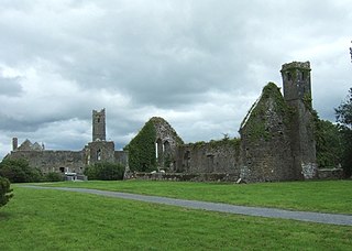
Quin is a village in southeast County Clare, Ireland. The name also refers to a civil parish in the barony of Bunratty Upper, and to an ecclesiastical parish of the same name. The main attraction in the vicinity is Quin Abbey, the ruins of Franciscan friary, which is open to the public. Although roofless, much of the structure remains and is relatively well-preserved. The abbey was built on the foundations of an earlier Norman castle; the foundations of three corner towers can still be seen.
Herbertstown is a village in south-eastern County Limerick, Ireland. It is part of the ecclesiastical parish of "Hospital and Herbertstown", in the Roman Catholic Archdiocese of Cashel and Emly. Herbertstown is in the centre of the electoral division of Cahercorney stretching from Ballingoola in the north-east, Ballyloundash in the east and Kilcullane in the south.

Noughaval or Nohoval is a civil parish in County Clare, Ireland.

Annaghmore is a small village and townland near Loughgall in County Armagh, Northern Ireland. It is situated in the civil parish of Loughgall and the historic barony of Oneilland West. It had a population of 265 people in the 2011 Census.


