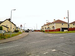
Craigavon is a town in northern County Armagh, Northern Ireland. Its construction began in 1965 and it was named after the first Prime Minister of Northern Ireland: James Craig, 1st Viscount Craigavon. It was intended to be the heart of a new linear city incorporating Lurgan and Portadown, but this plan was mostly abandoned and later described as having been flawed. Among local people today, "Craigavon" refers to the area between the two towns. It is built beside a pair of artificial lakes and is made up of a large residential area (Brownlow), a second smaller one (Mandeville), plus a central area (Highfield) that includes a substantial shopping centre, a courthouse and the district council headquarters. The area around the lakes is a public park and wildlife haven made up of woodland with walking trails. There is also a watersports centre, golf course and ski slope in the area. In most of Craigavon, motor vehicles are completely separated from pedestrians, and roundabouts are used extensively. It hosted the headquarters of the former Craigavon Borough Council.

Draperstown is a village in the Sperrin Mountains in County Londonderry, Northern Ireland. It is situated in the civil parish of Ballinascreen and is part of Mid-Ulster district. It is also part of the Church of Ireland parish of Ballynascreen and the Catholic parish of Ballinascreen, and within the former barony of Loughinsholin.
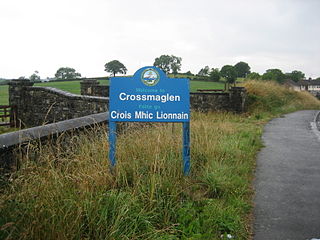
Crossmaglen is a village and townland in County Armagh, Northern Ireland. It had a population of 1,610 in the 2011 Census and is the largest village in South Armagh. The village centre is the site of a large Police Service of Northern Ireland base and formerly of an observation tower.
Julianstown is a village in County Meath, Ireland. It is located near Drogheda on the R132 regional road. In 1641, the Battle of Julianstown was fought here during the Irish Rebellion of 1641.

Loughgall is a small village, townland and civil parish in County Armagh, Northern Ireland. It is in the historic baronies of Armagh and Oneilland West. It had a population of 282 people in the 2011 Census. Loughgall was named after a small nearby loch. The village is surrounded by orchards.

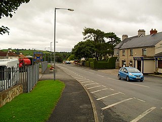
Aghagallon (from Irish Achadh Gallan , meaning 'field of the standing stones' is a small village and civil parish in County Antrim, Northern Ireland. It is about three miles northeast of Lurgan, County Armagh, and had a population of 824 in the 2001 census.
Darkley is a small village and townland near Keady in County Armagh, Northern Ireland. It had a population of 224 people in the 2011 Census.

Ballymoyer or Ballymyre is a civil parish in the historic barony of Fews Upper, County Armagh, Northern Ireland, 3 miles north-east of Newtownhamilton.

Newtownhamilton is a small village and civil parish in County Armagh, Northern Ireland. It lies predominantly within Tullyvallan townland. The civil parish is within the historic barony of Fews Upper. In the 2011 Census it had 2,836 inhabitants.
Richhill is a large village and townland in County Armagh, Northern Ireland. It lies between Armagh and Portadown. It had a population of 2,738 people in the 2021 Census.
Broomhill is a small village in County Armagh, Northern Ireland. It is within the townland of Drumnahunshin and the Armagh City and District Council area. It had a population of 197 people in the 2011 Census.

Kilmore or Killmore is a small village, townland and civil parish in County Armagh, Northern Ireland. It lies 2.5 miles (4 km) north of Richhill and within the Armagh City, Banbridge and Craigavon Borough Council area. It had a population of 190 people in the 2011 Census.

Lisnadill is a hamlet, townland and civil parish in County Armagh, Northern Ireland. In the 2001 Census it had a population of 54 people. It lies about 3 miles south of Armagh and is within the Armagh City and District Council area.
Mountnorris is a small village and townland in County Armagh, Northern Ireland. The village also extends into the townland of Tullyherron. It lies about six miles south of Markethill. It is within the Armagh, Banbridge and Craigavon local government area. It had a population of 155 people in the 2011 Census.

Gibson's Hill or Corcreeny is a small village in the townland of Corcreeny in County Armagh, Northern Ireland, about 1.5 km from Lurgan. It lies on the main Lurgan to Gilford road. In the 2001 Census it had a population of 186 people. It is within the Craigavon Borough Council area.

Belleeks is a small village and townland in south County Armagh, Northern Ireland. In the 2011 Census it had a reported population of 375. It lies within the Newry, Mourne and Down District Council area and the historic barony of Upper Fews.

Mullaghglass is a small village and townland north of Newry in County Armagh, Northern Ireland. It was named after the nearby townland of Mullaghglass, although the village itself is within the townland of Latt. In the 2001 Census it had a population of 135. It is within the Newry and Mourne District Council area.

Killyman is a small village and a civil parish in Northern Ireland, situated on the eastern boundary of County Tyrone and extending into County Armagh. The majority of townlands are in the historic barony of Dungannon Middle in County Tyrone, the rest being in the barony of Oneilland West in County Armagh.
Ballymacnab is a townland and village in County Armagh, Northern Ireland. It is within the civil parish of Kilclooney, four miles south of the City of Armagh on the road towards Newtownhamilton. It is within the Armagh City and District Council area.

Annaghmore is a small village and townland near Loughgall in County Armagh, Northern Ireland. It is situated in the civil parish of Loughgall and the historic barony of Oneilland West. It had a population of 265 people in the 2011 Census.