
Dunadry is a hamlet and townland 3 miles (5 km) from Antrim in County Antrim, Northern Ireland. It is situated in the civil parish of Grange of Nilteen and the historic barony of Antrim Upper. It is within the Antrim and Newtownabbey Borough Council area. It had a population of 430 people in the 2011 Census..

Millisle or Mill Isle is a village on the Ards Peninsula in County Down, Northern Ireland. It is about 3 miles (4.8 km) south of Donaghadee. It is situated in the townlands of Ballymacruise and Ballycopeland, the civil parish of Donaghadee and the historic barony of Ards Lower. It had a population of 2,318 people in the 2011 Census.

Coagh is a small village in County Tyrone, Northern Ireland, five miles (8 km) east of Cookstown. Part of the village also extends into County Londonderry. It had a population of 545 people in the 2001 Census. It owes its existence to George Butle Conyngham of Springhill, and was founded in 1728 when King George II of Great Britain granted Conyngham a market charter allowing the village to host four fairs yearly. It is situated within Mid-Ulster District.

Claudy is a village and townland in County Londonderry, Northern Ireland. It lies in the Faughan Valley, 6 miles (9.7 km) southeast of Derry, where the River Glenrandal joins the River Faughan. It is situated in the civil parish of Cumber Upper and the historic barony of Tirkeeran. It is also part of Derry and Strabane district.

Ballystrudder or Ballystruder is a small village and townland on Islandmagee in County Antrim, Northern Ireland. It is situated in the historic barony of Belfast Lower and the civil parish of Islandmagee. It is part of Mid and East Antrim Borough Council. It had a population of 992 people in the 2011 Census.

Dervock is a small village and townland in County Antrim, Northern Ireland. It is about 3.5 miles (6 km) northeast of Ballymoney, on the banks of the River Bush. It is situated in the civil parish of Derrykeighan and the historic barony of Dunluce Lower. It had a population of 714 people in the 2011 Census.

Tynan is a village, townland and civil parish in County Armagh, Northern Ireland. It is situated largely in the historic barony of Tiranny, with some areas in the barony of Armagh, around 11 kilometres (7 mi) west of Armagh City.
Groggan is a hamlet and townland near Randalstown in County Antrim, Northern Ireland. It is situated in the historic barony of Toome Upper and the civil parish of Drummaul and covers an area of 620 acres. It is within the Borough of Antrim.
Balloo is a small village and townland near Killinchy in County Down, Northern Ireland. It is 5 miles south of Comber on the A22 road between Belfast and Downpatrick. It is situated in the townland of the same name, the civil parish of Killinchy and the historic barony of Dufferin. It lies within the Ards and North Down Borough. It had a population of 189 people in the 2011 Census.

Whiterock is a small village in County Down, Northern Ireland. It is within the townland of Killinakin, in the civil parish of Killinchy and historic barony of Dufferin, on the western shore of Strangford Lough, near to the village of Killinchy. It is in the Ards and North Down Borough. It had a population of 355 people in the 2011 Census.
Broomhill is a small village in County Armagh, Northern Ireland. It is within the townland of Drumnahunshin and the Armagh City and District Council area. It had a population of 197 people in the 2011 Census.

Loughgilly is a small village, townland and civil parish in County Armagh, Northern Ireland. It is on the main Armagh to Newry road, about halfway between the two. It is within the Armagh City and District Council area. It had a population of 84 people in the 2011 Census.
Corbet is a small village and townland in County Down, Northern Ireland, 5 km east of Banbridge. It is situated in the civil parish of Magherally and the historic barony of Iveagh Lower, Lower Half. It lies within the Banbridge District. It had a population of 107 people in the 2011 Census.

Caledon is a small village and townland in County Tyrone, Northern Ireland. It is in the Clogher Valley on the banks of the River Blackwater, 10 km from Armagh. It lies in the southeast of Tyrone and near the borders of County Armagh and County Monaghan. It is situated in the historic barony of Dungannon Lower and the civil parish of Aghaloo. In the 2001 Census it had a population of 387 people. It is a designated conservation area. It was historically known as Kinnaird.

Lack is a small village and townland in County Fermanagh, Northern Ireland, 5.5 km east-north-east of Ederny. It is situated in the civil parish of Magheraculmoney and the historic barony of Lurg. It had a population of 111 people in the 2011 Census..
Mullaghboy is a small village and townland on Islandmagee in County Antrim, Northern Ireland. It is situated in the civil parish of Islandmagee and the historic barony of Belfast Lower. It is within the Larne Borough Council area. It had a population of 364 people in the 2011 Census..

Drumnakilly .) is a small village and townland between Carrickmore and Omagh in County Tyrone, Northern Ireland. In the 2001 Census it had a population of 114 people. The townland is situated in the historic barony of Strabane Upper and the civil parish of Termonmaguirk and covers an area of 1,352 acres. It lies within the Omagh District Council area.
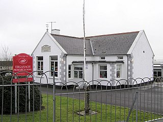
Erganagh is a small village and townland near Castlederg in County Tyrone, Northern Ireland. It is situated in the historic barony of Strabane Lower and the civil parish of Ardstraw. In the 2001 Census it had a population of 366 people. It is within the Strabane District Council area.
Ballyrory is a small village and townland in County Londonderry, Northern Ireland. It is situated in the civil parish of Cumber Upper and the historic barony of Tirkeeran.

Annaghmore is a small village and townland near Loughgall in County Armagh, Northern Ireland. It is situated in the civil parish of Loughgall and the historic barony of Oneilland West. It had a population of 265 people in the 2011 Census.


