Lurgan is a town in County Armagh, Northern Ireland, near the southern shore of Lough Neagh and roughly 18 miles (29 km) southwest of Belfast. The town is linked to Belfast by both the M1 motorway and the Belfast–Dublin railway line. Lurgan had a population of about 28,634 at the 2021 UK census, and falls within the Armagh, Banbridge and Craigavon district. For certain purposes, Lurgan is treated as part of the "Craigavon Urban Area", along with neighbouring Craigavon and Portadown.

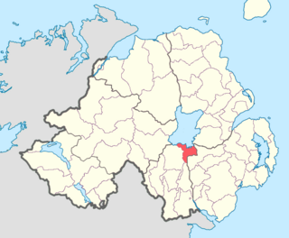
Portadown is a town in County Armagh, Northern Ireland. The town sits on the River Bann in the north of the county, about 24 mi (39 km) southwest of Belfast. It is in the Armagh City, Banbridge and Craigavon Borough Council area and had a population of about 32,000 at the 2021 Census. For some purposes, Portadown is treated as part of the "Craigavon Urban Area", alongside Craigavon and Lurgan.

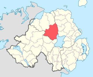
Craigavon is a town in northern County Armagh, Northern Ireland. Its construction began in 1965 and it was named after the first Prime Minister of Northern Ireland: James Craig, 1st Viscount Craigavon. It was intended to be the heart of a new linear city incorporating Lurgan and Portadown, but this plan was mostly abandoned and later described as having been flawed. Among local people today, "Craigavon" refers to the area between the two towns. It is built beside a pair of artificial lakes and is made up of a large residential area (Brownlow), a second smaller one (Mandeville), plus a central area (Highfield) that includes a substantial shopping centre, a courthouse and the district council headquarters. The area around the lakes is a public park and wildlife haven made up of woodland with walking trails. There is also a watersports centre, golf course and ski slope in the area. In most of Craigavon, motor vehicles are completely separated from pedestrians, and roundabouts are used extensively. It hosted the headquarters of the former Craigavon Borough Council.

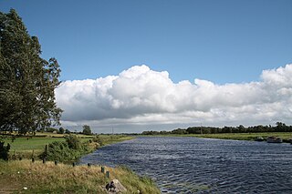
The River Bann is the longest river in Northern Ireland, its length, Upper and Lower Bann combined, being 129 km (80 mi). However, the total length of the River Bann, including its path through the 30 km (19 mi) long Lough Neagh is 159 km (99 mi). Another length of the River Bann given is 90 mi. The river winds its way from the southeast corner of Ulster to the northwest coast, pausing in the middle to widen into Lough Neagh. The River Bann catchment has an area of 5,775 km2. The River Bann has a mean discharge rate of 92 m3/s. According to C. Michael Hogan, the Bann River Valley is a settlement area for some of the first human arrivals in Ireland after the most recent glacial retreat.
Craigavon Borough Council was a local council in counties Armagh, Down and Antrim, in Northern Ireland. It merged with Armagh City and District Council and Banbridge District Council in May 2015 under local government reorganisation in Northern Ireland to become Armagh, Banbridge and Craigavon District Council.

Greenisland is a town in County Antrim, Northern Ireland. It lies 7 miles north-east of Belfast and 3 miles south-west of Carrickfergus. The town is on the coast of Belfast Lough and is named after a tiny islet to the west, the Green Island.
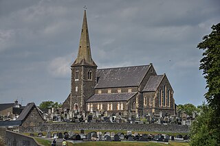
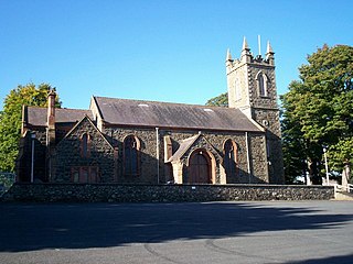
Drumcree Parish Church, officially The Church of the Ascension, is the Church of Ireland parish church of Drumcree in County Armagh, Northern Ireland. It sits on a hill in the townland of Drumcree, outside Portadown. It is a site of historic significance and is a listed building.

The Newry Canal is an abandoned canal in Northern Ireland. Opened in 1742, it was built to link the Tyrone coalfields to the Irish Sea. The navigable route ran from Lough Neagh via the Upper Bann river to Portadown, then approximately 20 miles from Portadown via the canal proper to Newry, terminating in the Albert Basin.

Killinchy is a townland and small village in County Down, Northern Ireland. It is two miles inland from the western shores of Strangford Lough in the Borough of Ards and North Down. It is situated in the townland of the same name, the civil parish of Killinchy and the historic barony of Dufferin. It had a population of 539 people in the 2011 Census.
Toome or Toomebridge is a small village and townland on the northwest corner of Lough Neagh in County Antrim, Northern Ireland. It lies in the civil parish of Duneane in the former barony of Toome Upper, and is in the Antrim and Newtownabbey Borough Council area. It had a population of 781 in the 2011 census.

The Belfast–Newry line operates from Lisburn station in County Antrim to Newry in County Down, Northern Ireland. The manager for this line is based at Portadown railway station, although the line extends to the border to include the Scarva and Poyntzpass halts and Newry. Newry is on the fringe of the network, being the last stop before the border with the Republic of Ireland. The line follows the route of the northern half of the main Dublin–Belfast line.

Tullylish is a small village, townland and civil parish in County Down, Northern Ireland. It sits on the River Bann, along the main road between the towns of Banbridge and Portadown. In the 2001 Census it had a population of 105 people. It lies within the civil parish of Tullylish and Banbridge District.
The Birches is a small village in northern County Armagh, Northern Ireland. It is 6 miles northwest of Portadown, close to junction 12 on the M1 Motorway and to the southern shore of Lough Neagh. In the 2001 Census it had a population of 150. It is within the Armagh City, Banbridge and Craigavon council area.
Derryvore is the name of three townlands in Northern Ireland.
Bannfoot is a small village in the townland of Derryinver, County Armagh, Northern Ireland. It sits where the Upper Bann flows into Lough Neagh.
Kilcronaghan is a civil parish in County Londonderry, Northern Ireland. Containing one major settlement, Tobermore, and lying on the descending slope of Slieve Gallion, Kilcronaghan is bordered by the civil parishes of Ballynascreen, Desertmartin, Maghera, and Termoneeny. It lies within the former historic barony of Loughinsholin and is situated in Mid-Ulster District. As an ecclesiastical parish it lies within the Diocese of Derry and Raphoe.
Loughinsholin is a barony in County Londonderry, Northern Ireland. Its southeast borders the northwest shore of Lough Neagh, and itself is bordered by seven other baronies: Dungannon Upper to the south; Strabane Upper to the west; Keenaght and Coleraine to the north; Kilconway, Toome Upper, and Toome Lower to the east. It was formed largely on the extent of the northern part of the medieval Irish túath of Uí Tuirtri.
Oneilland East is a barony in the north-east of County Armagh, Northern Ireland. It is also called Clanbrasil. It lies in the north-east corner of the county, on the south-eastern shore of Lough Neagh and the boundary with County Down. Oneilland East is bordered by three other baronies: Oneilland West to the west; Iveagh Lower to the east; and Orior Lower to the south.

Saint Gobhan has long been linked with the parish of Seagoe – recorded for instance as Teach dho-Ghobha – in County Armagh, Ireland.
Seagoe parish or St Gobhan's parish is an ecclesiastical parish of the Church of Ireland that is located in Portadown, County Armagh, Northern Ireland. It is on one of the oldest recorded sites of Christianity in Ireland. Christian links to the area date back to the early 500 AD's. It was founded by St. Gobhan.

