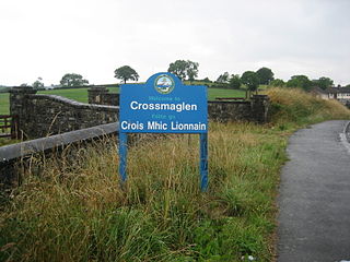
Crossmaglen is a village and townland in County Armagh, Northern Ireland. It had a population of 1,610 in the 2011 Census and is the largest village in South Armagh. The village centre is the site of a large Police Service of Northern Ireland base and formerly of an observation tower.

Armagh City and District Council was a district council in County Armagh in Northern Ireland. It merged with Banbridge District Council and Craigavon Borough Council in May 2015 under local government reorganisation in Northern Ireland to become Armagh, Banbridge and Craigavon District Council.

Cullyhanna is a small village and townland in County Armagh, Northern Ireland. The village extends further over the townlands of Tullynavall and Freeduff. It had a population of 306 in the 2001 Census. It is within the Newry and Mourne District Council area.

Greencastle is a hamlet in County Tyrone, Northern Ireland. It is within the townland of Sheskinshule.

The Athletic Grounds, known for sponsorship reasons as the BOX-IT Athletic Grounds, is a GAA stadium in Armagh, Northern Ireland. It is the county ground and administrative headquarters of Armagh GAA and is used for both Gaelic football and hurling.

Forkhill or Forkill is a small village and civil parish in south County Armagh, Northern Ireland. It is within the Ring of Gullion and in the 2011 Census it had a recorded population of 498. The population increased to 550 at the time of the 2021 Census. Forkhill was the settlement with the highest percentage of residents that identified as "Irish Only" in the 2021 census, 80.55%, 2.18% were "British Only". It lies within the former barony of Orior Upper.

Blackwatertown is a small village in County Armagh, Northern Ireland. It sits on the River Blackwater, in the townland of Lisbofin, at the border with County Tyrone. The village is around 8 kilometres (5 mi) north of Armagh city, and the villages of Benburb and Moy are nearby. Blackwatertown had a population of 376 in the 2011 Census. The River Blackwater enters Lough Neagh west of Derrywarragh Island and is navigable from Maghery to Blackwatertown.

Middletown is a small village and townland in County Armagh, Northern Ireland. It lies near the border with County Monaghan, between Armagh and Monaghan along the A3. It had a population of 237 people in the 2011 Census.

Kilmore or Killmore is a small village, townland and civil parish in County Armagh, Northern Ireland. It lies 2.5 miles (4 km) north of Richhill and within the Armagh City, Banbridge and Craigavon Borough Council area. It had a population of 190 people in the 2011 Census.

Belleeks is a small village and townland in south County Armagh, Northern Ireland. In the 2011 Census it had a reported population of 375. It lies within the Newry, Mourne and Down District Council area and the historic barony of Upper Fews.

Cullaville or Culloville (from Irish Baile Mhic Cullach, meaning 'MacCullach's townland' or McCulloch's ville or town is a small village and townland near Crossmaglen in County Armagh, Northern Ireland. It is the southernmost settlement in the county and one of the southernmost in Northern Ireland, straddling the Irish border. In the 2001 Census it had a population of 400 people. The village is on a busy crossroads on the main Dundalk to Castleblaney road ; three of the roads lead across the border and the fourth leads to Crossmaglen.
Dromintee or Drumintee is a small village and townland in County Armagh, Northern Ireland. In the 2001 Census it had a population of 364 people. It lies within the Newry and Mourne District Council area. It sits within the Ring of Gullion AONB.

Lislea is a small village and townland near Slieve Gullion in County Armagh, Northern Ireland. It is within the civil parish of Killevy and the historic barony of Orior Upper. Today it is within the Newry, Mourne and Down District Council area. It borders the townlands of Ballard, Carricnagalliagh, Aghmakane, Duburren and Drumilly. In the 2001 Census it had a population of 84 people.

Derrynoose is a village and civil parish in south County Armagh, Northern Ireland, 4.5 km south-west of Keady.

Mullaghbawn, or Mullaghbane, is a small village and townland near Slieve Gullion in County Armagh, Northern Ireland. In the 2011 Census it had a population of 596. At the 2021 Census this had risen to 642.

Aughanduff is a small village and townland in the civil parish of Forkhill, in the former barony of Orior Upper, and County of Armagh, Northern Ireland. The townland is roughly co-existent with Upper and Lower Aughanduff Mountains, both of which form part of the Ring of Gullion geological formation, which has been described as the most spectacular example of a ring-dyke intrusion in Ireland or Britain, and was the first ring dyke in the world to be geologically mapped. Aughanduff has been populated since prehistoric times and has been recorded as a distinct district since at least the early 1600s. The area's history is both well documented and reflects its location both in rural Ireland and on the borderlands of the Pale, the Plantation of Ulster, and latterly Northern Ireland; indeed, part of the district's northern boundary was proposed for forming part of the northern border of the Irish Free State by the Irish Boundary Commission in its final report of 1925. The Boundary Commission's report was never implemented and today, the area remains within Northern Ireland, some five miles from the border with the Republic of Ireland. Part of the area has been designated by the Northern Ireland Environment Agency as an Area of Special Scientific Interest, and the district lies within the Ring of Gullion Area of Outstanding Natural Beauty.
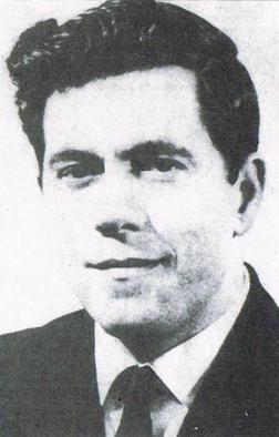
Robert William McConnell, was a Protestant murder victim of the IRA in South Armagh, later alleged to be a Ulster loyalist paramilitary who carried out or was an accomplice to a number of sectarian attacks and killings, although he never faced any charges or convictions. McConnell served part-time as a corporal in the 2nd Battalion Ulster Defence Regiment (UDR), and whilst no evidence has been presented he is alleged to have been a member of the Ulster Volunteer Force (UVF).

Silverbridge Harps Gaelic Football Club is a Gaelic football club in southern County Armagh, Northern Ireland. It is based in the parish of Upper Creggan, including the village of Silverbridge and surrounding townlands. Silverbridge plays at Keeley Park, as part of the Armagh GAA and is currently in the Armagh Intermediate Football Championship.

Annaghmore is a small village and townland near Loughgall in County Armagh, Northern Ireland. It is situated in the civil parish of Loughgall and the historic barony of Oneilland West. It had a population of 265 people in the 2011 Census.
During the evening of 19 December 1975, two coordinated attacks were carried out by the Ulster Volunteer Force (UVF) in pubs either side of the Irish border. The first attack, a car bombing, took place outside Kay's Tavern, a pub along Crowe Street in Dundalk, County Louth, Republic of Ireland - close to the border. The second, a gun and bomb attack, took place at Donnelly's Bar & Filling Station in Silverbridge, County Armagh, just across the border inside Northern Ireland. The attack has been linked to the Glenanne gang, a group of loyalist militants who were either members of the UVF, the Ulster Defence Regiment (UDR), the Royal Ulster Constabulary (RUC) and the closely linked UVF paramilitary the Red Hand Commando (RHC), some of the Glenanne gang were members of two of these organizations at the same time like gang leaders Billy Hanna who was in both the UVF and the UDR and who fought for the British Army during the Korean War and John Weir who was in the UVF and was a sergeant in the RUC. At least 25 UDR men and police officers were named as members of the gang. The Red Hand Commando claimed to have carried out both attacks.


