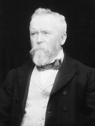
Mullaghbrack

Last updated

St. John's Church, in Mullaghbrack, lies between Hamiltonsbawn and Markethill St. John's Parish Church, Mullabrack - geograph.org.uk - 1000067.jpg
St. John's Church, in Mullaghbrack, lies between Hamiltonsbawn and Markethill

Mullaghbrack, Mullabrack or Mullaghbrac (from Irish An Mullach Breac, meaning 'speckled hilltop') [1] is a small civil parish, townland and village in County Armagh, Northern Ireland. The village of Mullaghbrack is on the road between Markethill and Hamiltonsbawn, just north of Gosford Forest Park. It had a population of 54 people (24 households) in the 2011 census, [2] down from 75 people as of the 2001 census.[ citation needed ]

Contents

Geography

The civil parish of Mullaghbrack (Irish : An Mullach Breac) spans the historic baronies of Fews Lower and Oneilland West in County Armagh. [3] There are 43 townlands in the civil parish, [4] including smaller townlands like Mullaghbrack townland itself (254 acres (1.03 km2)) [5] and slightly larger townlands like Drumnamether (389 acres (1.57 km2)). [6] Larger settlements in the civil parish include Markethill. [7]

History

In the 5th century, a simple wooden church was built at Mullaghbrack, within the remains of an ancient earthen-ringed fort. This church is associated with the Culdee Priors of Armagh, who are sometimes regarded as "the successors of St Patrick". [8]

The area was impacted during the Irish Rebellion of 1641. Irish commander Féilim Ó Néill, on his march from Newry to Armagh in 1641, reputedly ordered Mulmory MacDonell "... to kill all the English and Scots within the parishes of Mullebrack, Logilly and Kilcluney". [9] Among the properties destroyed in the Markethill area were the parish churches of Mullaghbrack and Kilcluney, Achesons Castle at Markethill and Hamilton's bawn. The rectors of Mullaghbrack (Reverend Mercer) and Loughgilly (Reverend Burns) were both killed. [10]

Sport

The local Gaelic Athletic Association (GAA) club is O'Donovan Rossa's (Cumann Uí Dhonnabháin Rossa), founded in 1903 as the Shamrocks; it disappeared in the 1930s but was reformed under its present name in 1953. The high point in the club's history was its winning the county Junior championship in 1983. [11]

People

See also

Related Research Articles

<span class="mw-page-title-main">Aghagallon</span> Village in County Antrim, Northern Ireland

Aghagallon (from Irish Achadh Gallan , meaning 'field of the standing stones' is a small village and civil parish in County Antrim, Northern Ireland. It is about three miles northeast of Lurgan, County Armagh, and had a population of 824 in the 2001 census.

<span class="mw-page-title-main">Markethill</span> Village in County Armagh, Northern Ireland

Markethill is a village in County Armagh, Northern Ireland. It is beside Gosford Forest Park. It had a population of 1,647 people in the 2011 census.

<span class="mw-page-title-main">Loughgilly</span> Village in County Armagh, Northern Ireland

Loughgilly is a small village, townland and civil parish in County Armagh, Northern Ireland. It is on the main Armagh to Newry road, about halfway between the two. It is within the Armagh City and District Council area. It had a population of 84 people in the 2011 Census.

<span class="mw-page-title-main">Mountnorris</span> Village in County Armagh, Northern Ireland

Mountnorris is a small village and townland in County Armagh, Northern Ireland. The village also extends into the townland of Tullyherron. It lies about six miles south of Markethill. It is within the Armagh, Banbridge and Craigavon local government area. It had a population of 155 people in the 2011 Census. Ulsterbus offers 1 stop in mountnorris. (2001 Census: 165 people

<span class="mw-page-title-main">Mullaghglass</span> Village in County Armagh, Northern Ireland

Mullaghglass is a small village and townland north of Newry in County Armagh, Northern Ireland. It was named after the nearby townland of Mullaghglass, although the village itself is within the townland of Latt. In the 2001 Census it had a population of 135. It is within the Newry and Mourne District Council area.

<span class="mw-page-title-main">Diocese of Armagh (Church of Ireland)</span> Anglican diocese of the Church of Ireland

The Diocese of Armagh is the metropolitan diocese of the ecclesiastical province of Armagh, the Church of Ireland province that covers the northern half (approximately) of the island of Ireland. The diocese mainly covers counties Louth, Tyrone and Armagh, and parts of Down. The diocesan bishop is also the Archbishop of Armagh, the archbishop of the province, and the Primate of All Ireland. The Archbishop has his seat in St Patrick's Cathedral in the town of Armagh.

<span class="mw-page-title-main">Mullaghbawn</span> Village in County Armagh, Northern Ireland

Mullaghbawn, or Mullaghbane, is a small village and townland near Slieve Gullion in County Armagh, Northern Ireland. In the 2011 Census it had a population of 596. At the 2021 Census this had risen to 642.

<span class="mw-page-title-main">Granemore</span> Human settlement in Northern Ireland

Granemore is a townland of 785 acres in County Armagh, Northern Ireland, about seven miles from Armagh and three miles from Keady. It is situated in the civil parish of Keady and historic barony of Armagh.

<span class="mw-page-title-main">New Inn, County Galway</span> Village in Connacht, Ireland

"New Inn" is a village in east County Galway, Ireland. It lies mostly within the townland of Knockbrack, 14 km (8.7 mi) northeast of Loughrea. The village is on the Eiscir Riada, a series of hills which stretches across the Great Plains of Ireland. There are many ancient forts or raths scattered throughout the parish, as represented in local placenames such as Rathally and Rathglass. The townland of Grange, to the west of New Inn, contains a cemetery wherein lies the ruins of a Cistercian monastery. The Dunkellin River flows through New Inn and rises in nearby Woodlawn.

<span class="mw-page-title-main">Danesfort</span> Townland in County Kilkenny, Ireland

Danesfort is a rural townland and electoral division in County Kilkenny, Ireland, located approximately 6 km from Kilkenny City on the N10. The M9 motorway also passes through the townland. Danesfort is also the name of a civil parish in County Kilkenny.

<span class="mw-page-title-main">Newtown Crommelin</span> Village in County Antrim, Northern Ireland

Newtowncrommelin is a small village and civil parish in County Antrim, Northern Ireland. It lies 8 miles north-northeast of Ballymena and is in the Mid and East Antrim Borough Council area. The village of Newtowncrommelin was founded in the townland of Skerry.

<span class="mw-page-title-main">Oneilland West</span> Barony in County Armagh, Northern Ireland

Oneilland West is a barony in County Armagh, Northern Ireland. It is also called Clancann, after the Mac Cana clan. It lies in the north of the county on the south-western shore of Lough Neagh and the border of County Tyrone. Oneilland West is bordered by five other baronies: Armagh to the west; Dungannon Middle to the north-west; Oneilland East to the north-east; Orior Lower to the south-east; and Kinelarty to the south.

<span class="mw-page-title-main">Fews Lower</span> Place in Northern Ireland, United Kingdom

Fews Lower is a barony in County Armagh, Northern Ireland. Its lies in the center of the county, with an enclave lying just to the south-east. The main portion is bordered by four other baronies: Armagh to the west; Oneilland West to the north; Orior Lower to the east; and Fews Upper to the south. Fews Upper and Orior Lower also border the enclave to its north and west, with Orior Upper to its south-west. The Fews Mountains run through both Fews Lower and Upper, the highest peak of which in Fews Lower is, Deadman's Hill, which stands at 1,178 ft. Fews Lower and Upper formed the barony of The Fews until it was sub-divided.

<span class="mw-page-title-main">Kilclief</span> Human settlement in Northern Ireland

Kilclief is a civil parish in County Down, Northern Ireland. It is situated in the historic baronies of Lecale Lower and Lecale Upper. It is also a townland of 623 acres.

<span class="mw-page-title-main">Knockbrack East, County Kerry</span> Townland in County Kerry, Ireland

Knockbrack East, is a townland of County Kerry, Ireland.

<span class="mw-page-title-main">Knockbrack West, County Kerry</span> Townland in County Kerry, Ireland

Knockbrack West is a townland of County Kerry, Ireland.

Moyrourkan is a townland in the civil parish of Mullaghbrack, part of the historic barony of Orior Lower in County Armagh, Northern Ireland. It has an area of 395 acres and ranks as the 223rd largest townland in County Armagh.

Drumnamether is a small townland within the civil parish of Mullaghbrack, in the historic barony of Orior Lower, County Armagh, Northern Ireland.

References

  1. Placenames NI Archived 2011-07-17 at the Wayback Machine
  2. "Mullaghbrack". Census 2011 Results. NI Statistics and Research Agency. Retrieved 30 April 2015.
  3. "An Mullach Breac / Mullaghbrack". logainm.ie. Placenames Database of Ireland. Retrieved 11 September 2024.
  4. "Sub-units of: An Mullach Breac/Mullaghbrack". logainm.ie. Placenames Database of Ireland. Retrieved 11 September 2024.
  5. "Mullaghbrack Townland, Co. Armagh". townlands.ie. Retrieved 11 September 2024.
  6. "Drumnamether Townland, Co. Armagh". townlands.ie. Retrieved 11 September 2024.
  7. Lewis, Samuel, ed. (1837). "Mullaghbrack". A Topographical Dictionary of Ireland . Lewis via libraryireland.com.
  8. "Mullabrack Parishes – a Short History". Diocese of Armagh. Archived from the original on 9 February 2012. Retrieved 7 November 2020.
  9. Carey, Mathew (1823). A Review of the Evidence of the Pretended General Conspiracy of the Roman Catholics of Ireland, to Massacre "all the Protestants that Would Not Join with Them," on the 23d of October, 1641. H. C. Carey & I. Lea. p. 52.
  10. Hamiliton, Ernest William (1920). The Irish Rebellion of 1641: With a History of the Events which Led Up to and Succeeded it. J. Murray. p. 192. [While some reports] may be taken as one of the exaggerations so common to the period. All that is known for certain is that Mr. Mercer, minister of Mullaghbrack, and Mr. Burns, curate of Loughgilly, were among the victims
  11. Armagh GAA website Archived 2012-08-30 at the Wayback Machine

54°19′12″N6°31′48″W / 54.320°N 6.530°W / 54.320; -6.530