
County Armagh is one of the six counties of Northern Ireland and one of the traditional thirty-two counties of Ireland. Adjoined to the southern shore of Lough Neagh, the county covers an area of 1,327 km2 (512 sq mi) and has a population of 194,394 as of the 2021 census. County Armagh is known as the "Orchard County" because of its many apple orchards. The county is part of the historic province of Ulster.
The M1 motorway is a motorway in Ireland. It forms the large majority of the N1 national primary road connecting Dublin towards Belfast along the east of the island of Ireland. The route heads north via Swords, Drogheda and Dundalk to the Northern Irish border just south of Newry in County Armagh, where it joins the A1 road and further on, the M1 motorway in Northern Ireland. It also forms a significant part of the road connection between Dublin and the Northern Irish cities of Newry, and Lisburn. The route is part of European route E01.

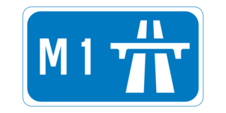
The M1 is a motorway in Northern Ireland. It is the longest motorway in Northern Ireland and runs for 38 miles (61 km) from Belfast to Dungannon through County Antrim, County Down, County Armagh and County Tyrone. It forms part of the route via the A1 in Northern Ireland between Belfast and Dublin as well as being a part of the unsigned European E01 and E18 routes.
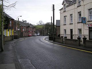
Milford or Millford is a small village about one mile southwest of Armagh in County Armagh, Northern Ireland. It is within the Armagh City and District Council area. It had a population of 569 people in the 2011 Census.

Cullyhanna is a small village and townland in County Armagh, Northern Ireland. The village extends further over the townlands of Tullynavall and Freeduff. It had a population of 306 in the 2001 Census. It is within the Newry and Mourne District Council area.
Cullybackey or Cullybacky is a large village in County Antrim, Northern Ireland. It lies 3 miles north-west of Ballymena, on the banks of the River Main, and is part of Mid and East Antrim district. It had a population of 2,569 people in the 2011 Census.

Killylea is a small village and townland in Northern Ireland. It is within the Armagh City and District Council area. The village is set on a hill, with St Mark's Church of Ireland, built in 1832, at its summit. The village lies to the west of County Armagh, and is close to the neighbouring counties of County Tyrone and County Monaghan which is in the Republic of Ireland. It had a population of 253 people in the 2011 Census.

Annahugh is a small village and townland near Loughgall in County Armagh, Northern Ireland. While most of the settlement is within the townland of Annahugh, part of it extends into the neighbouring townland of Ballyhagan. Hence, the two names are sometimes used to refer to the same settlement. It is situated within the Armagh City and District Council area. It had a population of 275 people in the 2011 Census.
Broomhill is a small village in County Armagh, Northern Ireland. It is within the townland of Drumnahunshin and the Armagh City and District Council area. It had a population of 197 people in the 2011 Census.
Edenaveys is a small village and townland in County Armagh, Northern Ireland. It lies southeast of Armagh and is within the Armagh City and District Council area. Historically, it has been anglicized as Edenafeagh amongst other variations. It had a population of 190 people in the 2011 Census.

The A4 is a major east–west road in Northern Ireland. It travels for 69.2 miles from Portadown to Belcoo through County Armagh, County Tyrone and County Fermanagh.
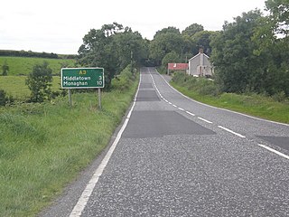
The A3 is a major road in Northern Ireland. It travels through County Antrim, County Down, County Armagh and parts of southern County Fermanagh.

Mullaghbawn, or Mullaghbane, is a small village and townland near Slieve Gullion in County Armagh, Northern Ireland. In the 2011 Census it had a population of 596.
Derrymore is a small village and townland in County Antrim, Northern Ireland. In the 2001 Census it had a population of 243 people. It lies on the shores of Lough Neagh, within the Armagh City, Banbridge and Craigavon Borough Council area.

European route E1 is a series of roads in Europe, part of the United Nations International E-road network, running from Larne, Northern Ireland to Seville, Spain. There is a sea crossing between Rosslare Harbour, in Ireland, and Ferrol, but no ferry service. The road also passes through Portugal – past the city of Porto, through the capital, Lisbon, and then south to the Algarve, passing Faro before reaching the Spanish border west of Huelva.

Annaghmore is a small village and townland near Loughgall in County Armagh, Northern Ireland. It is situated in the civil parish of Loughgall and the historic barony of Oneilland West. It had a population of 265 people in the 2011 Census.


