Milford or Millford is a small village about one mile southwest of Armagh in County Armagh, Northern Ireland. It is within the Armagh City and District Council area. It had a population of 569 people in the 2011 Census.

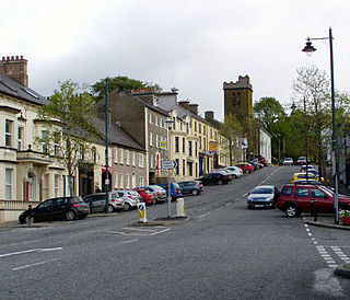
Keady is a village and civil parish in County Armagh, Northern Ireland. It is south of Armagh and near the border with the Republic of Ireland. It is situated mainly in the historic barony of Armagh with six townlands in the barony of Tiranny. It had a population of 3,051 people in the 2011 Census.

Loughgall is a small village, townland and civil parish in County Armagh, Northern Ireland. It is in the historic baronies of Armagh and Oneilland West. It had a population of 282 people in the 2011 Census. Loughgall was named after a small nearby loch. The village is surrounded by orchards.

Laurelvale is a village in County Armagh, Northern Ireland. It is beside the smaller village of Mullavilly and the two are sometimes referred to as Laurelvale-Mullavilly or Mullavilly-Laurelvale. The village is three miles south of Portadown and 1.5 miles northwest of Tandragee. It had a population of 1,288 people in the 2011 census.
Richhill is a large village and townland in County Armagh, Northern Ireland. It lies between Armagh and Portadown. It had a population of 2,738 people in the 2021 Census.

Annahugh is a small village and townland near Loughgall in County Armagh, Northern Ireland. While most of the settlement is within the townland of Annahugh, part of it extends into the neighbouring townland of Ballyhagan. Hence, the two names are sometimes used to refer to the same settlement. It is situated within the Armagh City and District Council area. It had a population of 275 people in the 2011 Census.

Ardress is a hamlet and townland between Loughgall and Annaghmore in County Armagh, Northern Ireland. It is made up of Ardress East and Ardress West. It is within the civil parish of Loughgall and barony of Oneilland West. It had a population of 90 people in the 2011 Census.
Broomhill is a small village in County Armagh, Northern Ireland. It is within the townland of Drumnahunshin and the Armagh City and District Council area. It had a population of 197 people in the 2011 Census.
Edenaveys is a small village and townland in County Armagh, Northern Ireland. It lies southeast of Armagh and is within the Armagh City and District Council area. Historically, it has been anglicized as Edenafeagh amongst other variations. It had a population of 190 people in the 2011 Census.

Kilmore or Killmore is a small village, townland and civil parish in County Armagh, Northern Ireland. It lies 2.5 miles (4 km) north of Richhill and within the Armagh City, Banbridge and Craigavon Borough Council area. It had a population of 190 people in the 2011 Census.

Lisnadill is a hamlet, townland and civil parish in County Armagh, Northern Ireland. In the 2001 Census it had a population of 54 people. It lies about 3 miles south of Armagh and is within the Armagh City, Banbridge and Craigavon Borough Council area.

Loughgilly is a small village, townland and civil parish in County Armagh, Northern Ireland. It is on the main Armagh to Newry road, about halfway between the two. It is within the Armagh City and District Council area. It had a population of 84 people in the 2011 Census.
Madden is a small village and townland in County Armagh, Northern Ireland. It is within the Armagh City, Banbridge and Craigavon Borough Council area. It has a population of around 200 people.
Mountnorris is a small village and townland in County Armagh, Northern Ireland. The village also extends into the townland of Tullyherron. It lies about six miles south of Markethill. It is within the Armagh, Banbridge and Craigavon local government area. It had a population of 155 people in the 2011 Census. Ulsterbus offers 1 stop in mountnorris. (2001 Census: 165 people

Mullaghbrack, Mullabrack or Mullaghbrac is a small civil parish, townland and village in County Armagh, Northern Ireland. The village of Mullaghbrack is on the road between Markethill and Hamiltonsbawn, just north of Gosford Forest Park. It had a population of 54 people in the 2011 census, down from 75 people as of the 2001 census.

Lislea is a small village and townland near Slieve Gullion in County Armagh, Northern Ireland. It is within the civil parish of Killevy and the historic barony of Orior Upper. Today it is within the Newry, Mourne and Down District Council area. It borders the townlands of Ballard, Carricnagalliagh, Aghmakane, Duburren and Drumilly. In the 2001 Census it had a population of 84 people.

Whitecross is a small village in County Armagh, Northern Ireland. It lies within the civil parish of Ballymyre and the townland of Corlat. In the 2011 Census it had a recorded population of 352.

Killeen or Killean is a small village and townland in the civil parish of Killevy, County Armagh, Northern Ireland. It lies about four miles (6.5 km) south of Newry, near the border with County Louth in the Republic of Ireland.

Poyntzpass is a small village on the border between southern County Armagh and County Down in Northern Ireland. It is situated in the civil parish of Ballymore and the historic barony of Orior Lower within the Armagh City, Banbridge and Craigavon area. It had a population of 552 people in the 2011 census. It was a part of the South Armagh constituency and is now part of the Newry and Armagh constituency.

Annaghmore is a small village and townland near Loughgall in County Armagh, Northern Ireland. It is situated in the civil parish of Loughgall and the historic barony of Oneilland West. It had a population of 265 people in the 2011 Census.

