Lurgan is a town in County Armagh, Northern Ireland, near the southern shore of Lough Neagh and roughly 18 miles (29 km) southwest of Belfast. The town is linked to Belfast by both the M1 motorway and the Belfast–Dublin railway line. Lurgan had a population of about 28,634 at the 2021 UK census, and falls within the Armagh, Banbridge and Craigavon district. For certain purposes, Lurgan is treated as part of the "Craigavon Urban Area", along with neighbouring Craigavon and Portadown.
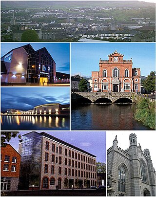
Newry is a city in Northern Ireland, standing on the Clanrye river in counties Down and Armagh. It is near the border with the Republic of Ireland, on the main route between Belfast and Dublin. The population was 27,913 in 2021.

Portadown is a town in County Armagh, Northern Ireland. The town sits on the River Bann in the north of the county, about 24 mi (39 km) southwest of Belfast. It is in the Armagh City, Banbridge and Craigavon Borough Council area and had a population of about 32,000 at the 2021 Census. For some purposes, Portadown is treated as part of the "Craigavon Urban Area", alongside Craigavon and Lurgan.

Craigavon is a town in northern County Armagh, Northern Ireland. Its construction began in 1965 and it was named after the first Prime Minister of Northern Ireland: James Craig, 1st Viscount Craigavon. It was intended to be the heart of a new linear city incorporating Lurgan and Portadown, but this plan was mostly abandoned and later described as having been flawed. Among local people today, "Craigavon" refers to the area between the two towns. It is built beside a pair of artificial lakes and is made up of a large residential area (Brownlow), a second smaller one (Mandeville), plus a central area (Highfield) that includes a substantial shopping centre, a courthouse and the district council headquarters. The area around the lakes is a public park and wildlife haven made up of woodland with walking trails. There is also a watersports centre, golf course and ski slope in the area. In most of Craigavon, motor vehicles are completely separated from pedestrians, and roundabouts are used extensively. It hosted the headquarters of the former Craigavon Borough Council.

Armagh is the county town of County Armagh and a city in Northern Ireland, as well as a civil parish. It is the ecclesiastical capital of Ireland – the seat of the Archbishops of Armagh, the Primates of All Ireland for both the Roman Catholic Church and the Church of Ireland. In ancient times, nearby Navan Fort was a pagan ceremonial site and one of the great royal capitals of Gaelic Ireland. Today, Armagh is home to two cathedrals and the Armagh Observatory, and is known for its Georgian architecture.
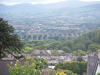
Bessbrook is a village in County Armagh, Northern Ireland. It lies about three miles (5 km) northwest of Newry and near the Newry bypass on the main A1 Belfast-Dublin road and Belfast-Dublin railway line. Today the village of Bessbrook straddles the three townlands of Maghernahely, Clogharevan and Maytown. Bessbrook is near Newry railway station. It had a population of 2,892 at the 2021 Census. The model village of Bessbrook, County Armagh is a visible memorial to the commercial endeavours of the Richardson family over a number of generations.

Tandragee is a town in County Armagh, Northern Ireland. It is built on a hillside overlooking the Cusher River, in the civil parish of Ballymore and the historic barony of Orior Lower.
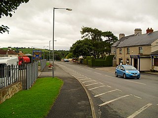
Milford or Millford is a small village about one mile southwest of Armagh in County Armagh, Northern Ireland. It is within the Armagh City and District Council area. It had a population of 569 people in the 2011 Census.
Bleary is a small village and townland in County Down, Northern Ireland. It is near the County Armagh border and the settlements of Craigavon, Lurgan and Portadown. In the 2011 Census its population was counted as part of Craigavon. It lies within the Armagh City, Banbridge and Craigavon area.

Keady is a village and civil parish in County Armagh, Northern Ireland. It is south of Armagh and near the border with the Republic of Ireland. It is situated mainly in the historic barony of Armagh with six townlands in the barony of Tiranny. It had a population of 3,051 people in the 2011 Census.
Hamiltonsbawn or Hamilton's Bawn is a village in County Armagh, Northern Ireland, five miles (8 km) east of Armagh. It lies within the Parish of Mullabrack and the Armagh, Banbridge and Craigavon District Council area. It had a population of 895 people in the 2011 Census.

Markethill is a village in County Armagh, Northern Ireland. It is beside Gosford Forest Park. It had a population of 1,647 people in the 2011 census.

Newtownhamilton is a small village and civil parish in County Armagh, Northern Ireland. It lies predominantly within Tullyvallan townland. The civil parish is within the historic barony of Fews Upper. In the 2011 Census it had 2,836 inhabitants.
Richhill is a large village and townland in County Armagh, Northern Ireland. It lies between Armagh and Portadown. It had a population of 2,738 people in the 2021 Census.

Killylea is a small village and townland in Northern Ireland. It is within the Armagh City and District Council area. The village is set on a hill, with St Mark's Church of Ireland, built in 1832, at its summit. The village lies to the west of County Armagh, and is close to the neighbouring counties of County Tyrone and County Monaghan which is in the Republic of Ireland. It had a population of 253 people in the 2011 Census.
Mountnorris is a small village and townland in County Armagh, Northern Ireland. The village also extends into the townland of Tullyherron. It lies about six miles south of Markethill. It is within the Armagh, Banbridge and Craigavon local government area. It had a population of 155 people in the 2011 Census. Ulsterbus offers 1 stop in mountnorris. (2001 Census: 165 people
The Birches is a small village in northern County Armagh, Northern Ireland. It is 6 miles northwest of Portadown, close to junction 12 on the M1 Motorway and to the southern shore of Lough Neagh. In the 2001 Census it had a population of 150. It is within the Armagh City, Banbridge and Craigavon council area.

Belleeks is a small village and townland in south County Armagh, Northern Ireland. In the 2011 Census it had a reported population of 375. It lies within the Newry, Mourne and Down District Council area and the historic barony of Upper Fews.

Banbridge is a town in County Down, Northern Ireland. It lies on the River Bann and the A1 road and is named after a bridge built over the River Bann in 1712. It is situated in the civil parish of Seapatrick and the historic barony of Iveagh Upper, Upper Half. The town began as a coaching stop on the road from Belfast to Dublin and thrived from Irish linen manufacturing. The town was home to the headquarters of the former Banbridge District Council. Following a reform of local government in Northern Ireland in 2015, Banbridge became part of Armagh City, Banbridge and Craigavon Borough Council. It had a population of 17,400 in the 2021 census.

Poyntzpass is a small village on the border between southern County Armagh and County Down in Northern Ireland. It is situated in the civil parish of Ballymore and the historic barony of Orior Lower within the Armagh City, Banbridge and Craigavon area. It had a population of 552 people in the 2011 census. It was a part of the South Armagh constituency and is now part of the Newry and Armagh constituency.

