
Aughanduff is a small village and townland in the civil parish of Forkhill, in the former barony of Orior Upper, and County of Armagh, Northern Ireland. The townland is roughly co-existent with Upper and Lower Aughanduff Mountains, both of which form part of the Ring of Gullion geological formation, which has been described as the most spectacular example of a ring-dyke intrusion in Ireland or Britain, and was the first ring dyke in the world to be geologically mapped. Aughanduff has been populated since prehistoric times and has been recorded as a distinct district since at least the early 1600s. The area's history is both well documented and reflects its location both in rural Ireland and on the borderlands of the Pale, the Plantation of Ulster, and latterly Northern Ireland; indeed, part of the district's northern boundary was proposed for forming part of the northern border of the Irish Free State by the Irish Boundary Commission in its final report of 1925. The Boundary Commission's report was never implemented and today, the area remains within Northern Ireland, some five miles from the border with the Republic of Ireland. Part of the area has been designated by the Northern Ireland Environment Agency as an Area of Special Scientific Interest, and the district lies within the Ring of Gullion Area of Outstanding Natural Beauty.
Massereene Upper is a barony in southwest County Antrim, Northern Ireland. It roughly matches the former district of Killultagh. It includes settlements such as Crumlin, Glenavy, Lower Ballinderry, Maghaberry and Aghalee. To its east lies Belfast Lough, and it is bordered by four other baronies: Massereene Lower to the north; Belfast Upper to the east; Castlereagh Upper to the south-east; and Iveagh Lower, Lower Half to the south-west.

Dungannon Middle is a barony in County Tyrone, Northern Ireland. It was created in 1851 with the splitting of the barony of Dungannon. It is bordered by Lough Neagh to the east and six other baronies: Dungannon Upper to the north; Oneilland West to the south-east; Armagh and Tiranny to the south; Dungannon Lower to the south-west; and Omagh East to the west.

Armagh is a barony in County Armagh, Northern Ireland. It lies in the west of the county, bordering County Tyrone with its north-western boundary, and bordering the Republic of Ireland with its southern boundary. It is bordered by five other baronies in Northern Ireland: Tiranny to the west, Dungannon Middle to the north-west, Oneilland West to the north-east, Fews Lower to the east, and Fews Upper to the south-east. It also borders to the south the barony of Cremorne in the Republic of Ireland.

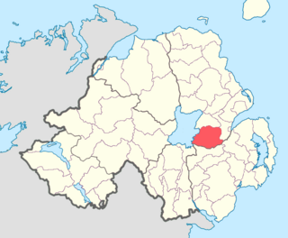
Oneilland West is a barony in County Armagh, Northern Ireland. It is also called Clancann, after the Mac Cana clan. It lies in the north of the county on the south-western shore of Lough Neagh and the border of County Tyrone. Oneilland West is bordered by five other baronies: Armagh to the west; Dungannon Middle to the north-west; Oneilland East to the north-east; Orior Lower to the south-east; and Kinelarty to the south.
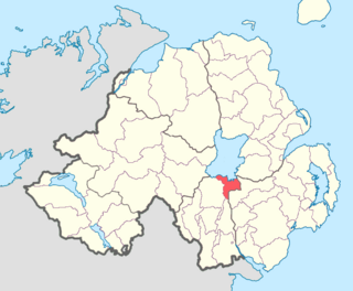
Oneilland East is a barony in the north-east of County Armagh, Northern Ireland. It is also called Clanbrasil. It lies in the north-east corner of the county, on the south-eastern shore of Lough Neagh and the boundary with County Down. Oneilland East is bordered by three other baronies: Oneilland West to the west; Iveagh Lower to the east; and Orior Lower to the south.

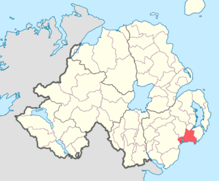
Orior Lower is a barony in County Armagh, Northern Ireland. It lies in the east of the county and borders County Down with its eastern boundary. It is bordered by seven other baronies: Fews Upper to the south-west; Fews Lower to the west; Oneilland West to the north-west; Oneilland East to the north; Iveagh Lower, Lower Half to the north-east; Iveagh Upper, Upper Half to the east; and Orior Upper to the south. A small enclave of Orior Lower resides in the east of Orior Upper.

Fews Upper is a barony in County Armagh, Northern Ireland. It lies in the south of the county bordering the Republic of Ireland with its southern and south-western borders. It is bordered by four other baronies in Northern Ireland: Armagh to the west; Fews Lower to the north and west; Orior Lower to the north-west; and Orior Upper to the east. It also borders three baronies in the Republic of Ireland: Cremorne to the west; Dundalk Upper to the south; and Farney to the south-west. Fews Lower and Upper formed the barony of The Fews until it was sub-divided.
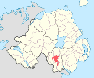
Fews Lower is a barony in County Armagh, Northern Ireland. Its lies in the center of the county, with an enclave lying just to the south-east. The main portion is bordered by four other baronies: Armagh to the west; Oneilland West to the north; Orior Lower to the east; and Fews Upper to the south. Fews Upper and Orior Lower also border the enclave to its north and west, with Orior Upper to its south-west. The Fews Mountains run through both Fews Lower and Upper, the highest peak of which in Fews Lower is, Deadman's Hill, which stands at 1,178 ft. Fews Lower and Upper formed the barony of The Fews until it was sub-divided.
Lecale Upper is a barony in County Down, Northern Ireland. To its south lies the Irish Sea, and it is bordered by three other baronies; Lecale Lower and Kinelarty to the north; and Iveagh Upper, Lower Half to the west.

Kinelarty is a former Irish district and barony in County Down, Northern Ireland. It lies east of the centre of the county, and is bordered by five other baronies: Iveagh Upper, Lower Half to the west; Lecale Upper to the south and south-east; Lecale Lower to the east; Castlereagh Upper to the north; and Iveagh Lower, Upper Half to the north-west.

Iveagh Upper, Lower Half is the name of a barony in County Down, Northern Ireland. It was created by 1851 with the division of the barony of Iveagh Upper into two. It lies in the centre of the county, and is bordered by six other baronies: Iveagh Upper, Upper Half and Lordship of Newry to the west; Mourne to the south; Kinelarty and Lecale Upper to the east; and Iveagh Lower, Upper Half to the north.

Iveagh Upper, Upper Half is the name of a barony in County Down, Northern Ireland. It was created by 1851 with the division of the barony of Iveagh Upper into two. It lies to the west and south of the county, split in half by the Lordship of Newry. It is bordered by six other baronies: Mourne to the south; Iveagh Upper, Lower Half to the east; Iveagh Lower, Lower Half and Iveagh Lower, Upper Half to the north; and Orior Lower and Orior Upper to the west.

Iveagh Lower, Upper Half is the name of a barony in County Down, Northern Ireland. It was created by 1851 with the division of the barony of Iveagh Lower into two. It is bordered by five other baronies: Iveagh Upper, Lower Half to the south; Iveagh Upper, Upper Half to the south-west; Iveagh Lower, Lower Half to the west and north; Castlereagh Upper to the north-east; and Kinelarty to the west.

Iveagh Lower, Lower Half is the name of a barony in County Down, Northern Ireland. It was created by 1851 with the division of the barony of Iveagh Lower into two. It is bordered by six other baronies: Massereene Upper to the north; Castlereagh Upper to the east; Iveagh Lower, Upper Half and Iveagh Upper, Upper Half to the south; Oneilland East and Orior Lower to the west.

Castlereagh Upper is a historic barony in County Down, Northern Ireland. It was created by 1841 with the division of Castlereagh into two. It is bordered by eight other baronies: Castlereagh Lower and Dufferin to the east; Lecale Lower and Kinelarty to the south; Iveagh Lower, Lower Half, Iveagh Lower, Upper Half, and Massereene Upper to the west; and Belfast Upper to the north.
Lordship of Newry is a historic barony in County Down, Northern Ireland.
Newry is a civil parish in County Armagh and County Down, Northern Ireland. It is situated in the historic baronies of Iveagh Upper, Lower Half and Lordship of Newry in County Down and the baronies of Orior Upper and Oneilland West in County Armagh.

Dundalk Lower is a barony in County Louth, Ireland.

