Forth or FORTH may refer to:

County Carlow is a county located in the Southern Region of Ireland, within the province of Leinster. Carlow is the second smallest and the third least populous of Ireland's 32 traditional counties. Carlow County Council is the governing local authority.
Úgaine Mór, son of Eochu Buadach, son of Dui Ladrach, was, according to medieval Irish legend and historical tradition, the 66th High King of Ireland.
The Castlecomer Plateau, or 'South Leinster Coalfield', is an upland area in the North of County Kilkenny, Ireland, extending into County Laois and County Carlow at its northern edge. The plateau is bounded on the east and south by the R448 regional road, on the west by the N77. The River Nore flows southward past the plateau's western flank, the River Barrow past its eastern flank and it is dissected by the River Dinin, which flows through Castlecomer itself.

Aghade is a civil parish and townland, in the barony of Forth in County Carlow, Ireland. It is 3 miles from Tullow and has a notable bridge over the River Slaney. It also has a church, and at one time had a school.

Galmoy is a barony in the north western part of County Kilkenny, Ireland. It is one of 12 baronies in County Kilkenny. The size of the barony is 162.7 square kilometres (62.8 sq mi). There are 12 civil parishes in Galmoy. While it is named after the village of Galmoy, today the chief town of the barony is Urlingford. Galmoy barony lies at the north-western corner of the county between Fassadinin to the east, and Crannagh to the south. It is surrounded on two sides by counties Tipperary to the west and Laois to the north. The M8 Dublin/Cork motorway bisects the barony. It is situated 121 kilometres (75 mi) from Dublin city and 131 kilometres (81 mi) from Cork city. Galmoy is currently administered by Kilkenny County Council. The barony was part of in the historic kingdom of Osraige (Ossory).

Belfast Upper is a barony in County Antrim, Northern Ireland. To its east lies the barony of Belfast and Belfast Lough, and it is bordered by five other baronies: Belfast Lower to the north-east; Antrim Upper to the north-west; Massereene Lower to the west; Massereene Upper to the south-west; and Castlereagh Upper to the south. The Forth River flows through both Belfast Upper and Lower. The most prominent hills in the barony are Black Hill and Lyle's Hill.
Clanawley is a barony in County Fermanagh, Northern Ireland. To its east lies Upper Lough Erne, and it is bordered by three other baronies: Magheraboy to the north; Tirkennedy and Knockninny to the east. It also borders three baronies in the Republic of Ireland: Tullyhaw to the south; and Drumahaire and Rosclogher to the west.

Fews Upper is a barony in County Armagh, Northern Ireland. It lies in the south of the county bordering the Republic of Ireland with its southern and south-western borders. It is bordered by four other baronies in Northern Ireland: Armagh to the west; Fews Lower to the north and west; Orior Lower to the north-west; and Orior Upper to the east. It also borders three baronies in the Republic of Ireland: Cremorne to the west; Dundalk Upper to the south; and Farney to the south-west. Fews Lower and Upper formed the barony of The Fews until it was sub-divided.
Fews Lower is a barony in County Armagh, Northern Ireland. Its lies in the center of the county, with an enclave lying just to the south-east. The main portion is bordered by four other baronies: Armagh to the west; Oneilland West to the north; Orior Lower to the east; and Fews Upper to the south. Fews Upper and Orior Lower also border the enclave to its north and west, with Orior Upper to its south-west. The Fews Mountains run through both Fews Lower and Upper, the highest peak of which in Fews Lower is, Deadman's Hill, which stands at 1,178 ft. Fews Lower and Upper formed the barony of The Fews until it was sub-divided.
The Fothairt were a Medieval Irish people based in Leinster.

Ardattin is a village and townland in County Carlow, Ireland, 6 km south of Tullow. It lies in the civil parish of Ardoyne in the historical barony of Forth. As of the 2011 census, the townland had a population of 34 people.

Carlow is a barony in County Carlow, Ireland.
Idrone East is a barony in County Carlow, Ireland. The early barony of Idrone was split into East and West in 1799.

Idrone West is a barony in County Carlow, Ireland. The early barony of Idrone was split into East and West in 1799.

Rathvilly is a barony in County Carlow, Ireland.

St. Mullin's Lower is a barony in County Carlow, Ireland.

St. Mullin's Upper is a barony in County Carlow, Ireland.
Gowran is a barony in the east of County Kilkenny, Ireland. The size of the barony is 430.5 square kilometres (166.2 sq mi). There are 35 civil parishes in Gowran. The chief town today is Gowran. The barony contains the ecclesiastical sites of Kilfane and Duiske Abbey The barony of Gowran is situated in the east of the county between the baronies of Fassadinin to the north, the baronies of Kilkenny, Shillelogher and Knocktopher to the west, and the barony of Ida is to the south. It borders County Carlow to the east. The M9 motorway bisects the barony.
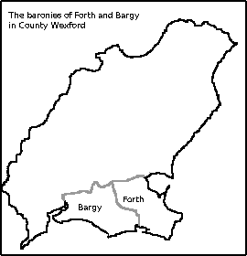
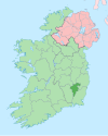
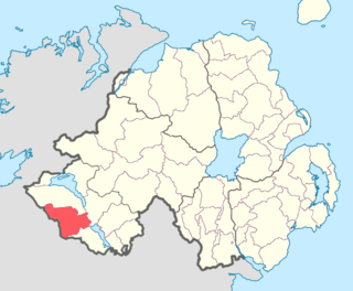
Forth is a barony in County Wexford in Ireland.