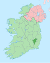
County Carlow is a county located in the Southern Region of Ireland, within the province of Leinster. Carlow is the second smallest and the third least populous of Ireland's 32 traditional counties. Carlow County Council is the governing local authority.

Enniscrone – also spelt Inniscrone and officially named Inishcrone – is a small seaside town in County Sligo, Ireland. Its sandy beach, tourist campsite, and golf course all attract visitors. As of the 2016 census, the town had a population of 1,156 people.

Graiguenamanagh or Graignamanagh is a town on the River Barrow in County Kilkenny, Ireland. Part of the settlement, known as Tinnahinch, is on the County Carlow side of the river, and Carlow County Council refers to the whole village as "Graiguenamanagh-Tinnahinch". Also combined for census purposes, as of the 2016 census, Graiguenamanagh-Tinnahinch had a population of 1,475 people.

Clonegal, officially Clonegall, is a village in the southeast of County Carlow, Ireland. It is in a rural setting, close to the border between counties Wexford and Carlow, 5 km from Bunclody, County Wexford and 22 km from Carlow town. It is just over a mile north of where the River Slaney and the River Derry meet. Clonegal has a much smaller "twin" village across the River Derry in County Wexford, Watch House Village.

Moone is a small village in the south of County Kildare, Ireland. It is on the former N9 road about 80 km (50 mi) south of Dublin. It has only a few hundred inhabitants, a church, a national school, one shop and a small community centre. There is also pub called the Moone High Cross Inn.

Stradone is a village located in County Cavan, Ireland. It is situated in the civil parish of Laragh six miles from Cavan, near the N3 road between Cavan and Virginia. Stradone is classified as a 'small village' in the Cavan County Council Development Plan 2014-2020.

Quigley's Point is a village in County Donegal, Ireland. Located on the eastern shores of Inishowen and overlooking Lough Foyle, the village is sometimes known locally as "Carrowkeel" as it is in a townland of that name. To the south is the city of Derry and to the north lie the villages of Moville and Greencastle. A car ferry links Greencastle with Magilligan during the summer. The river Cabry, which flows through the area, is spanned by a late-18th century bridge at Quigley's Point.
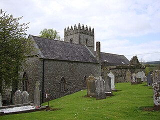
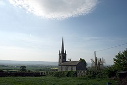
Old Leighlin is a small village in County Carlow, Ireland, 3.5 km west of Leighlinbridge. The site was at one time one of the foremost monastic houses in Leinster, with 1500 monks in residence. It was the location for a church synod in AD 630, which decided that the Irish church should follow Roman as opposed to Celtic dating conventions for determining the date of Easter.

Dundrum is a village in County Tipperary, Ireland. In the 2016 census, the population was 165. It is in the barony of Kilnamanagh Lower.

Nurney is a village in County Kildare, Ireland, on the Tully Stream.

Goresbridge is a small village located in the east of County Kilkenny, in the province of Leinster, Ireland. Goresbridge is named after a 1756 bridge, built by Colonel Ralph Gore, which provides a crossing of the River Barrow between County Kilkenny and County Carlow in the South-East region.
Ballyhide is a rural townland and village in the extreme south eastern corner of County Laois, Ireland at the border with County Carlow. The nearest urban centre is Carlow town which is 3 kilometres to the north east. It is located in the Luggacurren Local Electoral District.

Galmoy is a barony in the north western part of County Kilkenny, Ireland. It is one of 12 baronies in County Kilkenny. The size of the barony is 162.7 square kilometres (62.8 sq mi). There are 12 civil parishes in Galmoy. While it is named after the village of Galmoy, today the chief town of the barony is Urlingford. Galmoy barony lies at the north-western corner of the county between Fassadinin to the east, and Crannagh to the south. It is surrounded on two sides by counties Tipperary to the west and Laois to the north. The M8 Dublin/Cork motorway bisects the barony. It is situated 121 kilometres (75 mi) from Dublin city and 131 kilometres (81 mi) from Cork city. Galmoy is currently administered by Kilkenny County Council. The barony was part of in the historic kingdom of Osraige (Ossory).

Clogh is a village, and namesake of an electoral district in County Kilkenny, Ireland. It is also a townland in the civil parish of Castlecomer in the ancient barony of Fassadinin.

Ardattin is a village and townland in County Carlow, Ireland. It lies in the civil parish of Ardoyne in the historical barony of Forth. As of the 2011 census, the townland had a population of 34 people.

Nurney Cross is a stone cross located in Nurney, County Carlow, Ireland, and is an early example of a high cross.
Aughnacliffe, officially Aghnacliff , is a village in County Longford, Ireland. It is located close to Lough Gowna and the border with County Cavan.

Ballinabranna or Ballinabrannagh is a small village in County Carlow, Ireland. It is located approximately 8 kilometres south of Carlow and 5 kilometres from Junction 6 of the M9 motorway. It is within the townland of Ballinabrannagh, and is in the barony of Idrone West. As of the 2016 census, the population of the village was 466.

Castlejordan is a village and townland in County Meath, Ireland. It is located in the south of the county, close to the border with County Offaly, to the south of Kinnegad. The townland of Castlejordan has an area of approximately 2.2 square kilometres (0.85 sq mi), and had a population of 85 people as of the 2011 census.

Rathtoe, also spelled Rathoe, is a village and townland in County Carlow, Ireland. The village is located in the civil parish of Gilbertstown, between Tullow and Ballon, County Carlow. The Burren River flows through the area. Rathtoe is a census town, and had a population of 304 as of the 2016 census.