County Wicklow is a county in Ireland. The last of the traditional 32 counties to be formed, as late as 1606, it is part of the Mid-East Region and is also located in the province of Leinster. It is named after the town of Wicklow, which derives from the Old Norse name Víkingaló, which means "Vikings' Meadow". Wicklow County Council is the local authority for the county. The population of the county was 142,425 at the 2016 census.

County Wexford is an eastern county in Ireland, bordered by the Irish Sea. It is in the province of Leinster and is part of the South-East Region. It is named after the town of Wexford and was based on the historic Gaelic territory of Hy Kinsella, whose capital was Ferns. Wexford County Council is the local authority for the county. The population of the county was 149,722 at the 2016 census.

Kildare is a town in County Kildare, Ireland. As of 2016, its population was 8,634 making it the 7th largest town in County Kildare. The town lies on the R445, some 50 km (31 mi) west of Dublin – near enough for it to have become, despite being a regional centre in its own right, a commuter town for the capital. Although Kildare gives its name to the county, Naas is the county town.

These are lists of mountains and mountain ranges in Ireland. Those within Northern Ireland, or on the border, are marked with an asterisk, while the rest are within the Republic of Ireland. Where mountains are ranked by height, the definition of the "topographical prominence", used to classify the mountain, is noted. In British definitions, a height of 600 metres (1,969 ft) is required for a "mountain", whereas in Ireland, a lower threshold of 500 metres (1,640 ft) is sometimes advocated.

The Carlow County Board of the Gaelic Athletic Association (GAA) or Carlow GAA is one of the 32 county boards of the GAA in Ireland, and is responsible for Gaelic games in County Carlow and the Carlow inter-county teams.
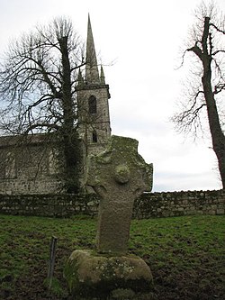
Old Leighlin is a small town in County Carlow, Ireland, 3.5 km west of Leighlinbridge. The site was at one time one of the foremost monastic houses in Leinster, with 1500 monks in residence. It was the location for a church synod in AD 630, which decided that the Irish church should follow Roman as opposed to Celtic dating conventions for determining the date of Easter.

Killeshin is a village in County Laois, Ireland on the R430 regional road. Killeshin is a small rural community situated five kilometres west of Carlow town and overlooks the picturesque Barrow Valley. The church at the foot of the Killeshin hills is the site of an early Christian monastery.

Carlow is the county town of County Carlow, in the south-east of Ireland, 84 km (52 mi) from Dublin. At the 2016 census, it had a combined urban and rural population of 24,272.
Nurney is a village in County Kildare, Ireland, on the Tully Stream.
The Blackstairs Mountains run roughly north/south along the border between County Carlow and County Wexford in Ireland. The highest peak is Mount Leinster with a total height of 2612 ft/ 796 metres.

Carlow–Kilkenny is a parliamentary constituency represented in Dáil Éireann, the lower house of the Irish parliament or Oireachtas. The constituency elects 5 deputies. The method of election is the single transferable vote form of proportional representation (PR-STV).
The High Sheriff of Carlow was the British Crown's judicial representative in County Carlow, Ireland from the 14th century until 1922, when the office was abolished in the new Free State and replaced by the office of Carlow County Sheriff. The sheriff had judicial, electoral, ceremonial and administrative functions and executed High Court Writs. In 1908, an Order in Council made the Lord-Lieutenant the Sovereign's prime representative in a county and reduced the High Sheriff's precedence. However the sheriff retained his responsibilities for the preservation of law and order in the county. The usual procedure for appointing the sheriff from 1660 onwards was that three persons were nominated at the beginning of each year from the county and the Lord Lieutenant then appointed his choice as High Sheriff for the remainder of the year. Often the other nominees were appointed as under-sheriffs. Sometimes a sheriff did not fulfil his entire term through death or other event and another sheriff was then appointed for the remainder of the year. The dates given hereunder are the dates of appointment. All addresses are in County Carlow unless stated otherwise.
Idrone East is a barony in County Carlow, Republic of Ireland. The early barony of Idrone was split into East and West in 1799.
Castlemore Moat is a motte-and-bailey and National Monument in County Carlow, Ireland.

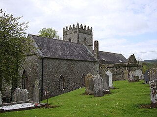
Sleaty Church is a medieval church and National Monument located in County Laois, Ireland.

Ullard Church is a medieval church and National Monument in County Kilkenny, Ireland.