Clonlisk

Last updated

Clonlisk
Cluain Leisc (Irish)
Baronies of Offaly.jpg
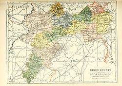
Baronies of County Offaly. Clonlisk is shaded green.
Ireland relief location map.png
Red pog.svg
Clonlisk
Coordinates: 52°57′24.77″N7°55′17.76″W / 52.9568806°N 7.9216000°W / 52.9568806; -7.9216000
Sovereign state Ireland
County Offaly
Area
  Total198.51 km2 (76.64 sq mi)
Clonlisk

Clonlisk (Irish : Cluain Leisc) is a barony in County Offaly (formerly King's County), Ireland.

Contents

Etymology

Clonlisk derives its name from Clonlisk Castle (near Dunkerrin) and the townland of Clonlisk (Irish Cluain Leisc, 'meadow of laziness'). [1]

Location

Clonlisk is located in southwest County Offaly.

History

Clonlisk was part of the territory of the Ó Cearbhaill (O'Carroll) of Éile (Ely). [2]

List of settlements

Below is a list of settlements in Clonlisk:

Related Research Articles

<span class="mw-page-title-main">Leinster</span> Traditional province in the east of Ireland

Leinster is one of the four provinces of Ireland, situated in the southeast and east of Ireland.

<span class="mw-page-title-main">Clonmacnoise</span> Ruined monastery in County Offaly, Ireland

Clonmacnoise is a ruined monastery situated in County Offaly in Ireland on the River Shannon south of Athlone, founded in 544 by Saint Ciarán, a young man from Rathcroghan, County Roscommon. Until the 9th century it had close associations with the kings of Connacht.

The kingdom of Uí Fháilghe, Uí Failge or Uíbh Fhailí was a Gaelic-Irish kingdom which existed to 1550, the name of which is preserved in the name of County Offaly, Ireland.

Birr, a division of King's County, was a constituency in Ireland, returning one Member of Parliament to the United Kingdom House of Commons from 1885 to 1918.

<span class="mw-page-title-main">Twelve Apostles of Ireland</span> Irish monastic saints in 6th century

The Twelve Apostles of Ireland were twelve early Irish monastic saints of the sixth century who studied under St Finnian at his famous monastic school Clonard Abbey at Cluain-Eraird, now Clonard in County Meath.

<span class="mw-page-title-main">Shinrone</span> Village in County Offaly, Ireland

Shinrone is a village in County Offaly, Ireland. It is in the southernmost part of the county, close to the border with County Tipperary. It lies at the junction of the R491 regional road between Nenagh and Roscrea with the R492 to Sharavogue. At the 2016 census, the village population was 645.

<span class="mw-page-title-main">Tiranny</span> Place in Northern Ireland, United Kingdom

Tiranny is a barony in County Armagh, Northern Ireland. It lies on the western boundary of the county, bordering County Tyrone to its west and County Monaghan in the Republic of Ireland to its south. It is bordered by three other baronies in Northern Ireland: Dungannon Lower and Dungannon Upper to the north-west; and Armagh to the east. It also borders two baronies in the Republic of Ireland; Cremorne to the south and Trough to the west.

<span class="mw-page-title-main">Clonygowan</span> Village in Leinster, Ireland

Clonygowan is a village in County Offaly, Ireland, on the R420 regional road between Tullamore to Portarlington road. As of the 2016 census, it had a population of 198 people. The main village centre is built around a central green.

<span class="mw-page-title-main">Theobald Walter, 1st Chief Butler of Ireland</span> 12th-century Anglo-Norman nobleman in Ireland

Theobald Walter was the first Chief Butler of Ireland. He also held the office of Chief Butler of England and was the High Sheriff of Lancashire for 1194. Theobald was the first to use the surname Butler of the Butler family of Ireland. He was involved in the Irish campaigns of King Henry II of England and John of England. His eldest brother Hubert Walter became the Archbishop of Canterbury and justiciar and Lord Chancellor of England.

<span class="mw-page-title-main">Clondrohid</span> Village in County Cork, Ireland

Clondrohid is a village and civil parish in County Cork, Ireland, four miles (6 km) north of Macroom. As of the 2016 census, the population of the village was recorded as 179, down from 188 people as of the 2011 census.

<span class="mw-page-title-main">Cloonanaha</span> Village in County Clare, Ireland

Cloonanaha is a small village and townland in County Clare, Ireland.

Éile, commonly anglicised as Ely, was a medieval petty kingdom in the southern part of the modern county of Offaly and parts of North Tipperary in Ireland. The historic barony of Eliogarty was once a significant portion of the kingdom.

Edmund Butler, 6th Chief Butler of Ireland and nominally Earl of Carrick, was an Irish magnate who served as Justiciar of Ireland during the difficult times of the Scottish invasion from 1315 to 1318 and the great famine of 1316 to 1317.

Cloncollow is a townland in the Parish of Tomregan, Barony of Loughtee Lower, County Cavan, Ireland.

Sharavogue is a townland in the historical Barony of Clonlisk, County Offaly, Ireland. It is a rural area located near the junction of the N52 road and the R492 between Roscrea and Birr. The Little Brosna River flows under Sharavogue bridge.

<span class="mw-page-title-main">St Gobhan</span>

Saint Gobhan has long been linked with the parish of Seagoe – recorded for instance as Teach dho-Ghobha – in County Armagh, Ireland.

Clonloghan is a civil parish of County Clare, Ireland, located 21.7 kilometres (13.5 mi) by road northwest of Limerick, just north of Shannon.

<span class="mw-page-title-main">Clonlonan</span> Barony in Leinster, Ireland

Clonlonan is a barony in south–west County Westmeath, Ireland. It was formed by 1672. It is bordered by County Offaly to the south and a small part of County Roscommon at Long Island on the River Shannon to the west. It also borders four other Westmeath baronies: Kilkenny West and Rathconrath, Moycashel and Brawny. The largest centre of population in the barony is the town of Moate.

Kilcumreragh is a civil parish which spans the counties of Westmeath and Offaly in Ireland. It is located about 23.23 kilometres (14 mi) west–south–west of Mullingar and 18.28 kilometres (11 mi) north–north–west of Tullamore.

Leitrim is a barony in Ireland that lies partly in County Galway and partly in County Clare. It is located in the south-eastern corner of County Galway and the north-eastern corner of County Clare. Prior to 1898, the entire barony was contained in County Galway. The Local Government (Ireland) Act 1898 split the barony: part of the barony was transferred to County Clare. Leitrim is bounded, clockwise from the southwest, by the Clare baronies of Tulla Upper and Tulla Lower; the Galway baronies of Loughrea to the west, Kilconnell to the north, and Longford to the east; and by Lough Derg to the south and southeast. It measures 20 miles (32 km) from north to south and 9.5 miles (15.3 km) from east to west.

References