Related Research Articles

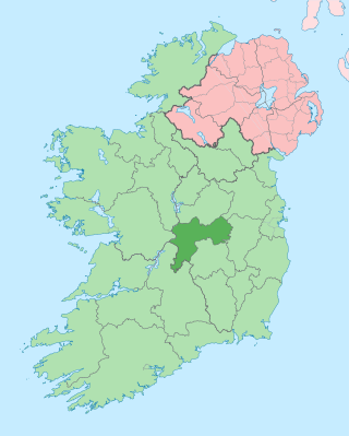
County Offaly is a county in Ireland. It is part of the Eastern and Midland Region and the province of Leinster. It is named after the ancient Kingdom of Uí Failghe. It was formerly known as King's County, in honour of Philip II of Spain. Offaly County Council is the local authority for the county. The county population was 82,668 at the 2022 census.
Bord na Móna is a semi-state company in Ireland, created in 1946 by the Turf Development Act 1946. The company began developing the peatlands of Ireland with the aim to provide economic benefit for Irish Midland communities and achieve security of energy supply for the recently formed Irish Republic. The development of peatlands involved the mechanised harvesting of peat, which took place primarily in the Midlands of Ireland.

The Bog of Allen is a large raised bog in the centre of Ireland between the rivers Liffey and Shannon.

Shannonbridge is a village located on the River Shannon, at the junction of the R444 and R357 regional roads in County Offaly, Ireland. It lies within the townland of Raghra, at the borders of counties Offaly, Galway and Roscommon, with the majority of the population living east of the bridge in County Offaly. As of the 2016 census, the village had a population of 175. There are two housing estates within the village. Its location along Ireland's largest river and its proximity to Clonmacnoise have contributed to tourism being a key contributor to the local economy. The village is flanked by a Special Area of Conservation – the Shannon Callows. The physical environment consists of the River Shannon, callows, boglands and the Esker Riada. The village has one of the oldest bridges still in use over the River Shannon, completed in 1757.

Kilcormac is a small town in County Offaly, Ireland, located on the N52 at its junction with the R437 regional road, between the towns of Tullamore and Birr. It is a small town of 935 people, many of whom were previously employed by Bord na Móna to work the local peat bogs. The town is located near the Slieve Bloom Mountains. The Silver River flows through the town. The town was more commonly referred to as Frankford prior to Irish independence.
Ballynahone Bog is a raised bog, situated in County Londonderry, Northern Ireland, about 3 km south of Maghera, on low-lying ground immediately north of the Moyola River about 14 km from its mouth at Lough Neagh. It is one of the largest lowland raised bogs in Northern Ireland.

Pollagh, also spelled Pullough, is a village in County Offaly, Ireland, located in the midlands of Ireland. It is a rural village on the Grand Canal and lies between Ferbane and Tullamore. Much of the surrounding area is bogland, and is used to produce fossil fuels such as peat turf. The River Brosna flows close to the village. The Grand Canal was used for transporting peat and bricks produced in the area. Pollagh benefited from the canal in earlier years when it brought investment and employment from Bord na Móna, and it is now a tourist attraction. Pollagh is also known for its church, including its bog oak altar and stained glass windows, designed by the Harry Clarke studios.

Rhode is a village in County Offaly, Ireland. It is situated on the R400 at its junction with the R441 which leads to Edenderry, 12 km to the east. Rhode village is on an "island" of high ground surrounded by an expanse of raised bog which forms part of the Bog of Allen.

Clara Bog is one of the largest relatively intact raised bogs remaining in Ireland. It lies southeast of the R436 regional road between the village of Ballycumber and the town of Clara, in County Offaly. Much of the bog is state-owned and managed as a nature reserve covering some 460 ha. A Special Area of Conservation covers 836 ha.

The Clonmacnoise and West Offaly Railway was a former tourist attraction based on a narrow-gauge industrial railway in the Midlands of Ireland.

Boora Bog is a cutaway peat bog situated in County Offaly, Ireland. Peat was harvested for fuel between the 1950s and 1970s, and the land is now being reclaimed for agricultural and eco-tourism use. There was a lake called Lough Boora, which was drained by Bord na Móna, but was not used for peat production: this area is now maintained as a nature reserve by the Irish Wildlife Trust. There are two angling lakes.

Lullymore is a civil parish in County Kildare in Ireland. It is in the historical barony of Offaly East. The lowest observed 20th century air temperature in Ireland, -18.8 °C was measured at Lullymore on 2 January 1979.

Bargerveen Nature Reserve is a nature reserve in the Dutch province of Drenthe that has been included in the Natura 2000 ecological network. Since 2006 it is part of the Internationaler Naturpark Bourtanger Moor-Bargerveen, a nature reserve located on both sides of the border between the Netherlands and Germany. Most of the transboundary nature reserve, some 134 km2 (52 sq mi), lies in Germany, in the west of the state of Lower Saxony. The sparsely populated landscape consists of large peat areas, heather, and small lakes.

The Offaly Way is a long-distance trail in County Offaly, Ireland. It is 37 kilometres long and begins in Cadamstown and ends at Lemanaghan, on the R436 road between the towns of Clara and Ferbane. It is typically completed in two days. It is designated as a National Waymarked Trail by the National Trails Office of the Irish Sports Council and is managed by Offaly County Council, Bord na Mona and the Offaly Integrated Development Company. The trail provides a link between the Slieve Bloom Way and the Grand Canal Way.
Redwood is a townland in the historical Barony of Ormond Lower, County Tipperary, Ireland. It is also an electoral district in the Dáil constituency of Offaly having previously been part of the Tipperary North Dáil constituency.

Mongan Bog is a peat bog in County Offaly, Ireland. The bog is located east of Clonmacnoise, a monastic site on the river Shannon. A nature reserve covering about 120 ha protects part of the bog.
Easkey Bog is a blanket bog, national nature reserve, and Ramsar site of approximately 1,500 acres (6.1 km2) in County Sligo.
Redwood Bog is a raised bog and national nature reserve of approximately 326 acres (1.32 km2) in County Tipperary.
The Derrinlough briquette factory is a production facility in County Offaly, Ireland, opened in 1957 and planned for closure in June 2023.
References
- ↑ "Raheenmore Bog". Ramsar Sites Information Service. Retrieved 25 April 2018.
- ↑ "Bord na Móna". Archived from the original on 19 November 2007. Retrieved 17 July 2010.
- ↑ "Bord na Móna and Bog Conservation".
- ↑ "Ramsar Sites Database". Archived from the original on 20 March 2012. Retrieved 3 July 2011.
- ↑ "Archived copy" (PDF). Archived from the original (PDF) on 26 March 2012. Retrieved 30 June 2011.
{{cite web}}: CS1 maint: archived copy as title (link) - ↑ Taoiseach's speech: 7 March 2011, www.taoiseach.gov.ie