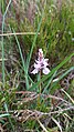
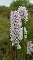
Peat, also known as turf, is an accumulation of partially decayed vegetation or organic matter. It is unique to natural areas called peatlands, bogs, mires, moors, or muskegs. The peatland ecosystem covers 3.7 million square kilometres (1.4 million square miles) and is the most efficient carbon sink on the planet, because peatland plants capture carbon dioxide (CO2) naturally released from the peat, maintaining an equilibrium. In natural peatlands, the "annual rate of biomass production is greater than the rate of decomposition", but it takes "thousands of years for peatlands to develop the deposits of 1.5 to 2.3 m [4.9 to 7.5 ft], which is the average depth of the boreal [northern] peatlands", which store around 415 gigatonnes (Gt) of carbon (about 46 times 2019 global CO2 emissions). Globally, peat stores up to 550 Gt of carbon, 42% of all soil carbon, which exceeds the carbon stored in all other vegetation types, including the world's forests, although it covers just 3% of the land's surface. Sphagnum moss, also called peat moss, is one of the most common components in peat, although many other plants can contribute. The biological features of sphagnum mosses act to create a habitat aiding peat formation, a phenomenon termed 'habitat manipulation'. Soils consisting primarily of peat are known as histosols. Peat forms in wetland conditions, where flooding or stagnant water obstructs the flow of oxygen from the atmosphere, slowing the rate of decomposition. Peat properties such as organic matter content and saturated hydraulic conductivity can exhibit high spatial heterogeneity.

County Offaly is a county in Ireland. It is part of the Eastern and Midland Region and the province of Leinster. It is named after the ancient Kingdom of Uí Failghe. It was formerly known as King's County, in honour of Philip II of Spain. Offaly County Council is the local authority for the county. The county population was 77,961 at the 2016 census.
Bord na Móna, is a semi-state company in Ireland, created in 1946 by the Turf Development Act 1946. The company began developing the peatlands of Ireland with the aim to provide economic benefit for Irish Midland communities and achieve security of energy supply for the recently formed Irish Republic. The development of peatlands involved the mechanised harvesting of peat, which took place primarily in the Midlands of Ireland.

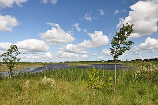
Mer Bleue Bog is a 33.43 km2 (12.91 sq mi) protected area east of Ottawa in Eastern Ontario, Canada. Its main feature is a sphagnum bog that is situated in an ancient channel of the Ottawa River and is a remarkable boreal-like ecosystem normally not found this far south. Stunted black spruce, tamarack, bog rosemary, blueberry, and cottongrass are some of the unusual species that have adapted to the acidic waters of the bog.

Burns Bog is an ombrotrophic peat bog located in Delta, British Columbia, Canada. It is the largest raised peat bog and the largest undeveloped urban land mass on the West Coast of the Americas. Burns Bog was originally 4,000–4,900 hectares before development. Currently, only 3,500 hectares remain of the bog.

Fenn's, Whixall and Bettisfield Mosses National Nature Reserve is a national nature reserve (NNR) which straddles the border between England and Wales, near Whixall and Ellesmere in Shropshire, England and Bettisfield in Wrexham County Borough, Wales. It comprises three peat bogs, Bettisfield Moss, Fenn's Moss and Whixall Moss. With Wem Moss and Cadney Moss, they are collectively a Site of Special Scientific Interest called The Fenn's, Whixall, Bettisfield, Wem & Cadney Moss Complex and form Britain's third-largest lowland raised bog, covering 2,388 acres (966 ha). The reserve is part of the Midland Meres and Mosses, an Important Plant Area which was declared a Wetland of International Importance under the Ramsar Convention in 1997. It is also a European Special Area of Conservation.
Ballynahone Bog is a raised bog, situated in County Londonderry, Northern Ireland, about 3 km south of Maghera, on low-lying ground immediately north of the Moyola River about 14 km from its mouth at Lough Neagh. It is one of the largest lowland raised bogs in Northern Ireland.

Westhay Moor is a 513.7-hectare (1,269-acre) biological Site of Special Scientific Interest 2.5 kilometres (1.6 mi) north-east of Westhay village and 4 kilometres (2.5 mi) from Wedmore in Somerset, England, notified in 1971. Westhay Moor is also notified as part of the Somerset Levels and Moors Special Protection Area under the EU Birds Directive and as a Ramsar site, and a National Nature Reserve.
The Curraghs or Ballaugh Curraghs are a wetland in Ballaugh parish in the north-west of the Isle of Man. The area has a rich and varied biodiversity and is also the location of the Curraghs Wildlife Park, a zoo and nature reserve that incorporates the wetlands.

Pollagh, also spelled Pullough, is a village in County Offaly, Ireland, located in the midlands of Ireland. It is a rural village on the Grand Canal and lies between Ferbane and Tullamore. Much of the surrounding area is bogland, and is used to produce fossil fuels such as peat turf. The River Brosna flows close to the village. The Grand Canal was used for transporting peat and bricks produced in the area. Pollagh benefited from the canal in earlier years when it brought investment and employment from Bord na Móna, and it is now a tourist attraction. Pollagh is also known for its church, including its bog oak altar and stained glass windows, designed by the Harry Clarke studios.

Cors Caron is a raised bog in Ceredigion, Wales. Cors is the Welsh word for "bog". Cors Caron covers an area of approximately 349 hectares. Cors Caron represents the most intact surviving example of a raised bog landscape in the United Kingdom. About 44 different species groups inhabit the area including various land and aquatic plants, fish, insects, crustaceans, lichen, fungi, terrestrial mammals and birds.

Dersingham Bog is a 159.1-hectare (393-acre) biological and geological Site of Special Scientific Interest in Norfolk, England. It is a Nature Conservation Review site, Grade 2, a National Nature Reserve and a Ramsar site It is part of the Norfolk Coast Area of Outstanding Natural Beauty, and the Roydon Common & Dersingham Bog Special Area of Conservation Part of it is a Geological Conservation Review site.
Boora Bog is a cutaway peat bog situated in County Offaly, Ireland. Peat was harvested for fuel between the 1950s and 1970s, and the land is now being reclaimed for agricultural and eco-tourism use. There was a lake called Lough Boora, which was drained by Bord na Móna, but was not used for peat production: this area is now maintained as a nature reserve by the Irish Wildlife Trust. There are two angling lakes.

Ham Wall is an English wetland National Nature Reserve (NNR) 4 kilometres (2.5 mi) west of Glastonbury on the Somerset Levels. It is managed by the Royal Society for the Protection of Birds (RSPB). Since the last Ice Age, decomposing plants in the marshes of the Brue valley in Somerset have accumulated as deep layers of peat that were commercially exploited on a large scale in the twentieth century. Consumer demand eventually declined, and in 1994 the landowners, Fisons, gave their old workings to what is now Natural England, who passed the management of the 260 hectares Ham Wall section to the RSPB.

Bargerveen Nature Reserve is a nature reserve in the Dutch province of Drenthe that has been included in the Natura 2000 ecological network. Since 2006 it is part of the Internationaler Naturpark Bourtanger Moor-Bargerveen, a nature reserve located on both sides of the border between the Netherlands and Germany. Most of the transboundary nature reserve, some 134 km2 (52 sq mi), lies in Germany, in the west of the state of Lower Saxony. The sparsely populated landscape consists of large peat areas, heather, and small lakes.
Raheenmore Bog is a raised bog north-west of Daingean, County Offaly, in Ireland. Since the 1980s the greater part of the bog has been maintained as a 162 hectare Nature Reserve, which is currently managed by the National Parks and Wildlife Service. A Special Area of Conservation covers 182 ha, including some land in private ownership.
Mongan Bog is a peat bog in County Offaly, Ireland. The bog is located east of Clonmacnoise, a monastic site on the river Shannon. A nature reserve covering about 120 ha protects part of the bog.

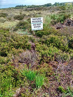
Moine Mhòr encompasses a large area of raised bog in the Kilmartin Glen area of Argyll and Bute, Scotland. As well as raised bog there are areas of saltmarsh, brackish grassland, alder carr, fen and woodland, and the variety of habitats at Moine Mhòr provide important habitats for a variety of animal and plant species. The area was declared a national nature reserve (NNR) in 1987, and is now owned and managed by NatureScot. According to NatureScot lowland raised bogs like Moine Mhòr are some of the rarest and most threatened natural wildlife habitats in Europe, due to removal of peat, afforestation and reclamation of farmland.

Pollardstown Fen is Ireland's largest extant calcareous spring-fed fen, a national nature reserve, Special Area of Conservation, and Ramsar site of approximately 321 acres (1.30 km2) in County Kildare.