Related Research Articles

County Offaly is a county in Ireland. It is part of the Eastern and Midland Region and the province of Leinster. It is named after the ancient Kingdom of Uí Failghe. It was formerly known as King's County, in honour of Philip II of Spain. Offaly County Council is the local authority for the county. The county population was 77,961 at the 2016 census.

Birr is a town in County Offaly, Ireland. Between 1620 and 1899 it was called Parsonstown, after the Parsons family who were local landowners and hereditary Earls of Rosse. Birr is a designated Irish Heritage Town with a carefully preserved Georgian heritage. Birr itself has graceful wide streets and elegant buildings. Many of the houses in John's Place and Oxmantown Mall have exquisite fanlight windows of the Georgian period. The town is known for Birr Castle and gardens, home of the Parsons family, and also site of the Leviathan of Parsonstown, the largest telescope in the world for over 70 years, and a large modern radio telescope.

Birr Castle is a large castle in the town of Birr in County Offaly, Ireland. It is the home of the 7th Earl of Rosse and his family, and as such the residential areas of the castle are not open to the public, though the grounds and gardens of the demesne are publicly accessible, and include a science museum and a café, a reflecting telescope which was the largest in the world for decades and a modern radio telescope.

The River Brosna is a river within the Shannon River Basin in Ireland, flowing through County Westmeath and County Offaly.
Meelick MILIC is a townland on the River Shannon in Ireland. It lies approximately 4 km southeast of Eyrecourt in County Galway.It is best known for its walkway that connects to Lusmagh (Offaly). It also holds the oldest church still in use in Ireland at a staggering 607 years old given papal permission and built in 1414AD it is also within the Parish of Clonfert which is home to the madona statue OUR LADY OF CLONFERT Clonfert is the head of its diocese with its headquarters home to Most REV.Bishop Michael Duignan St.Brendans Presbytery Loughrea. It is home to the oldest hurling club in Ireland which was founded in 1884. It has a little pub 10 yards from The Church known locally as “George’s/The Shop” It holds a kayaking festival each year after the boating season halts to its winter end with a great quay half way between Portumna and Banagher home to SilverLine Cruisers, CarrickCraft and Emerald Star-line. It holds a car rally in association with Galway Rally ever few years. Its current Parish Priest (2021) is REV.Fr.Declan McInerney PP.

Riverstown is a small village straddling the border between Counties Tipperary and Offaly on the outskirts of Birr in Ireland. It is mostly within the townland of Ballyloughnane, on the Tipperary side of the river.

Brosna is a small village and townland in County Offaly, Ireland. It lies in the valley of the Little Brosna River less than one kilometer off the N62 national secondary road. As of the 2011 census, Brosna townland had a population of 31 people. The area takes its named from the Little Brosna River, which flows through the townland.
Rathcabbin often Rathcabban is a small village and an electoral district situated at the very north of County Tipperary in Ireland. The village is located off the R489 regional road between Portumna, County Galway and Birr, County Offaly. It is 5 km east of the River Shannon and Lough Derg.
Raheenmore Bog is a raised bog north-west of Daingean, County Offaly, in Ireland. Since the 1980s the greater part of the bog has been maintained as a 162 hectare Nature Reserve, which is currently managed by the National Parks and Wildlife Service. A Special Area of Conservation covers 182 ha, including some land in private ownership.

The Little Brosna River rises near Dunkerrin, County Offaly, Ireland. It flows for 36 miles before joining the River Shannon.
The Ballyfinboy River rises close to Moneygall in County Offaly, Ireland and flows in a generally northwesterly direction into Lough Derg at Drominagh. It forms part of the boundary between County Tipperary and County Offaly. The river flows through the towns of Cloughjordan and Borrisokane west of which it flows past Ballyfinboy Castle, a ruined tower house with a Sheela na gig in the townland of Ballyfinboy.
Derrinsallow is a townland in the historical Barony of Ormond Lower, County Tipperary, Ireland. It is located North-West of Birr on the south-west bank of the Little Brosna River within the civil parish of Dorrha. The Little Brosna River provided power to the 19th century corn mills at Derrinsallow which although now in ruins are mentioned in the National Inventory of Architectural Heritage. The mill race is a popular fishing area. A triple arched limestone bridge from the 19th century crosses the river here.
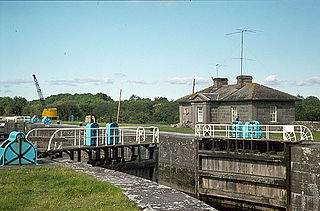
Victoria Lock, also known as Meelick Lock, is the first lock on the River Shannon upstream of Lough Derg, it is situated between Meelick, County Galway and Clonahenoge, County Offaly where the Little Brosna River enters the Shannon. It is very near the tripoint where the provinces of Munster, Leinster and Connacht meet. The lock is of architectural and technical interest and is listed on the Nation Inventory of Architectural Heritage, the dimensions are 142 ft x 40 ft. Thomas Rhodes on the instructions of the Shannon Commissioners constructed the lock in the 1840s as part of a widescale upgrade of the Shannon Navigation. The lock is still in use today by pleasure craft, both private and fleets of rental cruisers who use the River Shannon and the connecting canals. A second lock, Hamilton Lock is also located nearby but is now disused.

The R492 is a regional road in County Offaly linking Shinrone to the N62 at Sharavogue between Roscrea and Birr. The road is approximately 6 km (3.7 mi) long.
Sharavogue is a townland in the historical Barony of Clonlisk, County Offaly, Ireland. It is a rural area located around the junction of the N52 road and the R492 between Roscrea and Birr. The Little Brosna River flows under Sharavogue bridge.
The 2013 Offaly Senior Hurling Championship was the 115th staging of the Offaly Senior Hurling Championship since its establishment in 1896. The championship began on 10 May 2013 and ended on 6 October 2013.
The 2014 Offaly Senior Hurling Championship was the 116th staging of the Offaly Senior Hurling Championship since its establishment by the Offaly Cound Board in 1896. The championship began on 2 May 2014 and ended on 19 October 2014.

The Shannon River Basin consists of the area containing Ireland's longest river, the River Shannon, and all of its tributaries and lakes. The official Ordnance Survey Ireland length of the Shannon from its Shannon Pot source is 224 miles (360 km) made up of 63.5 miles (102.2 km) tidal water flow and 160.5 miles (258.3 km) freshwater flow.
The 2012 Offaly Senior Hurling Championship was the 114th staging of the Offaly Senior Hurling Championship since its establishment by the Offaly County Board in 1896. The draw for the 2012 fixtures took place on 28 January 2012. The championship began on 11 May 2012 and ended on 7 October 2012.
The Figile River is a river in eastern Ireland.
References
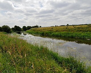
| Wikimedia Commons has media related to River Camcor . |
- ↑ Champ, W. S. T. (1983), "Quantification of trout stocks in an alkaline river fishery", Irish Fisheries Investigations, A (23): 47–51
- ↑ County Offaly: State of the Wild 2007: page 70 Offaly County Council, 2007. ISBN 978-1-905254-21-7.
- ↑ "Archived copy" (PDF). Archived from the original (PDF) on 25 April 2012. Retrieved 18 February 2014.
{{cite web}}: CS1 maint: archived copy as title (link)
Coordinates: 53°5′29″N7°54′48″W / 53.09139°N 7.91333°W
| | This article related to the geography of County Offaly, Ireland is a stub. You can help Wikipedia by expanding it. |