
Dún Laoghaire–Rathdown is a county in Ireland. It is in the province of Leinster and the Eastern and Midland Region. It is one of three successor counties to County Dublin, which was disestablished in 1994. It is named after the former borough of Dún Laoghaire and the barony of Rathdown. Dún Laoghaire–Rathdown County Council is the local authority for the county. The population of the county was 233,860 at the time of the 2022 census.

The River Dodder is one of the three main rivers in Dublin, Ireland, the others being the Liffey, of which the Dodder is the largest tributary, and the Tolka.

Enniskerry is a village in County Wicklow, Ireland. The population was 2,008 at the 2022 census.

Santry River is a small watercourse on the north side of Dublin city, one of the forty or so watercourses monitored by Dublin City Council. It runs, mostly unculverted, from Harristown and Dubber near Dublin Airport, through Santry and Coolock, reaching the sea at Raheny, in a lagoon area inshore of Bull Island.

The Naniken River is a minor river on the north side of Dublin city, Ireland, one of more than forty watercourses monitored by Dublin City Council. It is culverted for its upper course, visible in St Anne's Park for its entire lower course, and causes flooding somewhere along its line most years. The river flows entirely within the jurisdiction of Dublin City Council.

The R117 road is a regional road in Ireland. The route (north-south) starts Harcourt Road at the end of the South Circular Road on the southside of Dublin city centre. It crosses the Grand Canal and goes through the suburbs of Ranelagh, Milltown, Windy Arbour, Dundrum, Sandyford, Stepaside and Kilternan before passing through the Scalp into County Wicklow.

Carrickmines is an outer suburb of Dublin in Dún Laoghaire–Rathdown, Ireland. The area, still semi-rural, was historically on the border of English control and featured a defensive construction, Carrickmines Castle, which became the subject of national controversy during the building of a late stage of Dublin's M50 orbital motorway.

Two Rock is a mountain in Dún Laoghaire–Rathdown, Ireland. It is 536 metres high and is the 382nd highest mountain in Ireland. It is the highest point of the group of hills in the Dublin Mountains which comprises Two Rock, Three Rock, Kilmashogue and Tibradden Mountains. The mountain takes its name from the two granite tors that lie to the south-east of the summit. From the summit, which is called Fairy Castle, there are views of much of the Dublin area from Tallaght to Howth to the north while Bray Head, Killiney Hill, the Great Sugar Loaf and the Wicklow Mountains are visible to the south. The summit area is mostly shallow bog while ferns and gorse cover the lower slopes. The mountain is also an important habitat for red grouse.

The R112 road is a regional road in south Dublin, Ireland. It begins at the junction with the R148 road at Chapelizod and arcs southeastwards, then eastwards across the middle of south Dublin, ending at the Mount Merrion junction of the R138. The road is a single-carriageway, with cycle lanes on some stretches. Improvements to the road have been made over the last 10 years, the most significant being at Dundrum Cross where the road was widened to make room for the new Luas bridge and Dundrum bypass.

The Dublin Mountains Way is a waymarked long-distance trail in the Dublin Mountains, Counties South Dublin and Dún Laoghaire–Rathdown, Ireland. The route is approximately 42 kilometres long and runs from Shankill in the east to Tallaght in the west. It has been developed by the Dublin Mountains Partnership, an umbrella group of relevant state agencies and recreational users working to improve recreational facilities in the Dublin Mountains.

Carrickgollogan is a hill in Dún Laoghaire–Rathdown in Ireland, towards the southern border of the traditional County Dublin. It is 276 metres high, on the eastern edge of the Dublin Mountains, rising above the districts of Rathmichael and Shankill. Its summit is noted for the panoramic views it offers of south Dublin and north Wicklow.

Barnaslingan is a 238 metres high hill in County Dublin, Ireland. It is most noted for the geological feature known as The Scalp that lies to the west of the summit. Samuel Lewis, in A Topographical Dictionary of Ireland (1837), described it thus: “A deep natural chasm in the mountain, forming a defile with lofty and shelving ramparts on each side, from which large detached masses of granite many tons of weight have fallen, on each side large masses of detached rock are heaped together in wild confusion, apparently arrested in their descent, and threatening at every moment to crush the traveller by their fall”.

The River Slang, also known as the Dundrum Slang or the Dundrum River, a tributary of the River Dodder, is a stream which rises on Three Rock Mountain, County Dublin. It is in the local government area of Dún Laoghaire–Rathdown.
The Owendoher River is a small river in southern County Dublin, Ireland, the largest tributary of the River Dodder, and a part of the River Liffey system.
The Bradogue River is a small river in Dublin that rises in Cabra and flows into the River Liffey, with its primary outfall at Ormond Quay. It is culverted for its entire course.

The Broadmeadow River or Broad Meadow Water, is a river of County Meath and northern County Dublin, about 25 kilometres (16 mi) long. It opens into a wide estuary between Swords and Malahide, and reaches the open sea several kilometres downstream, north of Malahide village. One of the larger watercourses by volume in County Dublin, the Broadmeadow is a salmonid river, with several species of fish, including brown trout. It has many small, and a few larger, tributaries, notably the Ward River. It is under the responsibility of Meath County Council and Fingal County Council, as well as oversight of the Environmental Protection Agency.
The Ballyboghil River or Ballyboughal Water is a river in Fingal, in the traditional County Dublin, about 18 kilometres (11 mi) long, reaching the sea by way of the 4.5 kilometres (2.8 mi)-long estuary. One of the larger watercourses by volume in the north County Dublin, the Ballyboghil is a salmonid river, with several species of fish, including brown trout. It has many small tributaries, and one larger tributary system. It is under the responsibility of Fingal County Council, and the oversight of the Environmental Protection Agency.
The Mayne River, is a small watercourse of northern County Dublin. It forms from the merger of the Cuckoo and Turnapin Streams, which rise near Dublin Airport and help drain the airport campus. The river is in the jurisdiction of Fingal County Council and within the oversight of the Environmental Protection Agency.

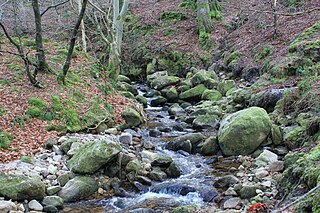
The Shanganagh River is the largest watercourse system in Dún Laoghaire–Rathdown. It has two main source lines, one from Three Rock Mountain, one with multiple sources between Three Rock and Foxrock, and its components pass through many suburbs of Dublin; it ultimately reaches the sea on Killiney Strand, in Shanganagh. The river is in the jurisdiction of Dún Laoghaire–Rathdown County Council, as well as within the purview of the Environmental Protection Agency.
