River Lee

Last updated

River Lee
The Gearagh 2.jpg
The Gearagh, a submerged woodland situated on the Lee near Macroom
River Lee Ireland Map.jpg
Map of the River Lee drainage basin
Native nameAn Laoi (Irish)
Physical characteristics
Source 
  location Shehy Mountains near Gougane Barra
Mouth  
  location
Celtic Sea at Cork Harbour mouth
Length90 km (56 mi) [1]
Basin size1,253.5 km2 (484.0 sq mi) [1]
Discharge 
  average40.4 m3/s (1,430 cu ft/s) [2]
Basin features
Tributaries 
  right Curraheen River

The River Lee (Irish : An Laoi [3] ) is a river in Ireland. It rises in the Shehy Mountains on the western border of County Cork and flows eastwards through Cork, where it splits in two for a short distance, creating an island on which Cork's city centre is built, then passing through Cork Harbour on the south coast, one of the largest natural harbours in the world, to empty into the Celtic Sea. The catchment area of the River Lee is 1,253 km2. [4] The long-term average flow rate of the River Lee is 40.4 cubic metres per second (m3/s) [4]

Contents

A hydro-electric scheme was built on the river, upstream from Cork City, and this part of the river now contains the Carrigadrohid and Inniscarra reservoirs. The river is crossed by 42 bridges, 29 of which are in Cork City, and one tunnel. The river also provides an 8 kilometres (5.0 mi) stretch of salmon fishing.[ citation needed ]

Name

Ptolemy's Geography (2nd century AD) described a river called Δαβρωνα (Dabrona) or Λαβρωνα (Labrona), which is sometimes considered to refer to the River Lee. [5] Though unconfirmed, [6] the Irish name for the river, Laoi, may derive from Corca Luighe, which in turn derives from 'Luighe', the son of a quasi-mythical Milesian noble. [7] [8]

There is also the Λουρ (Lour), a separate river which passes through Tralee. [5]

Description

Sources

The River Lee has its source in the Shehy Mountains near Gougane Barra, where there is a forest park, chapel, hotel, and shop.

Course

River Lee north channel River Lee at Cork.jpg
River Lee north channel

The Lee flows from the lake of Gougane Barra as a fast-paced torrent, but by the town of Ballingeary it eases and flows into Lough Allua. Departing the lough, running east, it again becomes a rapid flow before running into The Gearagh, and Carrigadrohid feeder reservoirs, and then into the large Inniscarra reservoir created by Inniscarra Dam. Moving on, it flows down from the dam, in normal conditions a gentle river until it comes to Ballincollig Weir in Ballincollig Park; here it is dangerous to swimmers when in high water. The Lee then flows into the city under Inniscarra Bridge and flows parallel to the Carrigrohane road. Along this section gauges monitor the water levels from the Inniscarra Dam. The river flows over the Lee weir and then is split into the north and south channels at a sluice (it historically occupied the city area as a maze of channels). This area is popular for recreation, kayaking and fishing. The two channels join again at the Cork docks and enter the extensive estuary and harbour, south of Glanmire, passing either side of Great Island (Cobh lies on the south coast) to fill the outer harbour, and reaching the open sea between Whitegate and Crosshaven.

Tributaries

Upper course (above Inchigeela)

High tributaries include the Owenagariff, the Bunsheelin, the Paudeen and the Garrifowa. [9]

Middle course (to the Dripsey)

Tributaries joining below Lough Allua and Inchigeela include the River Toon, the extensive Sullane River system, from near Ballyvourney (tributaries include the Douglas, Finnow, Foherish and Laney or Laine Rivers) via Macroom, the smaller Buinea and Glashagariff Rivers, and the River Dripsey and its tributaries the Rylane and the Delaghinagh. [9]

Near Cork city

Below the last ESB dam, tributaries joining include the River Bride from Slievowen via Crookstown, Killumney and Ovens, and the River Shournagh (formed from the Blarney and Martin Rivers, and the Owennagearagh River; historically may have been the Awbeg River). [9]

City area

River Lee south channel 2017-06-15 7356x4904 cork river lee south channel.jpg
River Lee south channel

City area tributaries include the combined Maglin (from Ballincollig) and Curraheen (occasionally Curragheen) Rivers, capturing the Glasheen River also and joining at the western end of the UCC complex, and the Kiln River (sometimes Bride River) which joins by the Christy Ring Bridge in the city centre, a little west of St. Patrick's Bridge [9] [10] (formed in turn from a Bride River and the Kilnap or Glennamought River, later joined by the Glen River).

Tidal area

Estuarine tributaries include the Glashaboy River, passing Glanmire (main tributaries the Black Brook, Cloghnageshee River and Butterstown River), [9] the Douglas or Tramore River (joined by the Trabeg River as it flows into the Douglas Channel, its estuary) which drains parts of the southern city, Owennacurra River (joined by the Dungurney River at Midleton), and the Owenaboy River almost at the final mouth of the outer Lee estuary (the Liberty Stream joins this river, with significant flows from Cork Airport). [11]

Recreation

Recreation activities on the Lee include sailing, swimming, kayaking, water skiing. Several rowing clubs are based on the Lee including the "Lee Rowing Club", "Shandon Boat Club" and “Cork Boat Club”. Naomhoga Chorcai is also based on the Marina, and is Ireland's largest Currach (traditional canvas fishing boat) rowing club.[ citation needed ] Angling is also common from the banks of the Lee Fields.[ citation needed ]

Flooding

In 2009, water was released in large quantities from the Inniscarra Dam, causing flood damage in Cork City Inniscarra dam.jpg
In 2009, water was released in large quantities from the Inniscarra Dam, causing flood damage in Cork City
Red Dragon sculpture in Lee Fields which are frequently flooded Red Dragon scuplture during River Lee flooding, October 2023.jpg
Red Dragon sculpture in Lee Fields which are frequently flooded

Tidal considerations, combined with low-lying urban developments, and later dam management contribute to repeated flooding events on the Lee. [12] [13] [14] [15] For example, specific streets in Cork city centre have been affected by floods more than 100 times since the mid-19th century. [16]

2009 flooding

In late 2009 the river flooded, causing some of the most significant damage in Cork city for a number of centuries. The Lee Water Station was forced to shut down after being submerged under six metres of water, and resulted in 40% of Cork City (50,000 people) being without running water for over a week. [17] Lower-lying parts of the University College Cork campus were also flooded extensively, resulting in lectures being cancelled throughout the week. [18] There was severe damage to the university's then newly built IT building, the Western Gateway Building, situated next to the river on a known floodplain, where, for example, a 300-seat auditorium was flooded to near ceiling height. [19] To prevent issues upstream, the ESB made a controversial decision to release water from the Inniscarra hydro-electric dam. This released 535 tonnes of water per second into the already flooded river, raising the flood to 1.5 metres in parts of the city centre. The ESB insisted this was an essential move, and if water had not been released, the flooding would have been much worse. [20]

See also

Related Research Articles

<span class="mw-page-title-main">County Cork</span> County in Ireland

County Cork is the largest and the southernmost county of Ireland, named after the city of Cork, the state's second-largest city. It is in the province of Munster and the Southern Region. Its largest market towns are Mallow, Macroom, Midleton, and Skibbereen. As of 2022, the county had a population of 584,156, making it the third-most populous county in Ireland. Cork County Council is the local authority for the county, while Cork City Council governs the city of Cork and its environs. Notable Corkonians include Michael Collins, Jack Lynch, Roy Keane, Sonia O'Sullivan, Cillian Murphy, and Graham Norton.

<span class="mw-page-title-main">River Shannon</span> Longest river in the British Isles

The River Shannon is the major river on the island of Ireland, and at 360 km in length, is the longest river in the British Isles. It drains the Shannon River Basin, which has an area of 16,900 km2 (6,525 sq mi), – approximately one fifth of the area of Ireland.

<span class="mw-page-title-main">Shannon hydroelectric scheme</span> Electricity generation project in County Clare, Ireland

The Shannon hydroelectric Scheme was a major development by the Irish Free State in the 1920s to harness the power of the River Shannon. Its product, the Ardnacrusha power plant, is a hydroelectric power station located near Ardnacrusha within County Clare approximately 2.4 kilometres (1.5 mi) from the Limerick border. It is Ireland's largest river hydroelectric scheme and is operated on a purpose built headrace connected to the River Shannon. The plant includes fish ladders so that returning fish, such as salmon, can climb the river safely past the power station.

<span class="mw-page-title-main">Ballincollig</span> Town in Cork city, Ireland

Ballincollig is a suburban town within the administrative area of Cork city in Ireland. It is located on the western side of Cork city, beside the River Lee on the R608 regional road. In 2016 it was the largest town in County Cork, at which time the Ballincollig Electoral Division had a population of 18,621 people. It is located beyond the green belt from the suburbs of Bishopstown and Wilton. Historically home to the Ballincollig Royal Gunpowder Mills which is now a Regional Park, the town has seen much growth in recent years as a satellite of Cork City. Ballincollig is within the Cork North-West Dáil constituency.

<span class="mw-page-title-main">Gougane Barra</span> Valley and heritage site in County Cork, Ireland

Gougane Barra is a scenic valley and heritage site in the Shehy Mountains of County Cork, Ireland. It is near Ballingeary in the Muskerry Gaeltacht. Gougane Barra is at the source of the River Lee and includes a lake with an oratory built on a small island. It also includes a forest park.

<span class="mw-page-title-main">Shehy Mountains</span>

The Shehy Mountains are a range of low mountains situated on the border between County Cork and County Kerry, in Ireland.

<span class="mw-page-title-main">Cork (city)</span> City in County Cork, Munster, Ireland

Cork is the second largest city in the Republic of Ireland, third largest on the island of Ireland, and largest in the province of Munster. At the 2022 census, it had a population of 222,526.

<span class="mw-page-title-main">Carrigrohane Straight</span> Segment of road in County Cork, Ireland

The Carrigrohane Straight is a straight segment of road that stretches for 2.75 miles (4.43 km), from the edge of Cork west to Carrigrohane in County Cork, Ireland. It is just over 140 years old, and now forms part of the N22 National Primary route between Cork and Tralee.

<span class="mw-page-title-main">Dripsey</span> Village in County Cork, Ireland

Dripsey is a village in County Cork on the R618 regional road around 20 km (12 mi) west of Cork City. It is situated on a tributary of the River Lee, the Dripsey River. It is in the Catholic parish of Inniscarra. The Dripsey area hosts a water treatment plant, the Cork offices of the Environmental Protection Agency, and an award-winning garden center. The village has one pub, a primary school and a pre-school.

Canovee is the name of a rural region and a village nucleus in the Lee valley in County Cork, Ireland. The toponym 'Canovee' is synonymous with the official version Cannaway, and the electoral division of Cannaway.

Muskerry GAA is a Gaelic football and hurling division located in the middle region of County Cork, Ireland. It is one of eight divisions of Cork GAA County Board. The division includes clubs from areas to the west of Cork city stretching to the county bounds with Kerry. Its name is derived from the ancient Gaelic kingdom of Múscraige which, following the Norman conquest, now encompasses the baronies of Muskerry West and Muskerry East. These baronies, or half-baronies, include towns such as Macroom, Ballincollig, and Ballingeary. Muskerry GAA is bordered by Carrigdhoun GAA and Carbery GAA divisions to the south and by Duhallow GAA to the north. It organizes competitions for the clubs within the division, from "Under 12" up to the adult level. The winners of these competitions compete against other divisional champions to determine which club is the county champion. In addition, the division selects football and hurling teams from the adult teams playing at junior level or county intermediate level; these then compete for the Cork Senior Football Championship and Cork Senior Hurling Championship.

<span class="mw-page-title-main">Inniscarra</span>

Inniscarra is a civil parish in the barony of Muskerry East, County Cork, Ireland. It is located about 15km west of Cork city. The local GAA club is Inniscarra GAA and Dripsey GAA. Inniscarra is located on the north side of the River Lee. Inniscarra Dam is one of the two Hydro-Electric Dams on the River Lee.

<span class="mw-page-title-main">Inniscarra Dam</span> Dam in County Cork

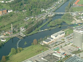
Inniscarra Dam is a buttress dam located on the River Lee in the civil parish of Inniscarra in County Cork, Ireland. Construction of the dam started in February 1953 and resulted in the formation of the Inniscarra Reservoir. The dam is owned and operated by the ESB Group and has a generation capacity of 19 MW. It over-flooded in November 2009 and caused around 100 million euros worth of damage to the city, with University College Cork saying it damaged 20 million euros worth of property.

<span class="mw-page-title-main">Inchigeelagh</span> Village in County Cork, Ireland

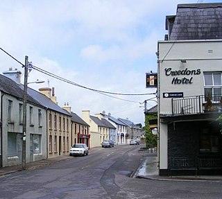
Inchigeelagh is a small village, townland and civil parish in County Cork, Ireland. The village is just outside a Gaeltacht area. Inchigeelagh is part of the Dáil constituency of Cork North-West.

<span class="mw-page-title-main">Lough Allua</span> Lake in County Cork, Ireland

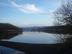
Lough Allua is a freshwater lake in County Cork with an area of 1.36 km² located beside Inchigeelagh and forms part of the River Lee.

<span class="mw-page-title-main">Inniscarra Lake</span> Reservoir in County Cork

Inniscarra Lake is located along the River Lee in County Cork, Ireland. It is a man-made reservoir formed in the 1950s when Inniscarra Dam was constructed by the Electricity Supply Board. Construction of the dam commenced in 1953, with its floodgates first closed in 1956 and the reservoir fully formed by late 1957.

<span class="mw-page-title-main">The Gearagh</span>

The Gearagh is a submerged glacial woodland and nature reserve two kilometres southwest of Macroom, County Cork, in Kilmichael parish, Ireland. It is located at the point where the River Lee descends from the mountains and widens at an alluvial plain, and stretches for roughly five kilometres, bounded by the townlands of Toonsbridge, Illaunmore and Anahala.

<span class="mw-page-title-main">R584 road (Ireland)</span> Road in Ireland

The R584 road is a regional road in Ireland. It is a road in west County Cork.

<span class="mw-page-title-main">Carrigadrohid hydroelectric power station</span> Dam in County Cork, Ireland

Carrigadrohid hydroelectric power station is a hydroelectric plant located on the River Lee in County Cork, Ireland. It is owned and operated by the ESB Group. The dam is 130 m (427 ft) long and has a single 8 MW (11,000 hp) Kaplan turbine which produces an average of 22 GWh (79 TJ) each year. Built between 1952 and 1957. the construction of Carrigadrohid required the destruction of over half of the Gearagh, an ancient alluvial forest, and initially harmed local wildlife. However, subsequently the area has seen the growth of an ecosystem with kingfishers, otters, salmon and swans, which has been designated European Union Special Area of Conservation.

The Curraheen River is a river in County Cork and Cork City, Ireland, a tributary of the River Lee.

References

  1. 1 2 "Irishfisheries.com/waterways - River Lee". irishfisheries.com. Archived from the original on 17 November 2007.
  2. "Archived copy" (PDF). Archived from the original (PDF) on 3 March 2016. Retrieved 2 March 2015.{{cite web}}: CS1 maint: archived copy as title (link)
  3. "An Laoi/River Lee". Logainm.ie. Irish Placenames Commission. Retrieved 17 December 2019.
  4. 1 2 South Eastern River Basin District Management System (PDF). South Eastern River Basin District Report (Report). p. 38. Archived from the original (PDF) on 3 March 2016.
  5. 1 2 "Ireland" (PDF). Romaneranames.uk. Roman Era Names. Retrieved 1 January 2018.
  6. Kieran McCarthy (2017). Secret Cork. Amberley Publishing. ISBN   9781445667157. The origin of the name Lee is sketchy and legend reputedly attributes the name to [..] the Milesians [..who..] named [the area] 'Corca Luighe' [..] The River Lee [..] has had many variations of spelling. In [..] the Book of Lismore, it is described as Luae. It has also been written as Lua, Lai, Laoi and the Latin Luvius
  7. "River Lee Project". CorkHeritage.ie. Retrieved 1 January 2018.
  8. John Windele (1910). Cork: Historical and Descriptive Notices of the City of Cork from Its Foundation to the Middle of the 19th Century. Guy and Company. p. 3.
  9. 1 2 3 4 5 Milner, Liam (1975). The River Lee and Its Tributaries (1 ed.). Cork, Ireland: Tower Books.
  10. "Insurance Plan of Cork (Goad Map)" (PDF). 1897 via corkpastandpresent.ie.
  11. Lee CFRAMS: Hydrology Report, Halcrow Group Ireland (Report). Cork: OPW. 2008.
  12. "Lee CFRAM Study Predictive Flood Maps". opw.ie. Office of Public Works.
  13. "Lee Catchment Flood Risk Assessment and Management Study". 8 May 2016. Archived from the original on 8 May 2016.{{cite web}}: CS1 maint: bot: original URL status unknown (link)
  14. Lee Catchment Flood Risk Assessment and Management Study - REP007 - Final Report (PDF). lee.cfram.com (Report). Halcrow Group Ireland. January 2014. Archived from the original (PDF) on 8 May 2016.
  15. "Lower Lee (Cork City) Flood Relief Scheme". lowerleefrs.ie. Archived from the original on 2 June 2016.
  16. "Flooding in Oliver Plunkett Street - Cork Past & Present". corkpastandpresent.ie. Cork City Libraries. Retrieved 17 December 2019.
  17. "City facing bill of €100m to fix flood damage". Irish Independent. 23 November 2009. Retrieved 27 January 2010. Independent.ie's summary on the flood
  18. "University College Cork (UCC): Weather Notifications". Archived from the original on 24 November 2009. Retrieved 27 January 2010. UCC's Notification webpage on the floods
  19. "Report-on-Major-Flood-Damage.pdf" (PDF). Retrieved 27 January 2010. PDF file on the damages
  20. Riegel, Ralph; Melia, Paul (8 December 2009). "ESB stands by decision to release water into city centre". Irish Independent. Archived from the original on 22 October 2012. Retrieved 27 January 2010.

51°53′55″N8°32′21″W / 51.89861°N 8.53917°W / 51.89861; -8.53917