![]() | This article may require cleanup to meet Wikipedia's quality standards. The specific problem is: Much of the content is mirrored from original sources (without much attempt at integration). Much of the content is laid-out using pseudo-headings (without consideration to related guidelines).(December 2020) |
Canovee | |
---|---|
Coordinates: 51°53′21″N8°51′19″W / 51.8892°N 8.8553°W | |
Country | Ireland |
Province | Munster |
County | County Cork |
Time zone | UTC+0 (WET) |
• Summer (DST) | UTC-1 (IST (WEST)) |
Canovee is the name of a rural region and a village nucleus in the Lee valley in County Cork, Ireland. The toponym 'Canovee' is synonymous with the official version Cannaway (as in the civil parish of Cannaway), [1] and the electoral division of Cannaway. [2]
"Island" of Canavoy
Canovee has sometimes been referred to as an 'island', [3] because most of the parish's boundaries are formed by bodies of water. For example, the River Lee constituting its north-eastern, northern and north-western borders, the Kame River and one of its tributaries lie to the east, and the Aghthying Stream is to the west.
Civil parish of Cannaway
The civil parish of Cannaway corresponds to the 'Island of Canavoy'. Civil parishes were ecclesiastical units of territory based on Gaelic tuatha, [4] or early Christian and monastic settlements from the 12th century. They were later adopted by the Church of Ireland, and subsequently became civil administrative areas.
The official names of the constituent townlands of the civil parish of Cannaway, as per the Placenames (County Cork) Order 2012 include: [5]
Mahallagh is translated as Maigh Shalach, even though it is mentioned in Mac Carthaigh's Book in the year 1262 as Magh Oiligh [6] ('Oiligh' being the genitive of 'Oileach', a word for stony, or a stone building- and 'Oileach' as spoken in Munster Irish matching local pronunciation of the name as closely as 'Shalach').
Electoral division of Cannaway
The electoral division of Cannaway, number 18201, includes the 16 townlands of the civil parish of Cannaway, as well as Rooves Beg (An Rú Beag), which is a constituent townland of the neighbouring civil parish of Aglish. [7] [5] [8]
As per the CSO, the population of the Cannaway Electoral Division (21.6km2) in 2011 was 595, with 293 males and 302 females. There was an increase of 13.8% since 2006. [9]
Mac Carthaigh's Book
Mac Carthaigh's Book (published in the 17th century) records that in 1262[sic], the Norman De Cogan castle of Magh Oiligh (Mahallagh) was destroyed by Fínghin Reanna Róin Mac Carthaigh, King of Desmond, and the people of Desmond. [6] Finghín's forces defeated the Norman FitzGeralds of Munster at the Battle of Callan in 1261, curtailing Geraldine influence in Desmond.
Annals Of Innisfallen
The Annals of Inisfallen record that, in 1317, "warfare breaks out between some of the Cogans and the Barrys, and the lands of Dáuíd de Cócán from Loch Mu-Choba to Bern na hEile are laid waste and burned by the Barrys and some of the Roches. After Candlemas a further prey is taken by them against the same Cogans; and in the course of this raid J[ohn ?], son of Godfrey, is despoiled, his court being burned, and the castle of Mag Oilig (Mahallagh) is destroyed" (once again). [10]
Civil Survey Of The Barony Of Muskerry (1656) [3]
The Civil Survey was a cadastral survey of landholdings in Ireland by the Cromwellian administration, showing proprietors and property as they stood at the outbreak of the Irish Rebellion of 1641. It was organised by parish, barony and county and identified proprietors by religion, in preparation for redistribution of forfeited estates to establish a new social and political order in Ireland. [11]
Canavoy Parish, consisting of 'ten Plowlands and an half' is said to be "mear'd & bounded on the East with the Parish of Aglish, and distinguish'd from it by a small Brook running into the River Lee, on the South with the Parish of Moviddy, on West with the Parish of Kilmurry, and on the North West, & North with the River Lee, the said Parish is in Length from Carrigadrohid on the North, to the little ford call'd Ahanaboy on the South two Miles & in Breadth from the Lands of Rooves on the East, to the Lands of Ballytrasny in the West one Mile & half. For the Generality of the Soyl it's Cold and Indifferent good for tillage, if Manur'd with Lyme or sea sand, which lyeth remote from it. Here are some Timber Wood & Coppices...
Here is the Parochial Church of the said Parish, standing about the bottom of the said Island of Canavoy near the River Lee. Nothing remains thereof but ye Walls, And on the North side near the same standeth the Walls of a large Ancient House, Which belongeth to the Chief Proprietor of the said Island, being the Famely of the Longs."
To the north in the neighbouring village of Carrigadrohid, the castle 'Situated on a rock in the midst of the River Lee' was valued at £100, the bridge across the Lee was made of timber and although out of repair, was passable on foot. There were six small houses and Cabbins and gardens- not valuable.
Compleat Irish Traveller- 'Irish Traveller' (1788)
"At Mahallagh, five miles east from Macroomp, is a pleasant seat on the south bank of the Lee. Four miles east by south from Macroomp, in the parish of Canaboy, is a pleasant seat, graced with an handsome house, good gardens, large orchards, fish ponds, and a great number of trees planted. In the same parish is Shandangan, a mile south- west of the former, another pretty seat; the gardens lie to the west of the house, and are formed out of a drained bog, which is now cut into pleasant ponds; here are good orchards, and a deer park." [12]
Topographical Dictionary Of Ireland (1810) N. Carlisle
Connoway, or Canaboy, in the Barony of Muskerry, County Cork is mentioned. It is described as having neither church, nor Glebe House. In 1806, the vicar was one James Bentley Gordon, who resided in the Diocese of Ferns and 'occasional duties' were performed by a curate residing in an adjoining parish 'at a salary of 10'. [13]
Topographical Dictionary of Great Britain and Ireland (1833) John Gorton
The parish of Cannaway, or Canaboy, in the barony of Muskerry upon the River Lee in County Cork was named as one of the five Established Church parishes that constituted the Union of Killaspugmullane. The population was 1470 and the parish had an annual value of £230. [14]
Longs
In M.C. O'Laughlin's Families Of County Cork, Ireland, the Longs are mentioned as having been erenaghs for Cannaway, or Canovee. The author goes on to mention that in the Civil Survey of the 1650s, the Longs are given as proprietors of Cannaway Island, and the remains of a large house of theirs was found on the north side of the River Lee. [15]
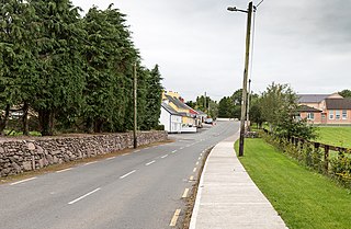
Aghabullogue or Aghabulloge is a village and parish in the barony of Muskerry East in County Cork, Ireland. It lies around 30 km (19 mi) west of Cork City, south of the Boggeragh Mountains and north of the River Lee.
Ballyvourney is a Gaeltacht village in southwest County Cork, Ireland. It is a civil parish in the barony of Muskerry West, and is also an ecclesiastical parish in the Roman Catholic Diocese of Cloyne. Ballyvourney is part of the Cork North-West Dáil Constituency.
Aherla is a small village in County Cork, Ireland, with a population of approximately 570. It is in the townlands of Aherla More and Rathard. Aherla is built on a limestone shelf typical of County Cork's ridges and valleys. The village is within the Cork North-West Dáil constituency.
Cúil Aodha, anglicised as Coolea, is a townland and village in the Gaeltacht region of Muskerry in County Cork, Ireland. The area is near the source of the River Sullane in the Derrynasaggart Mountains.
Carrigadrohid is a townland and village in the parish of Aghinagh, County Cork, Ireland. It is situated on the north bank of the River Lee, with the nearby village of Canovee to the south. Carrigadrohid is part of the Dáil constituency of Cork North-West.
Muskerry is a central region of County Cork, Ireland which incorporates the baronies of Muskerry West and Muskerry East. It is located along the valley of the River Lee and is bounded by the Boggeragh Mountains to the north and the Shehy Mountains to the south. The region is named after the Múscraige, who were an important Érainn people of Munster. It is also the name of an official Gaeltacht region in which Munster Irish is spoken. Gaeltacht villages include Béal Átha an Ghaorthaidh, Baile Bhuirne, Cúil Aodha and Cill na Martra. Major population centres include Ballincollig, Blarney and Macroom.
Farran is a village in County Cork, Ireland, in the parish of Ovens. It lies on the southside of the River Lee. Farran is 12 miles (19 km) west from Cork City on the N22 road.
Barretts is a barony in northwest County Cork in Ireland. The name is derived from the Old English Barrett family.
Kilculliheen is a civil parish, electoral division and barony in Ireland, on the north bank of the River Suir across from the centre of Waterford City. Historically, it has been transferred several times between the county of the city of Waterford and the counties of Kilkenny and Waterford. It now contains the only part of Waterford city on the left bank of the River Suir. The Parliamentary Gazetteer of 1846 states "as it lies on the left bank of the Suir, which, for the most part, divides co. Waterford from co. Kilkenny, most topographists mistakingly assign it to the barony of Ida, co. Kilkenny". It is now partly in County Kilkenny and partly in Waterford City. Of the barony's eleven townlands, five are entirely in Kilkenny and six are split between Kilkenny and Waterford. The city portion contains the formerly rural village of Ferrybank, which gives its name to a wider suburb which has spread across the county boundary.
Muskerry West is one of the baronies of Ireland, a historical geographical unit of land. Its chief town is Macroom. It is one of 24 baronies in the county of Cork. It may also be viewed as a half barony because sometime before the 1821 census, it was divided from its other half – Muskerry East. Other neighbouring baronies include Duhallow to the north and the Barony of Carbery East to the south.
Muskerry East is one of the baronies of Ireland, an historical geographical unit of land. Its chief town is Ballincollig. It is one of 24 baronies in the county of Cork. It may also be viewed as a half barony because some time before the 1821 census data, it was divided from its other half - Muskerry West. Other neighbouring baronies include Cork to the east, Duhallow to the north and the barony of Barretts to the north-east.
Aghavrin is a townland within both the civil parish and Catholic parish of Aghabullogue, County Cork, Ireland. It is 667.32 acres in size, situated south-west of Aghabullogue village, and north-west of Coachford village.
Moynoe is a civil parish in County Clare, Ireland. It is part of the Roman Catholic parish of Scarriff and Moynoe.
Carrignamuck is a townland within the civil parish of Magourney and catholic parish of Aghabullogue, County Cork, Ireland. It is 363.76 acres in size, situate north-east of Coachford village, and north-west of Dripsey village.
Clonmoyle East is a townland within both the civil parish and catholic parish of Aghabullogue, County Cork, Ireland. It is 756.05 acres in size, situate east of Aghabullogue village, and north of Coachford village.
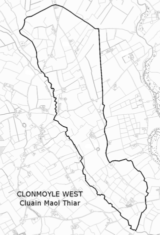
Clonmoyle West is a townland within both the civil parish and catholic parish of Aghabullogue, County Cork, Ireland. It is 774.06 acres in size, situate east of Aghabullogue village, and north-west of Coachford village.
Moyaliff is an old Civil Parish and townland in County Tipperary, Ireland. The old Civil parish was in the barony of Kilnamanagh Upper in the County of Tipperary. It had thirty one townlands in total. Twenty seven of these townslands are in the Roman Catholic Parish of Upperchurch-Drombane, three in the Roman Catholic parish of Holycross-Ballycahill and one townland Moyaliff itself shared between the two.
Coologe is a townland in the civil parish of Templeport, County Cavan, Ireland. It lies in the Roman Catholic parish of Templeport and barony of Tullyhaw.
Matehy is a civil parish in the historical barony of Muskerry East in County Cork, Ireland. The civil parish is centred on a small settlement, also referred to as Matehy, which contains a Roman Catholic church, a national (primary) school, and pub. Evidence of ancient settlement in the area include ringfort sites in Gilcagh townland, and a circular ecclesiastical enclosure containing the remains of a church and a number of 18th century gravestones.