
County Cork is the largest and the southernmost county of Ireland, named after the city of Cork, the state's second-largest city. It is in the province of Munster and the Southern Region. Its largest market towns are Mallow, Macroom, Midleton, and Skibbereen. As of 2022, the county had a population of 584,156, making it the third-most populous county in Ireland. Cork County Council is the local authority for the county, while Cork City Council governs the city of Cork and its environs. Notable Corkonians include Michael Collins, Jack Lynch, Mother Jones, Roy Keane, Sonia O'Sullivan, Cillian Murphy and Graham Norton.
Munster is one of the four provinces of Ireland, located in the south of the island. In early Ireland, the Kingdom of Munster was one of the kingdoms of Gaelic Ireland ruled by a "king of over-kings". Following the Norman invasion of Ireland, the ancient kingdoms were shired into counties for administrative and judicial purposes. In later centuries, local government legislation has seen further sub-division of the historic counties.

Leinster is one of the four provinces of Ireland, in the southeast of Ireland.
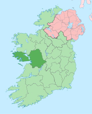
County Galway is a county in Ireland. It is in the Northern and Western Region, taking up the south of the province of Connacht. The county population was 276,451 at the 2022 census.
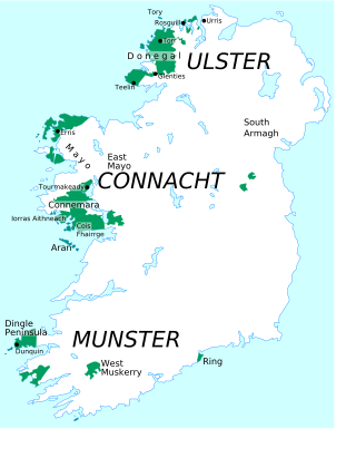
A Gaeltacht is a district of Ireland, either individually or collectively, where the Irish government recognises that the Irish language is the predominant vernacular, or language of the home. The Gaeltacht districts were first officially recognised during the 1920s in the early years of the Irish Free State, following the Gaelic revival, as part of a government policy aimed at restoring the Irish language.
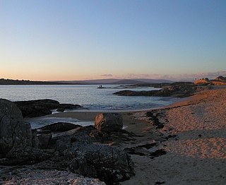
Clear Island or Cape Clear Island is an island off the south-west coast of County Cork in Ireland. It is the southernmost inhabited part of Ireland and had a population of 110 people as of the 2022 census.

The Iveragh Peninsula is located in County Kerry in Ireland. It is the largest peninsula in southwestern Ireland. A mountain range, the MacGillycuddy's Reeks, lies in the centre of the peninsula. Carrauntoohil, its highest mountain, is also the highest peak in Ireland.
Carraroe is a village in Connemara, the coastal Irish-speaking region (Gaeltacht) of County Galway, Ireland. It is known for its traditional fishing boats, the Galway Hookers. Its population is widely dispersed over the Carraroe peninsula between Cuan an Fhir Mhóir and Cuan Chasla. Carraroe has an unusual beach, Trá an Dóilín, a biogenic gravel beach made of coralline algae known as "maerl".

Ráth Chairn is a small village and Gaeltacht in County Meath, Ireland. It is about 55 km northwest of Dublin. Ráth Chairn Gaeltacht was founded in 1935 when 27 families from Connemara, mostly from Ceantar na nOileán, were settled on land previously acquired by the Irish Land Commission, followed by a further 11 families in 1937. In all 443 people moved to the area.
The twin villages of Ballineen and Enniskeane, or Enniskean, in County Cork in Ireland are 43 km (26.72 mi) southwest of Cork City, on the R586 road. The linear settlement lies on the River Bandon between Bandon and Dunmanway. The combined settlement is designated as a 'key village' by Cork County Council for planning purposes and, as of the 2016 census, had a population of 692 people.

The South-West is a strategic planning area within the Southern Region in Ireland. It is a NUTS Level III statistical region of Ireland. It includes the city of Cork and the counties of Cork and Kerry. The South-West region spans 12,120 km2 (4,680 sq mi), roughly 16% of the total area of the state and according to the 2022 census has a population of 736,489.

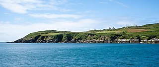
Ring or Ringagonagh is a parish within the Irish-speaking Gaeltacht na nDéise area in County Waterford, Ireland. It lies on a peninsula about eleven kilometres (7 mi) south of Dungarvan. The main settlement is the village of Ring or Ringville, which is within the townland of Ballynagaul.

Loch an Iúir, anglicised as Loughanure, is a village and townland in The Rosses, a district in the west of County Donegal in Ireland. The village is in the Gaeltacht, being halfway between Gweedore and Dungloe, with the N56 road passing through the village. According to the 2016 census, 37% of the population spoke Irish on a daily basis outside the education system. The village of Loughanure lies within the Barony of Boylagh.
Muskerry is a central region of County Cork, Ireland which incorporates the baronies of Muskerry West and Muskerry East. It is located along the valley of the River Lee and is bounded by the Boggeragh Mountains to the north and the Shehy Mountains to the south. The region is named after the Múscraige, who were an important Érainn people of Munster. It is also the name of an official Gaeltacht region in which Munster Irish is spoken. Gaeltacht villages include Béal Átha an Ghaorthaidh, Baile Bhuirne, Cúil Aodha and Cill na Martra. Major population centres include Ballincollig, Blarney and Macroom.

Irish, also known as Irish Gaelic or simply Gaelic, is a Celtic language of the Indo-European language family. It is a member of the Goidelic languages of the Insular Celtic sub branch of the family and is indigenous to the island of Ireland. It was the majority of the population's first language until the 19th century, when English gradually became dominant, particularly in the last decades of the century, in what is sometimes characterised as a result of linguistic imperialism.
A Neo-Gaeltacht is an area where Irish has a strong presence as a spoken language but is not part of the officially defined or traditional Gaeltacht areas. It has been argued that non-Gaeltacht activist groups wishing to establish an Irish language community need to show that it is large, permanent and formally organised and that it has a growing number of people using Irish as their first language. Another objective is a situation in which children use Irish among themselves and with other Irish speakers in a natural way while being able to deal with a largely English-speaking world.

Baile Ghib is a small village and Gaeltacht in County Meath, Ireland. It is about 70km northwest of Dublin city. Local Link bus route 186 was introduced in October 2024 and links the area several times daily to Kells and other villages in Meath & Cavan.
The Achréidh na Gaillimhe comprises five electoral divisions: Bearna, Baile an Bhriotaigh, An Caisleán Gearr, Mionlach and Cnoc na Cathrach. Due to its proximity to Ireland's biggest Gaeltacht, Galway city has always been important for the language movement and many Irish speakers settling or moving to Galway. According to the 2016 census, 31,583 people (41%) in Galway City said they could speak Irish, but only 2,344 people (3%) spoke it daily.
The 20-Year Strategy for the Irish Language 2010–2030 is a policy and planning document launched by the Government of Ireland on 20 December 2010 and which will be in operation until December 2030.
Meenlaragh is a village and townland located in County Donegal, Ireland.


