Monkstown, County Cork

Last updated

Monkstown
Baile an Mhanaigh
Village
Glen Road - geograph.org.uk - 1427245.jpg
Glen Road, Monkstown
Ireland adm location map.svg
Red pog.svg
Monkstown
Location in Ireland
Coordinates: 51°51′01″N8°20′02″W / 51.850141°N 8.333967°W / 51.850141; -8.333967
Country Ireland
Province Munster
County County Cork
Elevation
30 m (100 ft)
Time zone UTC+0 (WET)
  Summer (DST) UTC-1 (IST (WEST))
Irish Grid Reference W767687

Monkstown (Irish : Baile an Mhanaigh - 'the town of the monk', formerly anglicised as Ballinvannegh) [1] is a village in County Cork, Ireland, in the old barony of Kerrycurrihy. It lies 14 kilometres southeast of Cork city on the estuary of the River Lee, facing Great Island and looking onto Monkstown Bay. For census purposes, Monkstown is combined with the nearby town of Passage West, and the combined area has a population of approximately 5,800 residents. [2] The village is in a townland and civil parish of the same name. [1] The Catholic parish of Monkstown includes the nearby villages of Shanbally and Ringaskiddy. [3]

Contents

History and name

The name of the village is said to derive from an early monastic site near to where Monkstown Castle now stands. [4] [5] Although no archaeological evidence remains for the monastery, the site of the monastery's abbey is referenced (as Legan Abbey) in 19th century maps and works. [6] [7] Over time, the name Baile an Mhanaigh/Monkstown overtook the old name Baile an Fealach (Foley's homestead), although the latter name persists in the name of a townland of the village: Ballyfouloo. [8]

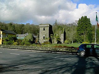
Monkstown Castle

Monkstown Castle Castles of Munster, Monkstown, Cork (1) - geograph.org.uk - 6530731.jpg
Monkstown Castle

Monkstown Castle is a fortified tower house that was constructed around 1636 by Anastasia Archdeacon, reputedly as a surprise gift for her husband John. [9] [10] He had been fighting with the Spanish Catholics in the continental wars of the time. [11] As implausible legend has it that, when John Archdeacon's ship entered Monkstown bay, a cannonball was fired at the castle, as it was believed to have been built by an occupying force. [9] Anastasia Archdeacon hired workers to come to Monkstown to build the castle. She housed the workers (in accommodation built specially for them), and fed and clothed them (for a price). Once the workers had settled up their bills with her, it is said that the overall cost of the castle worked out at about four pence.[ citation needed ]

The castle was, over the centuries, owed or occupied by Cromwellian soldier Thomas Plunkett, Archbishop of Armagh Michael Boyle, and the Bernard Shaw family. [9] Later used as a club house for the nearby Monkstown Golf Club, the castle was seriously damaged by fire in the 1970s. [12] The castle has since been partially renovated and, as of 2021, on the market for sale. [13]

Notable residents

See also

Related Research Articles

<span class="mw-page-title-main">Monkstown, County Dublin</span> Suburb of Dublin. Ireland

Monkstown, historically known as Carrickbrennan, is a suburb in south Dublin, located in Dún Laoghaire–Rathdown, Ireland. It is on the coast, between Blackrock and Dún Laoghaire while also bordering Sallynoggin and Deansgrange inland.

<span class="mw-page-title-main">Great Island</span> Island in Cork Harbour, Ireland

Great Island is an island in Cork Harbour, at the mouth of the River Lee and close to the city of Cork, Ireland. The largest town on the island is Cobh. The island's economic and social history has historically been linked to the naval, ship-building, and shipping activities in the town's environs.

<span class="mw-page-title-main">Galbally, County Limerick</span> Village in County Limerick, Ireland

Galbally is a village in southeast County Limerick, Ireland, on the border with County Tipperary. It is located at the foot of the Galtee Mountains and at the western approach to the Glen of Aherlow. The Aherlow River, flowing down from the Galtee mountains, runs by the village, to meet the Suir at Kilmoyler a short distance north of Cahir. Galbally is in a valley overlooked by the Galtee Mountains. The village is in a townland and civil parish of the same name.
<span class="mw-page-title-main">Ballyvourney</span> Village in County Cork, Ireland

Ballyvourney is a Gaeltacht village in southwest County Cork, Ireland. Ballyvourney is also a civil parish in the barony of Muskerry West, and an ecclesiastical parish in the Roman Catholic Diocese of Cloyne. The village is part of the Cork North-West Dáil Constituency.

Monkstown is a townland and electoral ward in County Antrim, Northern Ireland. It is within the urban area of Newtownabbey and the Antrim and Newtownabbey Borough Council area. The townland was previously called Ballynamanagh It is also situated in the civil parish of Carnmoney and the historic barony of Belfast Lower.

Glenbrook is a village in the townland of Lackaroe, between Passage West and Monkstown in County Cork, Ireland. Monkstown, Glenbrook and Passage West are three villages along Cork Harbour's R610 route. The Cross River Ferry at Glenbrook links the Owenabue Valley with East Cork, Fota Island and Cobh.

<span class="mw-page-title-main">Naul, Dublin</span> Village in County Dublin, Ireland

Naul, is a village, townland, and civil parish at the northern edge of the traditional County Dublin in Ireland. The Delvin River to the north of the village marks the county boundary with County Meath. Naul civil parish is in the historic barony of Balrothery West.

<span class="mw-page-title-main">Tullyallen, County Louth</span> Village in Ireland

Tullyallen is a village, civil parish and townland 6 km north-west of the town of Drogheda in County Louth, Ireland. It is in the historic Barony of Ferrard. It is located in the historical Boyne Valley, in the Catholic parish of Mellifont ; it is also close to Newgrange, Knowth and Dowth burial mounds, Monasterboice monastery, and to the Battle of the Boyne site.

<span class="mw-page-title-main">Glanworth</span> Village in County Cork, Ireland

Glanworth is a village on the R512 regional road in County Cork, Ireland. It lies approximately 8 kilometres (5 mi) northwest of the town of Fermoy and 40 km (25 mi) northeast of Cork city. As of 2022, Glanworth's population was 628.

<span class="mw-page-title-main">Castletownroche</span> Village in County Cork, Ireland

Castletownroche is a townland, village, and civil parish in the barony of Fermoy, County Cork, Ireland. It is located on the N72 national secondary road. In ancient times, it was known in Irish as Dún Chruadha, meaning Cruadha's Fort. Castletownroche is located on the River Awbeg in the Blackwater Valley about eight miles (13 km) from Mallow. Castletownroche is within the Cork East Dáil constituency.

Newtowncashel is a village located near Lough Ree in County Longford, Ireland. Newtowncashel won the Irish Tidy Towns Competition in 1980.

<span class="mw-page-title-main">Fore, County Westmeath</span> Village in Leinster, Ireland

Fore is a village, next to the old Benedictine Abbey ruin of Fore Abbey, situated to the north of Lough Lene in County Westmeath, in Ireland.

<span class="mw-page-title-main">Ballynacargy</span> Village in County Westmeath, Ireland

Ballynacargy, or Ballinacarrigy, is a small village in County Westmeath, Ireland on the Royal Canal and the R393 regional road. The last official commercial navigation of the canal took place in 1955.

<span class="mw-page-title-main">Kilsheelan</span> Village in County Tipperary, Ireland

Kilsheelan is a village and civil parish within the barony of Iffa and Offa East in County Tipperary, Ireland. A part of the civil parish is in neighbouring County Waterford. It is also one half of the Roman Catholic parish of Kilsheelan & Kilcash in the Roman Catholic Diocese of Waterford and Lismore.
<span class="mw-page-title-main">Gortnahoe</span> Village in Munster, Ireland

Gortnahoe, also known as Gortnahoo, is a village in County Tipperary, Ireland. It is located on the R689 regional road 6 km (3.7 mi) south of Urlingford, County Kilkenny. It is 3 km (1.9 mi) southeast of the N8 Dublin - Cork road. Gortnahoe, pronounced "Gurt/na/hoo" by the locals, is part of the parish of Gortnahoe–Glengoole.

<span class="mw-page-title-main">Farran</span> Village in County Cork, Ireland

Farran is a village in County Cork, Ireland, in the parish of Ovens. It lies on the southside of the River Lee. Farran is 12 miles (19 km) west from Cork City on the N22 road.

Ballard is a townland in west County Clare, Ireland. It is on the N67 national secondary road between the urban areas of Doonbeg and Kilkee. The nearest large towns are Kilrush and Kilkee, which are approximately 10 and 5 miles away, respectively.

<span class="mw-page-title-main">Ballinora</span> Townland in County Cork, Ireland

Ballinora or Ballynora is a small rural parish and townland near Cork city and Ballincollig in County Cork, Ireland. The townland, which lies in the civil parish of Kilnaglory, is home to several education facilities and sporting clubs. The village of Waterfall is nearby.

<span class="mw-page-title-main">Minane Bridge</span> Village in County Cork, Ireland

Minane Bridge is a village in County Cork, Ireland. It is in the townland of Minane, 20 km south of Cork city and 5 km south of Carrigaline. The local church is Sacred Heart Church of Tracton Abbey Parish. Minane Bridge is part of the Dáil constituency of Cork South-Central.

<span class="mw-page-title-main">Milltown, County Cavan</span> Village in County Cavan, Ireland

Milltown is a small village in County Cavan, Ireland. The population as at 2021 was around 100. During a nineteenth century O'Donavan townlands survey of County Cavan it was noted that the Milltown area was traditionally referred to as Bellanaleck, there are no other records with this name. The Archaeological Inventory of County Cavan notes (507) Derrygeeraghan, a raised circular Rath area with two substantial earthen banks and a wide deep fosse dating from earlier medieval times. The present Milltown Electoral Division and catchment area comprises several neighboring townlands within an ancient Barony of Loughtee Lower, County Cavan and Drumlane Civil Parish in County Cavan.
References

  1. 1 2 "Monkstown (see archival records)". Placenames Database of Ireland. Retrieved 6 December 2017.
  2. "Settlement Passage West Legal Town And Its Environs (CSO Area Code ST 18019)". Census 2011. Central Statistics Office. April 2011. Retrieved 9 July 2020.
  3. "Monkstown". Diocese of Cork + Ross. Retrieved 3 July 2024.
  4. "Monkstown". Monkstown.org. Archived from the original on 25 May 2007.
  5. "Passage West Monkstown - History". Passagewestmonkstown.ie. Archived from the original on 29 October 2016.
  6. "Map of Monkstown Castle Area (Site of Lagan Abbey)" (Map). Historic Map 25 inch (1888-1913). Ordnance Survey Ireland. Retrieved 8 November 2018 via geohive.
  7. Lewis, Samuel (1837). A Topological History of Ireland via libraryireland.com. Monkstown [..] derives its name from a small establishment of Benedictine monks, called Legan abbey, belonging to the priory of St. John's
  8. "Monkstown Civil Parish → Monkstown Rural Electoral Division → Ballyfouloo". Townlands.ie. Retrieved 6 December 2017.
  9. 1 2 3 "Monkstown Castle, Monkstown, County Cork". National Inventory of Architectural Heritage. Retrieved 8 November 2018.
  10. "Fix it up: Monkstown Castle, Co Cork". independent.ie. Independent News & Media. 29 September 2017. Retrieved 8 November 2018.
  11. David Dickson (2005). Old World Colony: Cork and South Munster 1630-1830. Cork University Press. p. 24. ISBN   9781859183557. Monkstown Castle [..was..] built apparently by Anastasia Archdeacon (née Galwey) while her husband was overseas in Spanish military service
  12. "Historic Monkstown Castle is ripe for final restoration". irishexaminer.com. Irish Examiner. 7 May 2016. Retrieved 8 November 2018.
  13. "Gallery: You can buy your very own castle in Cork and the price isn't too bad". corkbeo.ie. 10 August 2021. Retrieved 19 August 2021.