Halfway, County Cork

Last updated

Halfway
Irish: Leath Slighe
Village
Halfway Viaduct, near Ballinhassig, Co, Cork - geograph.org.uk - 78690.jpg
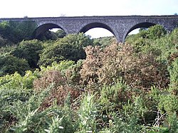
The Halfway Viaduct, on the former Cork, Bandon and South Coast Railway, sits above the village
Ireland adm location map.svg
Red pog.svg
Halfway
Location in Ireland
Coordinates: 51°48′07″N8°34′25″W / 51.801967°N 8.573542°W / 51.801967; -8.573542
Country Ireland
Province Munster
County Cork
Population
 (2016) [1]
226
Time zone UTC+0 (WET)
  Summer (DST) UTC-1 (IST (WEST))
Irish Grid Reference W605615

Halfway (Irish : Leath Slighe) is a village in County Cork, in Ireland. Halfway got its name from being situated approximately halfway between Cork City and Bandon.

Halfway is situated on the L2231, just off the N71, close to the neighbouring village of Ballinhassig. Ballinhassig Garda station is located in Halfway. [2] Halfway formerly had two pubs; however, there is now only the Ramble Inn pub.[ citation needed ] There is also an angling shop. [3]

The annual Halfway Vintage Rally, a meeting of vintage car owners and enthusiasts, takes place over one weekend in September.[ citation needed ] Road bowling is sometimes played on the national road between the villages of Halfway and Ballinhassig. [4]

Evidence of ancient settlement in the area includes several ringforts in the neighbouring townlands of Gortnaclogh, Annagh Beg and Rathroe. [5]

See also

Related Research Articles

<span class="mw-page-title-main">Ballinhassig</span> Village in County Cork, Ireland

Ballinhassig is a village in County Cork, Ireland, situated 10.6 km (6.6 mi) south of Cork City just off the N71 Bandon road and near the source of the River Owenabue.

<span class="mw-page-title-main">Athea</span> Village in County Limerick, Ireland

Athea is a village in west County Limerick, Ireland. Athea has a Roman Catholic church, and is the centre for the parish of Athea, which encompasses several nearby townlands.

<span class="mw-page-title-main">Innishannon</span> Village in County Cork, Ireland

Innishannon or Inishannon is a large village on the main Cork–Bandon road (N71) in County Cork, Ireland. Situated on the River Bandon, the village has grown due to its proximity to Cork city, and is now a dormitory town for city workers.

Monasteraden is a village in County Sligo, Ireland. The village is located on the shores of Lough Gara. St Aiden's church is the village's church. Other sites include Lough Gara Lodge, Slí na Croí's Roundhouse Ecolodge, Drury's pub and the general store.

<span class="mw-page-title-main">Riverstown</span> Village in County Sligo, Ireland

Riverstown, historically called Ballyederdaowen, is a village in County Sligo, Ireland. Known for its musical tradition it is located at a bridging point of the River Unshin (Arrow), 17.2 km south of Sligo town and 4 km east of the N4 road.

<span class="mw-page-title-main">Stradone, County Cavan</span> Village in County Cavan, Ireland

Stradone is a village located in County Cavan, Ireland. It is situated in the civil parish of Laragh six miles from Cavan, near the N3 road between Cavan and Virginia. Stradone is classified as a 'small village' in the Cavan County Council Development Plan 2014-2020.

<span class="mw-page-title-main">Stepaside, Dublin</span> Suburban village on outskirts of Dublin, Ireland

Stepaside is a village in the townland of Kilgobbin, on the southern edge of Dublin, in Dún Laoghaire–Rathdown, Ireland. The area is 4 kilometres (2.5 mi) south of Dundrum.

<span class="mw-page-title-main">Cappoquin</span> Town in County Waterford, Ireland

Cappoquin, also sometimes spelt Cappaquin, is a town in western County Waterford, Ireland. It is on the Blackwater river at the junction of the N72 national secondary road and the R669 regional road. It is positioned on a sharp 90-degree bend in the river and lies at the foot of the Knockmealdown Mountains. The town is a few miles from Mount Melleray and Lismore, County Waterford.

<span class="mw-page-title-main">N71 road (Ireland)</span> Road in Ireland

The N71 road is a national secondary road traversing counties Cork and Kerry in Ireland. Towns and villages along the route, westward from Cork city, include Innishannon, Bandon, Clonakilty, Skibbereen, Bantry and Glengarriff in County Cork. Continuing westwards from Glengarriff into County Kerry, the route passes Kenmare and terminates at Killarney.

<span class="mw-page-title-main">Arvagh</span> Village in County Cavan, Ireland

Arvagh, or Arva, is a village in County Cavan, Ireland, on the shores of Garty Lough and overlooked by Bruse Mountain. It is located on the junction of the R198 and R203 regional roads.

<span class="mw-page-title-main">Gweesalia</span> Village in Connacht, Ireland

Gweesalia or Geesala is a small Gaeltacht village situated on the Gweesalia peninsula in the Electoral Division of Rathhill, in the Civil Parish of Kilcommon, in the Barony of Erris in western County Mayo, Ireland.

<span class="mw-page-title-main">Glanworth</span> Village in County Cork, Ireland

Glanworth is a village on the R512 regional road in County Cork, Ireland. It lies approximately 8 kilometres (5 mi) northwest of the town of Fermoy and 40 km (25 mi) northeast of Cork city. As of 2016, Glanworth's population was 603.

<span class="mw-page-title-main">Dundrum, County Tipperary</span> Village in County Tipperary, Ireland

Dundrum is a village in County Tipperary, Ireland. In the 2016 census, the population was 165. It is in the barony of Kilnamanagh Lower.

<span class="mw-page-title-main">Castletownroche</span> Village in County Cork, Ireland

Castletownroche is a townland, village, and civil parish in the barony of Fermoy, County Cork, Ireland. It is located on the N72 national secondary road. In ancient times, it was known in Irish as Dún Chruadha, meaning Cruadha's Fort. Castletownroche is located on the River Awbeg in the Blackwater Valley about eight miles (13 km) from Mallow. Castletownroche is within the Cork East Dáil constituency.

<span class="mw-page-title-main">Moneygall</span> Village in County Offaly, Ireland

Moneygall is a small village on the border of counties Offaly and Tipperary, in Ireland. It is situated on the R445 road between Dublin and Limerick. There were 313 people living in the village as of the 2016 census. Moneygall has a Catholic church, motorway service station, a car sales and repair centre, a national school, a Garda station and two pubs. The nearest Church of Ireland church, Borrisnafarney, is 2 km from the village beside the former Loughton Demesne.

Drumlish is a village in County Longford, Ireland on the R198 regional road 10 km (6.2 mi) north of Longford Town.

<span class="mw-page-title-main">Crookstown, County Cork</span> Village in County Cork, Ireland

Crookstown is a small village in County Cork in Ireland, about 12 km east of the town of Macroom and about 1 km off the N22 Cork-Killarney road. It had a population of 245 as of the 2016 census, down from 285 in the 2011 census.

<span class="mw-page-title-main">Drumconrath</span> Village in County Meath, Ireland

Drumconrath or Drumcondra is a small village in north County Meath, Ireland. The parish borders County Louth and is also close to the borders of Counties Monaghan and Cavan. As of the 2016 census, the village had a population of 345 people.

<span class="mw-page-title-main">Boherbue</span> Village in County Cork, Ireland

Boherbue or Boherboy is a village in north-west County Cork, Ireland. The village is in the civil parish of Kilmeen in the Barony of Duhallow, and spans the townlands of Gneeves, Laharan and Derrynatubbrid. Boherbue is within the Cork North-West Dáil constituency.

<span class="mw-page-title-main">Knockavilla, County Cork</span> Village in County Cork, Ireland

Knockavilla is a small village in County Cork, Ireland, a few of kilometres from Crossbarry and Innishannon. The local Roman Catholic church is dedicated to Saint Patrick. There is also a school, a pub, a graveyard, and a community hall. Knockavilla Celtic is the local association football club.

References

  1. "Sapmap Area - Settlements - Halfway". Census 2016. Central Statistics Office. April 2016. Archived from the original on 13 February 2018. Retrieved 4 November 2020.
  2. "Ballinhassig Garda Station, Halfway, Ballinhassig, Co. Cork". garda.ie. An Garda Síochána. Archived from the original on 31 March 2021. Retrieved 23 December 2020.
  3. "Tackle Direct Ireland - Contact Us". tackledirectireland.ie. Halfway Angling Centre. Archived from the original on 26 January 2021. Retrieved 23 December 2020.
  4. "Club Results". irishroadbowling.ie. Archived from the original on 6 February 2008. Retrieved 5 March 2008.
  5. "Recorded Monuments Protected under Section 12 of the National Monuments (Amendment) Act, 1994 County Cork" (PDF). archaeology.ie. National Monuments and Historic Properties Service. 1998. Archived (PDF) from the original on 1 September 2021. Retrieved 4 November 2020.
A pillbox, dating to The Emergency (1939-1945), sits on the old Cork-Bandon road through Halfway Pill box bunker on the old Cork to Bandon Road (geograph 4855003).jpg
A pillbox, dating to The Emergency (1939-1945), sits on the old Cork–Bandon road through Halfway