
County Cork is the largest and the southernmost county of Ireland, named after the city of Cork, the state's second-largest city. It is in the province of Munster and the Southern Region. Its largest market towns are Mallow, Macroom, Midleton, and Skibbereen. As of 2022 the county had a population of 581,231, making it the third-most populous county in Ireland. Cork County Council is the local authority for the county, while Cork City Council governs the city of Cork and its environs. Notable Corkonians include Michael Collins, Jack Lynch, Roy Keane, Sonia O'Sullivan and Cillian Murphy.

This is a list of the extreme points of Ireland – the points that are farthest north, south, east or west in Ireland. It includes the Republic of Ireland and Northern Ireland.

Barleycove or Barley Cove is a bay and beach in County Cork, on the south coast of Ireland. It is situated close to Mizen Head on the Mizen Peninsula, with Crookhaven or Goleen being the nearest villages. The area surrounding Barleycove is popular during the summer months. The beach itself has been designated as one of several Special Areas of Conservation in Ireland under the European Union's Habitats Directive, due to the variety of wildlife and habitats in the sand dunes.

West Cork is a tourist region and municipal district in County Cork, Ireland. As a municipal district, West Cork falls within the administrative area of Cork County Council, and includes the towns of Bantry, Castletownbere, Clonakilty, Dunmanway, Schull and Skibbereen, and the 'key villages' of Baltimore, Ballydehob, Courtmacsherry, Drimoleague, Durrus, Glengarriff, Leap, Rosscarbery, Timoleague and Union Hall.

Bantry is a town in the civil parish of Kilmocomoge in the barony of Bantry on the southwest coast of County Cork, Ireland. It lies in West Cork at the head of Bantry Bay, a deep-water gulf extending for 30 km (19 mi) to the west. The Beara Peninsula is to the northwest, with Sheep's Head peninsula to the southwest.

Crookhaven is a village in County Cork, Ireland, on the most southwestern tip of the island of Ireland. With an out-of-season population of about sixty, it swells in the summer season to about four hundred, when the occupants of the seasonal holiday homes arrive.

Mizen Head is traditionally regarded as the most southerly point of mainland Ireland although Brow Head is the actual southernmost point. It is at the end of the Mizen Peninsula in the district of Carbery in County Cork.

Schull or Skull is a town in County Cork, Ireland.
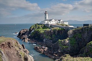
Fanad is a peninsula that lies between Lough Swilly and Mulroy Bay on the north coast of County Donegal, Ireland. The origin of the name Fanad derives from the Irish language word Fána for "sloping ground". It is also referred to as Fannet or Fannett in older records. There are an estimated 700 people living in Fanad and 30% Irish speakers.

Adrigole is a village on the Beara Peninsula in County Cork, Ireland. It is centred on the junction of the R572 and R574 regional roads. The electoral division in which the village sits has a sparsely distributed population of about 450 people.

Durrus is a village and civil parish in West Cork in Ireland. It is situated ten kilometres (6 mi) from Bantry in County Cork, at the head of the Sheep's Head and the Mizen Head peninsulas.
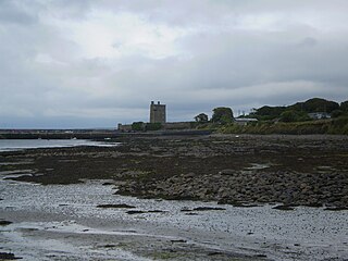
Carrigaholt is a small fishing village in County Clare, Ireland, a castle and a Catholic parish by the same name. The area was officially classified as part of the West Clare Gaeltacht; an Irish-speaking community; until 1956.

Brow Head is the most southerly point of mainland Ireland. It is in the rural townland of Mallavoge near Crookhaven in County Cork, Ireland. It is 3.8 km east of Mizen Head at latitude 51.43ºN.
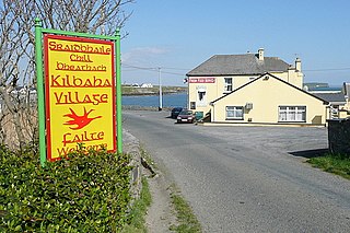
Kilbaha is a small fishing village in County Clare, Ireland. It is located close to the western end of the Loop Head peninsula on the R487 road.

Dunlough Castle, standing atop the cliffs at the northern tip of the Mizen Peninsula, looks at the Atlantic Ocean from the extreme southwest point of Ireland. Founded in 1207 by Donagh O’Mahony, Dunlough is one of the oldest castles in Ireland and an example of Norman architecture and dry stone masonry.

Rock Island is a promontory in West Cork, Ireland, situated about 2 kilometres (1.2 mi) south of the village of Goleen, at the entrance to the inlet of Crookhaven.

Nohoval is a village located in County Cork, Ireland. St. Patrick's and Nohoval Parish Church are located in the village. It is approximately 26 kilometres (16 mi) south of the city of Cork, approximately 16 km (9.9 mi) south of Carrigaline and 10 km (6.2 mi) east of Kinsale.
John James Murphy PP was an Irish archdeacon.

Kilballyowen is the name of both a civil parish and a townland within that parish in County Clare, Ireland. The name is also occasionally used for the slightly larger Catholic parish of Cross.

The R591 road is a regional road in Ireland. It is a road on the Mizen Peninsula in County Cork. Most of the road forms part of the Wild Atlantic Way.


