Montenotte, Cork

Last updated

Montenotte
Suburb
Montenotte, Cork.jpg
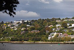
Montenotte as seen from the opposite (south) side of the River Lee
Ireland adm location map.svg
Red pog.svg
Montenotte
Location in Ireland
Coordinates: 51°54′21″N08°26′35″W / 51.90583°N 8.44306°W / 51.90583; -8.44306
Country Ireland
Province Munster
County County Cork
Time zone UTC+0 (WET)
  Summer (DST) UTC-1 (IST (WEST))
Eircode
T23
Area code 021

Montenotte is an area in the northeast of Cork City, Ireland, which was home to merchants and a prosperous middle class from the early to mid-19th century. [1] It was named after the late 18th century Napoleonic battle, the Battle of Montenotte, which took place in Northern Italy. [2] The suburb comprises two electoral districts (Montenotte A and Montenotte B) within the Dáil constituency of Cork North-Central. [3] As of 2002, the populations of these electoral districts were 1,853 and 2,723 respectively. [4]

Development

Montenotte is situated on a hill facing south over the River Lee adjacent to the St Luke's area (near St Luke's church). Originally home to several substantial residences, some of these large homes were later converted for institutional or commercial uses.[ citation needed ]

The river-facing area of Montenotte has significant mature tree coverage.[ citation needed ] During the 20th century, lands were sold for private housing development and the tree covered hillside is dotted with low density modern housing overlooking the River Lee.[ citation needed ]

Local businesses include the Montenotte Hotel.

Related Research Articles

<span class="mw-page-title-main">County Cork</span> County in Ireland

County Cork is the largest and the southernmost county of Ireland, named after the city of Cork, the state's second-largest city. It is in the province of Munster and the Southern Region. Its largest market towns are Mallow, Macroom, Midleton, and Skibbereen. As of 2022, the county had a population of 581,231, making it the third-most populous county in Ireland. Cork County Council is the local authority for the county, while Cork City Council governs the city of Cork and its environs. Notable Corkonians include Michael Collins, Jack Lynch, Roy Keane, Sonia O'Sullivan, Cillian Murphy, and Graham Norton.

<span class="mw-page-title-main">Macroom</span> Town in County Cork, Ireland

Macroom is a market town in County Cork, Ireland, located in the valley of the River Sullane, halfway between Cork city and Killarney. Its population has grown and receded over the centuries as it went through periods of war, famine and workhouses, forced emigration and intermittent prosperity. The 2011 census gave an urban population of 3,879 people, while the 2016 census recorded 3,765 people.

<span class="mw-page-title-main">Crosshaven</span> Village in Cork Harbour, Ireland

Crosshaven is a village in County Cork, Ireland. It is located in lower Cork Harbour at the mouth of the River Owenabue, across from Currabinny Wood. Originally a fishing village, from the 19th century, the economy of the area became more reliant on a growing tourism industry.

<span class="mw-page-title-main">Castleconnell</span> Village in County Limerick, Ireland

Castleconnell is a village in County Limerick on the banks of the River Shannon. It is 11 km (6.8 mi) from Limerick city and near the boundaries of County Clare and County Tipperary.

<span class="mw-page-title-main">West Cork</span> Region of County Cork, Ireland

West Cork is a tourist region and municipal district in County Cork, Ireland. As a municipal district, West Cork falls within the administrative area of Cork County Council, and includes the towns of Bantry, Castletownbere, Clonakilty, Dunmanway, Schull and Skibbereen, and the 'key villages' of Baltimore, Ballydehob, Courtmacsherry, Drimoleague, Durrus, Glengarriff, Leap, Rosscarbery, Timoleague and Union Hall.

<span class="mw-page-title-main">Dunmanway</span> Town in County Cork, Ireland

Dunmanway is a market town in County Cork, in the southwest of Ireland. It is the geographical centre of the region known as West Cork. It is the birthplace of Sam Maguire, an Irish Protestant republican, for whom the trophy of the All-Ireland Senior Football Championship is named.

<span class="mw-page-title-main">Ballincollig</span> Town in Cork city, Ireland

Ballincollig is a suburban town within the administrative area of Cork city in Ireland. It is located on the western side of Cork city, beside the River Lee on the R608 regional road. In 2016 it was the largest town in County Cork, at which time the Ballincollig Electoral Division had a population of 18,621 people. It is located beyond the green belt from the suburbs of Bishopstown and Wilton. Historically home to the Ballincollig Royal Gunpowder Mills which is now a Regional Park, the town has seen much growth in recent years as a satellite of Cork City. Ballincollig is within the Cork North-West Dáil constituency.

<span class="mw-page-title-main">Monkstown, County Cork</span> Village in County Cork, Ireland

Monkstown is a village in County Cork, Ireland, in the old barony of Kerrycurrihy. It lies 14 kilometres southeast of Cork city on the estuary of the River Lee, facing Great Island and looking onto Monkstown Bay. For census purposes, Monkstown is combined with the nearby town of Passage West, and the combined area has a population of approximately 5,800 residents.

<span class="mw-page-title-main">River Lee</span> River crossing Cork (county and city), Ireland

The River Lee is a river in Ireland. It rises in the Shehy Mountains on the western border of County Cork and flows eastwards through Cork, where it splits in two for a short distance, creating an island on which Cork's city centre is built, then passing through Cork Harbour on the south coast, one of the largest natural harbours in the world, to empty into the Celtic Sea. The catchment area of the River Lee is 1,253 km2. The long-term average flow rate of the River Lee is 40.4 cubic metres per second (m3/s)

Cork North-Central is a parliamentary constituency represented in Dáil Éireann, the lower house of the Irish parliament or Oireachtas. The constituency elects 4 deputies on the system of proportional representation by means of the single transferable vote (PR-STV).

Mahon is an area to the south-eastern side of Cork, Ireland. Mahon gets its name from Lough Mahon, a wide stretch of the upper section of Cork Harbour. It was once a semi-rural peninsula, but from the late 20th century was subject to residential development, and has a number of housing estates and developments. The area was generally known as the Ring of Mahon, and is the site of Ringmahon House. Mahon is within the Cork South-Central Dáil constituency.

<span class="mw-page-title-main">Ballyvourney</span> Village in County Cork, Ireland

Ballyvourney is a Gaeltacht village in southwest County Cork, Ireland. It is a civil parish in the barony of Muskerry West, and is also an ecclesiastical parish in the Roman Catholic Diocese of Cloyne. Ballyvourney is part of the Cork North-West Dáil Constituency.

<span class="mw-page-title-main">Douglas, Cork</span> Suburb in Cork city, Ireland

Douglas is a suburb, with a village core, in Cork city, Ireland. Douglas is also the name of the townland, Roman Catholic parish, Church of Ireland parish and civil parish in which it is contained.

<span class="mw-page-title-main">Knocknaheeny</span> Suburb in Cork North-Central, Cork, Ireland

Knocknaheeny is an electoral division and suburb in Cork city, located north of the River Lee on hills overlooking the city. It is a mainly residential area, and contains a number of terraced council housing estates. Apple's headquarters for Europe, the Middle East and Africa is located in the area, and employs about 3,000 people.

<span class="mw-page-title-main">Cork (city)</span> City in County Cork, Munster, Ireland

Cork is the second largest city in the Republic of Ireland, third largest on the island of Ireland, and largest in the province of Munster. At the 2022 census, it had a population of 222,333.

The Mardyke is an area in Cork city, on the northern half of the long western part of the island formed by the two channels of the River Lee near the city centre. It was historically left as open space because the land along the north channel of the river is prone to flooding. From east to west these open spaces are: Presentation Brothers College, a boy's secondary school; the Mardyke ground of Cork County Cricket Club; Fitzgerald Park, which includes Cork Public Museum; Sunday's Well Lawn Tennis Club; and the athletic grounds of University College Cork.

The Montenotte Hotel is a four star hotel in Cork, Ireland.

<span class="mw-page-title-main">Rochestown</span>

<span class="mw-page-title-main">Wellington Road, Cork</span>

Wellington Road is a road on the north-side of Cork city. Wellington Road stretches almost a kilometre from St. Patricks Place, to St. Lukes Cross at the eastern end of the road.

The Glen is a predominantly residential area on the north side of Cork City, Ireland. The area consists of mostly social housing estates near an ancient glacial valley known as the 'Glen River Park'. The Glen is within the Dáil constituency of Cork North-Central, and made up of the electoral division of the Glen A and Glen B. The Glen A electoral division recorded a population of 2,354 in the 2011 census.

References

  1. "History of Cork city - Cork in the Nineteenth Century". Archived from the original on 19 November 2007.
  2. "Frankie Whelehan's €5m Montenotte hotel spend". irishexaminer.com. Irish Examiner. 21 April 2016.
  3. "The City of Cork Boundary Revisions". Cork City Council. Archived from the original on 19 November 2007. Retrieved 19 January 2008.
  4. "Cork City-online population 2002". foundmark.com. Archived from the original on 20 November 2007. Retrieved 19 January 2008.

51°54′21″N8°26′35″W / 51.90583°N 8.44306°W / 51.90583; -8.44306